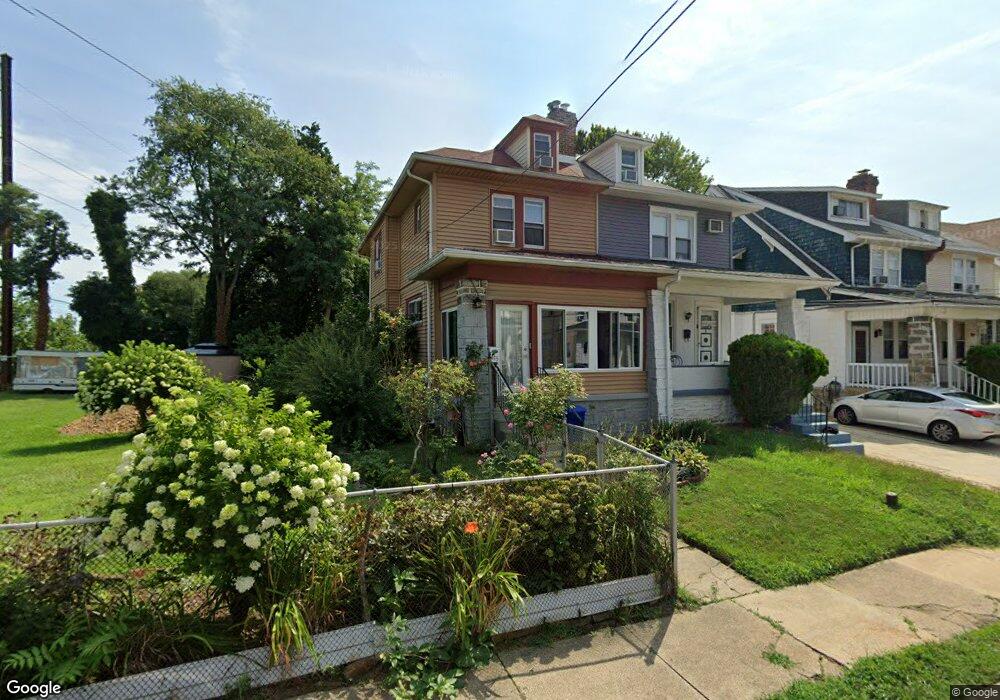
415 Laurel Rd Lansdowne, PA 19050
Estimated Value: $214,000 - $256,000
3
Beds
1
Bath
1,536
Sq Ft
$155/Sq Ft
Est. Value
About This Home
This home is located at 415 Laurel Rd, Lansdowne, PA 19050 and is currently estimated at $237,698, approximately $154 per square foot. 415 Laurel Rd is a home located in Delaware County with nearby schools including Evans Elementary School, Penn Wood Middle School, and Penn Wood High School - Cypress Street Campus.
Ownership History
Date
Name
Owned For
Owner Type
Purchase Details
Closed on
Jul 31, 2009
Sold by
Jones Elmyra and Jones Antonia
Bought by
Jones Elmyra
Current Estimated Value
Home Financials for this Owner
Home Financials are based on the most recent Mortgage that was taken out on this home.
Original Mortgage
$174,000
Outstanding Balance
$113,043
Interest Rate
5.14%
Mortgage Type
Reverse Mortgage Home Equity Conversion Mortgage
Estimated Equity
$124,655
Purchase Details
Closed on
Feb 3, 2005
Sold by
Potts Kenneth and Potts Evelyn
Bought by
Jones Elmyra and Jones Antonia
Create a Home Valuation Report for This Property
The Home Valuation Report is an in-depth analysis detailing your home's value as well as a comparison with similar homes in the area
Home Values in the Area
Average Home Value in this Area
Purchase History
| Date | Buyer | Sale Price | Title Company |
|---|---|---|---|
| Jones Elmyra | -- | None Available | |
| Jones Elmyra | $63,800 | -- |
Source: Public Records
Mortgage History
| Date | Status | Borrower | Loan Amount |
|---|---|---|---|
| Open | Jones Elmyra | $174,000 |
Source: Public Records
Tax History
| Year | Tax Paid | Tax Assessment Tax Assessment Total Assessment is a certain percentage of the fair market value that is determined by local assessors to be the total taxable value of land and additions on the property. | Land | Improvement |
|---|---|---|---|---|
| 2025 | $5,179 | $121,280 | $36,270 | $85,010 |
| 2024 | $5,179 | $121,280 | $36,270 | $85,010 |
| 2023 | $4,703 | $121,280 | $36,270 | $85,010 |
| 2022 | $4,485 | $121,280 | $36,270 | $85,010 |
| 2021 | $6,782 | $121,280 | $36,270 | $85,010 |
| 2020 | $4,421 | $70,790 | $20,930 | $49,860 |
| 2019 | $4,343 | $70,790 | $20,930 | $49,860 |
| 2018 | $4,283 | $70,790 | $0 | $0 |
| 2017 | $4,193 | $70,790 | $0 | $0 |
| 2016 | $388 | $70,790 | $0 | $0 |
| 2015 | $396 | $70,790 | $0 | $0 |
| 2014 | $396 | $70,790 | $0 | $0 |
Source: Public Records
Map
Nearby Homes
- 401 Holly Rd
- 417 Laurel Rd
- 436 Church Ln
- 438 Church Ln
- 442 Church Ln
- 503 Bonsall Ave
- 622 Yeadon Ave
- 104 Oak Ave
- 22 Lexington Ave
- 702 Cedar Ave
- 7010 Atlantic Ave
- 57 Lexington Ave
- 59 Lexington Ave
- 7117 Atlantic Ave
- 109 Lexington Ave
- 912 Whitby Ave
- 711 Yeadon Ave
- 1016 Whitby Ave
- 7123 Seaford Rd
- 727 Fern St
Your Personal Tour Guide
Ask me questions while you tour the home.