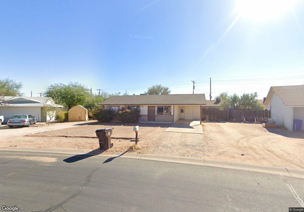
415 N 111th St Mesa, AZ 85207
Northeast Mesa NeighborhoodEstimated Value: $256,910 - $334,000
3
Beds
2
Baths
926
Sq Ft
$335/Sq Ft
Est. Value
About This Home
This home is located at 415 N 111th St, Mesa, AZ 85207 and is currently estimated at $309,978, approximately $334 per square foot. 415 N 111th St is a home located in Maricopa County with nearby schools including Sousa Elementary School, Franklin at Brimhall Elementary School, and Franklin West Elementary School.
Ownership History
Date
Name
Owned For
Owner Type
Purchase Details
Closed on
Nov 28, 2012
Sold by
Demaria Fred and Demaria Melanie
Bought by
Demaria Fred and Demaria Melanie
Current Estimated Value
Purchase Details
Closed on
Jul 22, 1997
Sold by
Mccawley Joseph P and Mccawley Anne B
Bought by
Bennett Franklin L
Home Financials for this Owner
Home Financials are based on the most recent Mortgage that was taken out on this home.
Original Mortgage
$45,800
Outstanding Balance
$6,604
Interest Rate
7.57%
Estimated Equity
$303,374
Purchase Details
Closed on
Mar 5, 1997
Sold by
Incisive Investments Llc
Bought by
Mccawley Anne B and Bennett Anne B
Create a Home Valuation Report for This Property
The Home Valuation Report is an in-depth analysis detailing your home's value as well as a comparison with similar homes in the area
Home Values in the Area
Average Home Value in this Area
Purchase History
| Date | Buyer | Sale Price | Title Company |
|---|---|---|---|
| Demaria Fred | -- | Clear Title Agency Of Arizon | |
| Bennett Franklin L | -- | Chicago Title Insurance Co | |
| Mccawley Anne B | -- | -- |
Source: Public Records
Mortgage History
| Date | Status | Borrower | Loan Amount |
|---|---|---|---|
| Open | Bennett Franklin L | $45,800 |
Source: Public Records
Tax History Compared to Growth
Tax History
| Year | Tax Paid | Tax Assessment Tax Assessment Total Assessment is a certain percentage of the fair market value that is determined by local assessors to be the total taxable value of land and additions on the property. | Land | Improvement |
|---|---|---|---|---|
| 2025 | $683 | $7,582 | -- | -- |
| 2024 | $691 | $7,221 | -- | -- |
| 2023 | $691 | $23,080 | $4,610 | $18,470 |
| 2022 | $675 | $17,130 | $3,420 | $13,710 |
| 2021 | $673 | $15,230 | $3,040 | $12,190 |
| 2020 | $668 | $13,050 | $2,610 | $10,440 |
| 2019 | $619 | $12,080 | $2,410 | $9,670 |
| 2018 | $603 | $10,870 | $2,170 | $8,700 |
| 2017 | $582 | $9,300 | $1,860 | $7,440 |
| 2016 | $570 | $8,150 | $1,630 | $6,520 |
| 2015 | $533 | $6,410 | $1,280 | $5,130 |
Source: Public Records
Map
Nearby Homes
- 11020 E University Dr
- 11101 E University Dr Unit 214
- 11101 E University Dr Unit 171
- 11101 E University Dr Unit 125
- 433 N 111th Place
- 315 N Keith St
- 11121 E Camino Cir
- 345 N Signal Butte Rd Unit 23
- 11201 E Jupiter Dr
- 456 N Opal
- 11232 E Dover St
- 138 N Signal Butte Rd
- 11252 E Boise St
- 634 N Signal Butte Rd
- 11340 E Caballero St
- 11345 E Camino St
- 813 N 110th St
- 53 N Mountain Rd Unit 19
- 11100 E Apache Trail Unit 26
- 11100 E Apache Trail Unit 8
- 409 N 111th St
- 421 N 111th St
- 421 N 111th St
- 409 N 111th St
- 11016 E University Dr
- 11016 E University Dr Unit 1-2
- 11016 E University Dr Unit 1
- 11010 E University Dr
- 11010 E University Dr Unit 1-2
- 401 N 111th St
- 412 N 111th St
- 425 N 111th St
- 11026 E University Dr
- 11002 E University Dr
- 11002 E University Dr Unit 1-2
- 11032 E University Dr
- 426 N 111th St
- 437 N 110th St
- 11109 E Collar Cir
- 429 N 111th St