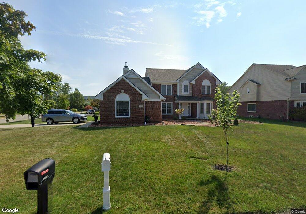
41517 Singh Dr Canton, MI 48188
Estimated Value: $503,000 - $593,000
--
Bed
3
Baths
2,709
Sq Ft
$204/Sq Ft
Est. Value
About This Home
This home is located at 41517 Singh Dr, Canton, MI 48188 and is currently estimated at $551,936, approximately $203 per square foot. 41517 Singh Dr is a home located in Wayne County with nearby schools including Canton High School, Salem High School, and Plymouth High School.
Ownership History
Date
Name
Owned For
Owner Type
Purchase Details
Closed on
Oct 13, 2006
Sold by
Baker Frederick L and Baker Susan K
Bought by
Kaur Sumanjit
Current Estimated Value
Purchase Details
Closed on
Apr 20, 2001
Sold by
Singh Homes Llc
Bought by
Baker Frederick L
Home Financials for this Owner
Home Financials are based on the most recent Mortgage that was taken out on this home.
Original Mortgage
$249,600
Interest Rate
6.8%
Create a Home Valuation Report for This Property
The Home Valuation Report is an in-depth analysis detailing your home's value as well as a comparison with similar homes in the area
Home Values in the Area
Average Home Value in this Area
Purchase History
| Date | Buyer | Sale Price | Title Company |
|---|---|---|---|
| Kaur Sumanjit | $312,500 | Old Republic Title Co | |
| Baker Frederick L | -- | -- | |
| Singh Homes Llc | -- | -- |
Source: Public Records
Mortgage History
| Date | Status | Borrower | Loan Amount |
|---|---|---|---|
| Previous Owner | Singh Homes Llc | $249,600 |
Source: Public Records
Tax History Compared to Growth
Tax History
| Year | Tax Paid | Tax Assessment Tax Assessment Total Assessment is a certain percentage of the fair market value that is determined by local assessors to be the total taxable value of land and additions on the property. | Land | Improvement |
|---|---|---|---|---|
| 2025 | $3,265 | $249,100 | $0 | $0 |
| 2024 | $3,265 | $250,300 | $0 | $0 |
| 2023 | $3,112 | $226,500 | $0 | $0 |
| 2022 | $6,736 | $200,900 | $0 | $0 |
| 2021 | $6,552 | $193,600 | $0 | $0 |
| 2020 | $6,458 | $194,600 | $0 | $0 |
| 2019 | $6,338 | $181,420 | $0 | $0 |
| 2018 | $2,645 | $178,330 | $0 | $0 |
| 2017 | $6,389 | $176,800 | $0 | $0 |
| 2016 | $5,756 | $179,700 | $0 | $0 |
| 2015 | $14,535 | $158,840 | $0 | $0 |
| 2013 | $14,084 | $146,690 | $0 | $0 |
| 2010 | -- | $131,710 | $72,657 | $59,053 |
Source: Public Records
Map
Nearby Homes
- 2435 S Haggerty Rd
- 2340 S Lilley Rd
- 2006 S Lilley Rd
- 2855 Tall Oak Ln
- 000 S Lotz Rd
- 2322 Arcadia Dr Unit 254
- 41481 Cumberland Dr
- 41441 Cumberland Dr
- 2942 Tall Oak Ln
- 1803 Pinecroft Dr Unit 171
- 40488 Glen Eagle Ln Unit 75
- 41928 Old Bridge Rd
- 2098 Preserve Cir W Unit 80
- 50519 Rockingham Dr
- 41021 Old Michigan Ave
- 41021 Lot 46 Old Michigan Ave
- 1530 Fairfax Dr
- 1913 Pebble Creek Dr
- 1834 Maple Park Dr W Unit 9
- 40012 Michigan Ave
- 41543 Singh Dr
- 2660 Woodsboro Ct
- 41569 Singh Dr
- 2649 Woodsboro Ct
- 41530 Singh Dr
- 2670 Woodsboro Ct
- 2659 Woodsboro Ct
- 41478 Singh Dr
- 2661 Emily Ct
- 41556 Singh Dr
- 2669 Woodsboro Ct
- 41595 Singh Dr
- 41452 Singh Dr
- 41582 Singh Dr
- 2671 Emily Ct
- 2372 Monument Ln
- 41426 Singh Dr
- 41608 Singh Dr
- 41634 Singh Dr
- 2662 Emily Ct