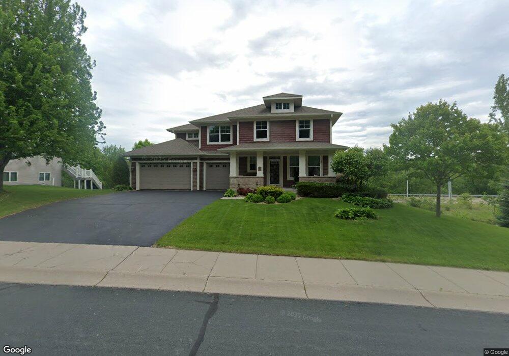
4160 Maple Hurst Dr N Rockford, MN 55373
Estimated Value: $561,876 - $604,000
4
Beds
3
Baths
2,920
Sq Ft
$200/Sq Ft
Est. Value
About This Home
This home is located at 4160 Maple Hurst Dr N, Rockford, MN 55373 and is currently estimated at $583,469, approximately $199 per square foot. 4160 Maple Hurst Dr N is a home located in Wright County with nearby schools including Rockford Elementary Arts Magnet School, Rockford Middle School - Center for Environmental Studies, and Rockford High School.
Ownership History
Date
Name
Owned For
Owner Type
Purchase Details
Closed on
Aug 11, 2009
Sold by
U S Home Corporation
Bought by
Fagerhaugh Charles J and Fagerhaugh Peggy E
Current Estimated Value
Purchase Details
Closed on
Jul 31, 2009
Sold by
U S Home Corporation
Bought by
Fagerhaugh Charles J and Fagerhaugh Peggy E
Purchase Details
Closed on
Dec 22, 2006
Sold by
Dauel A Fare Development Corp
Bought by
Us Home Corp
Create a Home Valuation Report for This Property
The Home Valuation Report is an in-depth analysis detailing your home's value as well as a comparison with similar homes in the area
Home Values in the Area
Average Home Value in this Area
Purchase History
| Date | Buyer | Sale Price | Title Company |
|---|---|---|---|
| Fagerhaugh Charles J | -- | -- | |
| Fagerhaugh Charles J | -- | -- | |
| Us Home Corp | $2,592,000 | -- |
Source: Public Records
Tax History Compared to Growth
Tax History
| Year | Tax Paid | Tax Assessment Tax Assessment Total Assessment is a certain percentage of the fair market value that is determined by local assessors to be the total taxable value of land and additions on the property. | Land | Improvement |
|---|---|---|---|---|
| 2025 | $5,898 | $506,100 | $90,000 | $416,100 |
| 2024 | $5,828 | $506,000 | $90,000 | $416,000 |
| 2023 | $5,764 | $513,700 | $90,000 | $423,700 |
| 2022 | $5,744 | $455,900 | $85,000 | $370,900 |
| 2021 | $6,020 | $403,600 | $70,000 | $333,600 |
| 2020 | $6,240 | $412,900 | $70,000 | $342,900 |
| 2019 | $6,388 | $402,300 | $0 | $0 |
| 2018 | $5,520 | $396,000 | $0 | $0 |
| 2017 | $5,110 | $367,100 | $0 | $0 |
| 2016 | $4,968 | $0 | $0 | $0 |
| 2015 | $5,014 | $0 | $0 | $0 |
| 2014 | -- | $0 | $0 | $0 |
Source: Public Records
Map
Nearby Homes
- 4231 Maple Hurst Dr N
- 4090 Maple Hurst Dr S
- XXX Jansen Ave SE
- 4040 Maple Hurst Dr S
- 8530 Fir St
- 7021 Meadow Ct
- 6761 Maple Dr
- 6630 Maple Dr
- 8130 Ravenrock Rd
- 8800 86th Ave N
- 8098 26th St SE
- 8041 Prairie Trail
- 3439 Hall Ave SE
- 7040 Winfield Rd
- 6101 Boulder Ridge Dr
- 8833 Walnut Place
- The Madison Plan at Kettering Creek - Kettering Creek Villas
- The Windsor Villa Plan at Kettering Creek - Kettering Creek Villas
- The Windsor Plan at Kettering Creek - Kettering Creek Villas
- The Madison Villa Plan at Kettering Creek - Kettering Creek Villas
- 4160 Maple Hurst Dr N
- 4170 4170 Maple Hurst Dr N
- 4170 Maple Hurst Dr N
- 4170 Maple Hurst Dr Dr N
- 3007 Red Maple Ct
- 3007 3007 Red Maple Ct N
- 3007 Red Maple Ct N
- 3009 Red Maple Ct
- 3009 3009 Red Maple Ct N
- 3009 3009 Red Maple-Court-n
- 4171 Maple Hurst Dr N
- 4171 4171 Maple Hurst-Drive-n
- 4171 4171 Maple Hurst Dr N
- 3009 Red Maple Ct N
- 3011 Red Maple Ct N
- 3011 Red Maple Ct
- 3011 3011 Red Maple-Court-n
- 3011 3011 Red Maple Ct N
- 4181 4181 Maple Hurst-Drive-n
- 4181 4181 Maple Hurst Dr N