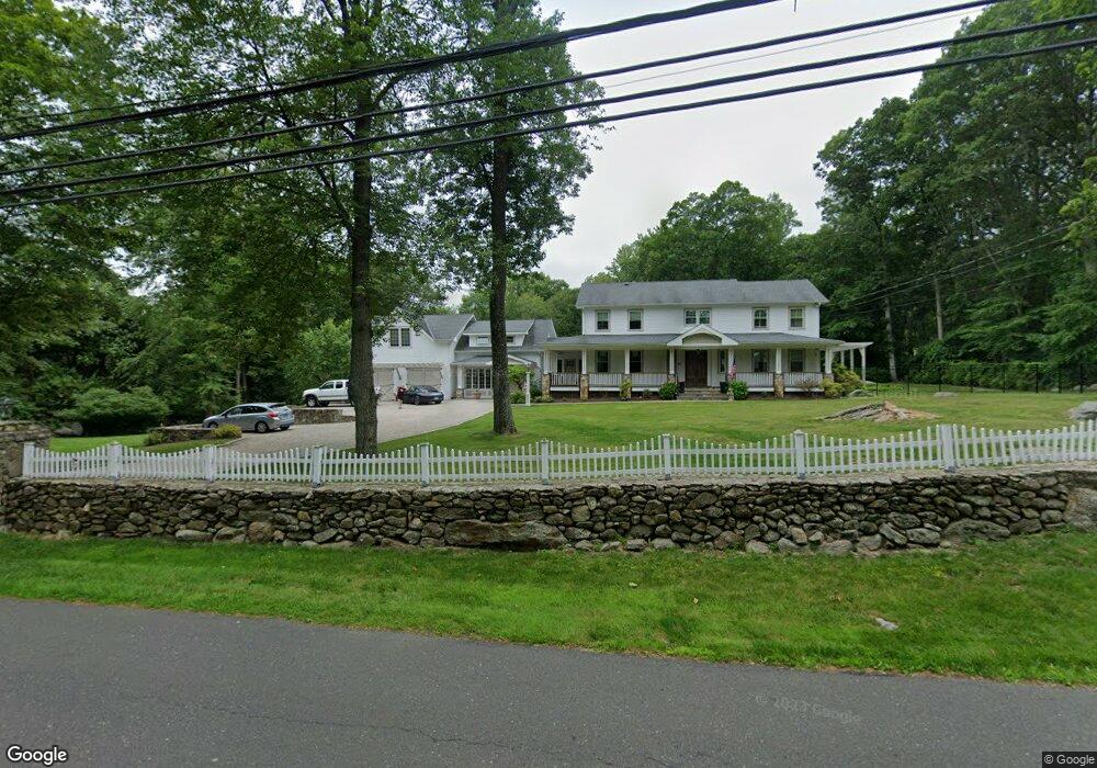
417 Erskine Rd Stamford, CT 06903
North Stamford NeighborhoodEstimated Value: $1,526,551 - $1,919,000
5
Beds
4
Baths
4,469
Sq Ft
$367/Sq Ft
Est. Value
About This Home
This home is located at 417 Erskine Rd, Stamford, CT 06903 and is currently estimated at $1,639,638, approximately $366 per square foot. 417 Erskine Rd is a home located in Fairfield County with nearby schools including Roxbury School, Cloonan School, and Westhill High School.
Ownership History
Date
Name
Owned For
Owner Type
Purchase Details
Closed on
Mar 2, 2005
Sold by
Utter David W
Bought by
Dolger Jason and Leonard Monica
Current Estimated Value
Home Financials for this Owner
Home Financials are based on the most recent Mortgage that was taken out on this home.
Original Mortgage
$996,000
Outstanding Balance
$484,416
Interest Rate
5%
Estimated Equity
$1,155,222
Purchase Details
Closed on
Feb 24, 1993
Sold by
Brewer Robert
Bought by
Utter David and Utter Lori
Home Financials for this Owner
Home Financials are based on the most recent Mortgage that was taken out on this home.
Original Mortgage
$500,000
Interest Rate
4.88%
Mortgage Type
Unknown
Purchase Details
Closed on
Apr 15, 1987
Sold by
Lewis Ronald
Bought by
Brewer Robert
Create a Home Valuation Report for This Property
The Home Valuation Report is an in-depth analysis detailing your home's value as well as a comparison with similar homes in the area
Home Values in the Area
Average Home Value in this Area
Purchase History
| Date | Buyer | Sale Price | Title Company |
|---|---|---|---|
| Dolger Jason | $1,245,000 | -- | |
| Utter David | $850,000 | -- | |
| Brewer Robert | $575,000 | -- |
Source: Public Records
Mortgage History
| Date | Status | Borrower | Loan Amount |
|---|---|---|---|
| Open | Brewer Robert | $100,000 | |
| Open | Brewer Robert | $996,000 | |
| Closed | Brewer Robert | $1,000,000 | |
| Previous Owner | Brewer Robert | $500,000 |
Source: Public Records
Tax History Compared to Growth
Tax History
| Year | Tax Paid | Tax Assessment Tax Assessment Total Assessment is a certain percentage of the fair market value that is determined by local assessors to be the total taxable value of land and additions on the property. | Land | Improvement |
|---|---|---|---|---|
| 2025 | $19,192 | $824,740 | $301,510 | $523,230 |
| 2024 | $18,771 | $824,740 | $301,510 | $523,230 |
| 2023 | $20,173 | $824,740 | $301,510 | $523,230 |
| 2022 | $17,797 | $675,930 | $229,200 | $446,730 |
| 2021 | $17,554 | $675,930 | $229,200 | $446,730 |
| 2020 | $17,121 | $675,930 | $229,200 | $446,730 |
| 2019 | $17,121 | $675,930 | $229,200 | $446,730 |
| 2018 | $16,526 | $675,930 | $229,200 | $446,730 |
| 2017 | $17,271 | $674,920 | $257,060 | $417,860 |
| 2016 | $16,752 | $674,920 | $257,060 | $417,860 |
| 2015 | $16,293 | $674,920 | $257,060 | $417,860 |
| 2014 | $15,732 | $674,920 | $257,060 | $417,860 |
Source: Public Records
Map
Nearby Homes
- 21 S Brook Dr
- Lot #21 S Brook Dr
- Lot #5 S Brook Dr
- 0 S Brook Dr Unit 170552650
- 110 Erskine Rd
- 401 Wildwood Rd
- 43 Mill Rd
- 11 Fox Glen Dr
- 71 N Lake Dr
- 139 Echo Hill Dr
- 40 Wildwood Rd
- 279 E Middle Patent Rd
- 555 Haviland Rd
- 271 Hunting Ridge Rd
- 1287 Rock Rimmon Rd
- 21 Easthill Rd
- 22 Blackberry Dr E
- 81 Fox Ridge Rd
- 125 Saddle Hill Rd
- 391 Sawmill Rd
- 0 Erskine Rd
- 346466 Erskine Rd
- 389 Erskine Rd
- 385 Erskine Rd
- 416 Erskine Rd
- 103 Jonathan Dr
- 81 Jonathan Dr
- 383 Erskine Rd
- 396 Erskine Rd
- 125 Jonathan Dr
- 55 Jonathan Dr
- 375 Erskine Rd
- 131 Jonathan Dr
- 316 Erskine Rd
- 25 Jonathan Dr
- 28 Laurel Ledge Ct
- 483 Erskine Rd
- 18 Laurel Ledge Ct
- 90 Jonathan Dr
- 135 Jonathan Dr