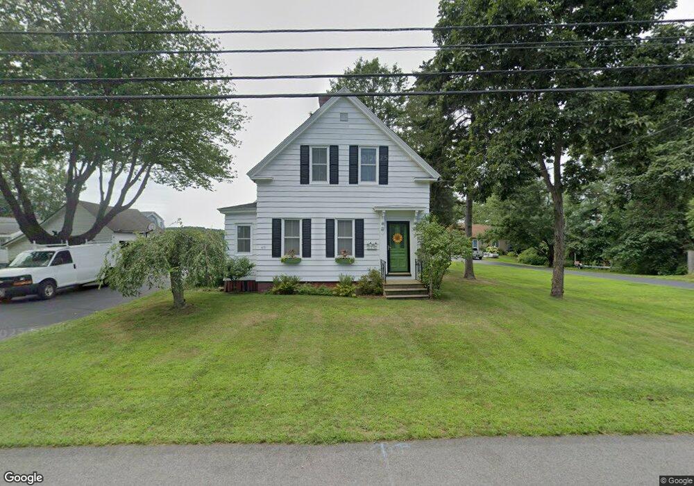
419 Dover Point Rd Dover, NH 03820
Dover Point NeighborhoodEstimated Value: $878,000 - $999,000
4
Beds
2
Baths
1,973
Sq Ft
$472/Sq Ft
Est. Value
About This Home
This home is located at 419 Dover Point Rd, Dover, NH 03820 and is currently estimated at $931,829, approximately $472 per square foot. 419 Dover Point Rd is a home located in Strafford County with nearby schools including Garrison School, Dover Middle School, and Dover Senior High School.
Ownership History
Date
Name
Owned For
Owner Type
Purchase Details
Closed on
Oct 29, 2024
Sold by
Shine Ann L
Bought by
L Shine A
Current Estimated Value
Purchase Details
Closed on
Nov 20, 2018
Sold by
Shine Ann
Bought by
Blackwell John and Blackwell Sharon
Create a Home Valuation Report for This Property
The Home Valuation Report is an in-depth analysis detailing your home's value as well as a comparison with similar homes in the area
Home Values in the Area
Average Home Value in this Area
Purchase History
| Date | Buyer | Sale Price | Title Company |
|---|---|---|---|
| L Shine A | -- | None Available | |
| Blackwell John | -- | -- | |
| Shine Ann | -- | -- | |
| Blackwell John | -- | -- |
Source: Public Records
Tax History
| Year | Tax Paid | Tax Assessment Tax Assessment Total Assessment is a certain percentage of the fair market value that is determined by local assessors to be the total taxable value of land and additions on the property. | Land | Improvement |
|---|---|---|---|---|
| 2024 | $15,942 | $877,400 | $531,800 | $345,600 |
| 2023 | $13,875 | $742,000 | $438,100 | $303,900 |
| 2022 | $13,388 | $674,800 | $400,600 | $274,200 |
| 2021 | $12,855 | $592,400 | $353,800 | $238,600 |
| 2020 | $12,825 | $516,100 | $320,800 | $195,300 |
| 2019 | $11,935 | $473,800 | $290,600 | $183,200 |
| 2018 | $11,324 | $454,400 | $277,200 | $177,200 |
| 2017 | $11,336 | $438,200 | $266,100 | $172,100 |
| 2016 | $11,347 | $431,600 | $275,100 | $156,500 |
| 2015 | $11,386 | $427,900 | $275,100 | $152,800 |
| 2014 | $11,546 | $443,900 | $275,100 | $168,800 |
| 2011 | $11,063 | $440,400 | $275,100 | $165,300 |
Source: Public Records
Map
Nearby Homes
- 18 Little Bay Dr
- 354 Dover Point Rd
- 348 Dover Point Rd
- 0 Cote Dr Unit 55B
- 71 Shipwright Way
- 18 Deborah Ln
- 41 Clearwater Dr
- 10 Shipwright Way
- Slip B18 Little Bay
- 0 Franks Fort Island Unit 1650383
- 708 River Rd Unit 2
- 708 River Rd Unit 3
- 18 Governor Hill Rd
- 11 Willey Creek Rd
- 1708 State Rd
- 25 Fosters Dr
- 18 Shipping Ln
- 10 Pasture Hill Dr
- Lot 2 Cedar Tbd
- 1128 State Rd
- 419A Dover Point Rd
- 423 Dover Point Rd
- 15 Little Bay Dr
- 9 Little Bay Dr Unit 9
- 38 Little Bay Dr Unit 38
- 3 Little Bay Dr Unit 3
- 15 Little Bay Dr Unit 15
- 18 Little Bay Dr Unit 18
- 17 Little Bay Dr Unit 17
- 417 Dover Point Rd
- 415 Dover Point Rd
- 421 Dover Point Rd
- 427 Dover Point Rd
- 425 Dover Point Rd
- 33 Little Bay Dr Unit MLU 33
- 33 Little Bay Dr
- SLIP 15 Little Bay Marina
- 416 Dover Point Rd
- 418 Dover Point Rd
- 413 Dover Point Rd
Your Personal Tour Guide
Ask me questions while you tour the home.