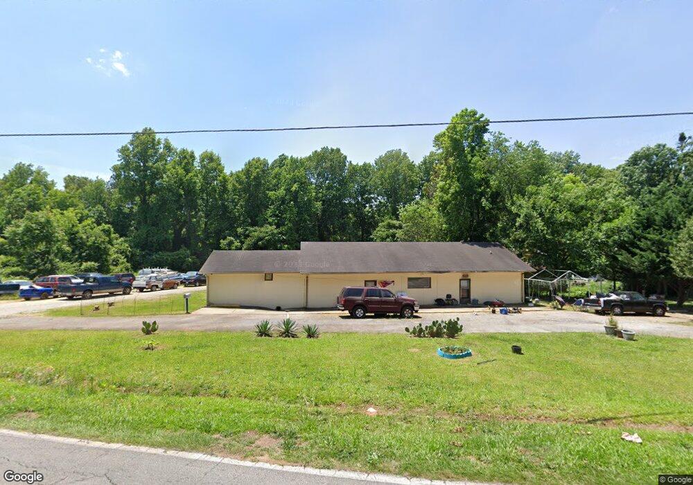
419 Lewis St Anderson, SC 29624
Estimated Value: $85,164
2
Beds
1
Bath
2,680
Sq Ft
$32/Sq Ft
Est. Value
About This Home
This home is located at 419 Lewis St, Anderson, SC 29624 and is currently estimated at $85,164, approximately $31 per square foot. 419 Lewis St is a home located in Anderson County with nearby schools including Varennes Elementary School, Robert Anderson Middle School, and Westside High School.
Ownership History
Date
Name
Owned For
Owner Type
Purchase Details
Closed on
Oct 8, 2024
Sold by
Breakout Properties Llc
Bought by
Wickware Christopher C
Current Estimated Value
Purchase Details
Closed on
Feb 29, 2024
Sold by
Crawford Charles
Bought by
Breakout Properties Llc
Purchase Details
Closed on
Feb 28, 2024
Sold by
English Shelby Elese
Bought by
Crawford Charles
Purchase Details
Closed on
Nov 10, 2005
Sold by
Mitchell Shelby E
Bought by
English Shelby Elese
Purchase Details
Closed on
Aug 12, 2005
Sold by
Mitchell Winford
Bought by
Mitchell Shelby E
Purchase Details
Closed on
Jul 25, 2005
Sold by
Mitchell Winford
Bought by
Mitchell Shelby
Create a Home Valuation Report for This Property
The Home Valuation Report is an in-depth analysis detailing your home's value as well as a comparison with similar homes in the area
Home Values in the Area
Average Home Value in this Area
Purchase History
| Date | Buyer | Sale Price | Title Company |
|---|---|---|---|
| Wickware Christopher C | $8,000 | None Listed On Document | |
| Breakout Properties Llc | $45,000 | South Carolina Title | |
| Crawford Charles | $60,000 | None Listed On Document | |
| English Shelby Elese | -- | -- | |
| Mitchell Shelby E | -- | -- | |
| Mitchell Shelby | -- | -- |
Source: Public Records
Tax History Compared to Growth
Tax History
| Year | Tax Paid | Tax Assessment Tax Assessment Total Assessment is a certain percentage of the fair market value that is determined by local assessors to be the total taxable value of land and additions on the property. | Land | Improvement |
|---|---|---|---|---|
| 2024 | $1,314 | $4,850 | $1,550 | $3,300 |
| 2023 | $1,314 | $4,850 | $1,550 | $3,300 |
| 2022 | $1,397 | $5,340 | $1,550 | $3,790 |
| 2021 | $1,263 | $4,740 | $1,550 | $3,190 |
| 2020 | $1,245 | $4,740 | $1,550 | $3,190 |
| 2019 | $1,245 | $4,740 | $1,550 | $3,190 |
| 2018 | $1,229 | $4,740 | $1,550 | $3,190 |
| 2017 | -- | $4,740 | $1,550 | $3,190 |
| 2016 | $1,076 | $4,280 | $1,420 | $2,860 |
| 2015 | $1,088 | $4,280 | $1,420 | $2,860 |
| 2014 | $1,072 | $4,280 | $1,420 | $2,860 |
Source: Public Records
Map
Nearby Homes
- 431 Lewis St
- 505 Lewis St
- 612 Martha Dr
- 114 Hillcrest Cir Unit A
- 114 Hillcrest Cir
- 112 Flowe Rd
- 222 Hillcrest Cir
- 719 Dora Dr
- 701 Delia St
- 701 Delia St Unit B
- 701 Delia St Unit A
- 00 Ila St
- 00 Hwy 28 Bypass New Pond Rd
- 720 722 Gary St
- 1105 W Franklin St
- 1103 Scott Dr
- 00 W Franklin St
- 0 W Franklin St
- 3308 New Pond Rd
- 0 W Reed St