Estimated Value: $129,172 - $158,000
2
Beds
1
Bath
1,027
Sq Ft
$137/Sq Ft
Est. Value
About This Home
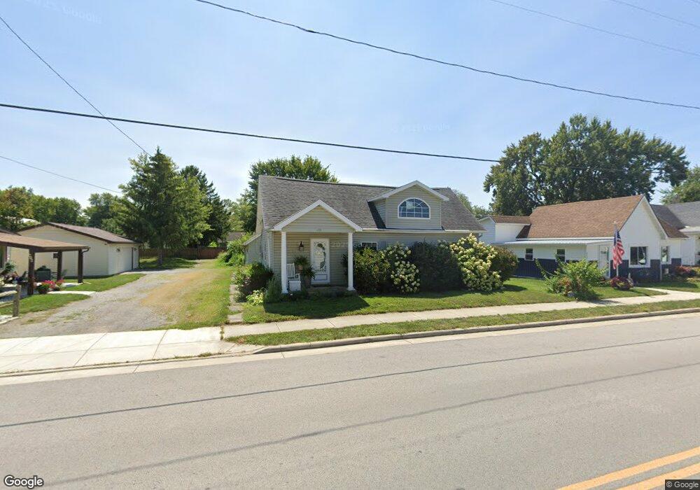
This home is located at 419 W Main St, Cairo, OH 45820 and is currently estimated at $141,043, approximately $137 per square foot. 419 W Main St is a home located in Allen County with nearby schools including Bath Elementary School, Bath Middle School, and Bath High School.
Ownership History
Date
Name
Owned For
Owner Type
Purchase Details
Closed on
Jul 26, 2007
Sold by
Tudor Robert O
Bought by
Miller Robin A
Current Estimated Value
Home Financials for this Owner
Home Financials are based on the most recent Mortgage that was taken out on this home.
Original Mortgage
$63,200
Outstanding Balance
$40,117
Interest Rate
6.71%
Mortgage Type
New Conventional
Estimated Equity
$100,926
Purchase Details
Closed on
Aug 25, 2006
Sold by
Gutman Angela D
Bought by
Tudor Robert O
Home Financials for this Owner
Home Financials are based on the most recent Mortgage that was taken out on this home.
Original Mortgage
$66,400
Interest Rate
6.78%
Mortgage Type
New Conventional
Purchase Details
Closed on
Oct 14, 1997
Sold by
Est Emma Michael
Bought by
Hirsch Dennis and Hirsch Molly
Home Financials for this Owner
Home Financials are based on the most recent Mortgage that was taken out on this home.
Original Mortgage
$17,500
Interest Rate
7.7%
Mortgage Type
New Conventional
Purchase Details
Closed on
Nov 30, 1988
Bought by
Michael Emma F
Create a Home Valuation Report for This Property
The Home Valuation Report is an in-depth analysis detailing your home's value as well as a comparison with similar homes in the area
Purchase History
| Date | Buyer | Sale Price | Title Company |
|---|---|---|---|
| Miller Robin A | $79,000 | None Available | |
| Tudor Robert O | $83,000 | None Available | |
| Hirsch Dennis | $22,000 | -- | |
| Michael Emma F | $37,000 | -- |
Source: Public Records
Mortgage History
| Date | Status | Borrower | Loan Amount |
|---|---|---|---|
| Open | Miller Robin A | $63,200 | |
| Previous Owner | Tudor Robert O | $66,400 | |
| Previous Owner | Hirsch Dennis | $17,500 |
Source: Public Records
Tax History
| Year | Tax Paid | Tax Assessment Tax Assessment Total Assessment is a certain percentage of the fair market value that is determined by local assessors to be the total taxable value of land and additions on the property. | Land | Improvement |
|---|---|---|---|---|
| 2024 | $1,463 | $35,110 | $3,570 | $31,540 |
| 2023 | $1,175 | $24,890 | $2,520 | $22,370 |
| 2022 | $1,181 | $24,890 | $2,520 | $22,370 |
| 2021 | $1,177 | $24,890 | $2,520 | $22,370 |
| 2020 | $1,111 | $21,500 | $2,420 | $19,080 |
| 2019 | $1,111 | $21,500 | $2,420 | $19,080 |
| 2018 | $1,086 | $21,500 | $2,420 | $19,080 |
| 2017 | $990 | $19,430 | $2,420 | $17,010 |
| 2016 | $975 | $19,430 | $2,420 | $17,010 |
| 2015 | $1,045 | $19,430 | $2,420 | $17,010 |
| 2014 | $1,045 | $20,240 | $2,280 | $17,960 |
| 2013 | $1,046 | $20,240 | $2,280 | $17,960 |
Source: Public Records
Map
Nearby Homes
- 513 W Main St
- 201 Wall St
- 102 W Main St
- 634 W Main St
- 1085 Lutz Rd
- 4387 N West St
- 0 Fraunfelter Unit 307817
- 0 N Eastown Rd Unit 1034495
- 3263 Shiloh Dr
- 0 Thorndyke Dr
- 3137 Thorndyke Dr
- 2878 Autumn Lake Dr
- 475 Kenmore St
- 520 Kenmore St
- 0 N Dixie Hwy Unit 300253
- 2718 Carolyn Dr
- 8170 Sandy Point Rd
- 2630 Carolyn Dr
- 11059 Ottawa Rd
- 2380 Mandolin Dr
Your Personal Tour Guide
Ask me questions while you tour the home.