


42 Alsun Dr Hollis, NH 03049
Hollis NeighborhoodEstimated payment $6,192/month
Highlights
- Cape Cod Architecture
- Deck
- Wood Flooring
- Hollis Primary School Rated A
- Cathedral Ceiling
- Sun or Florida Room
About This Home
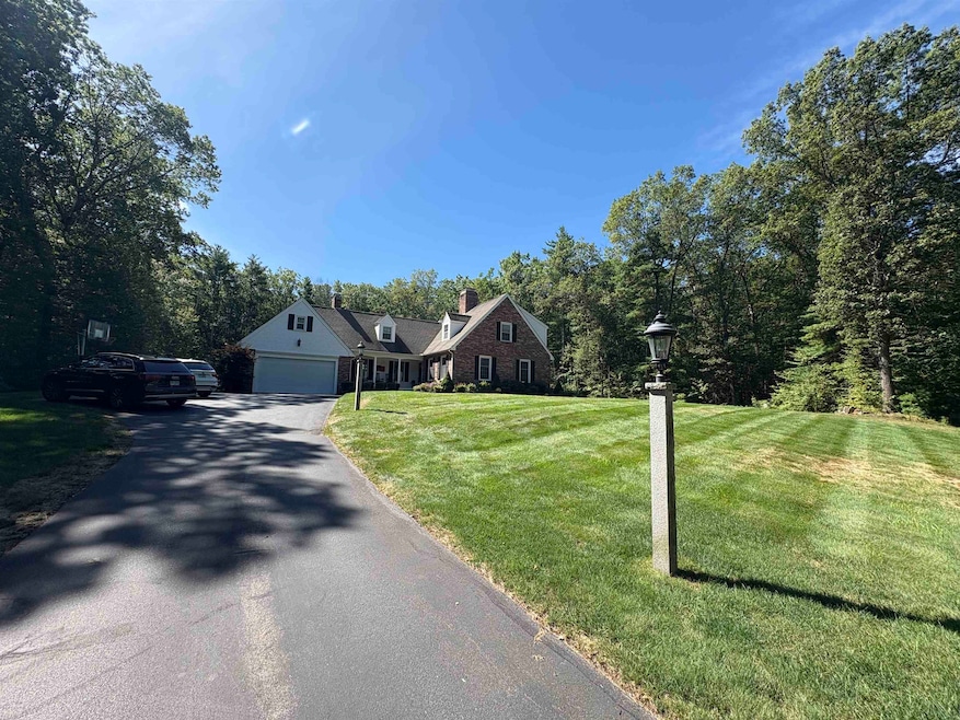
Magically situated on a lovely 2.18 acre manicured parcel, this impeccably maintained custom brick front cape offers the discerning buyer every possible option.Rolling manicured lawns surround this lovely home situated on a sleepy Hollis NH cul de sac.The first level offers a spacious fireplaced family room leading to a four season sun room offering direct access to the oversized rear deck leading to the pool and yards of level manicured rear lawn area.,a fireplaced formal living room, formal dining room, updated kitchen replete with updated stainless appliances and yards of granite and custom cherry cabinetry and eat in capacity all leading to a secondary 3 season porch with access to a lower stone terrace perfect for grilling and outdoor seating.A fireplaced great room with deck access and private office and powder room.The second level offers four spacious bedrooms.The primary suite is a dream, offering a wood burning fireplace, substantial walk in closet /dressing room, spa like bath with custom shower.The guest bedrooms are spacious and serviced by a thoughtful full bath.The lower level offers a partially finished area and plenty of unfinished areas for storage.This property awaits your viewing, beautiful finished throughout-hardwood floor, neutral colors throughout, central air,4 fireplaces, partially finished basement, heirloom landscaping all add to this beauty.Years of pride of ownership show throughout this property awaiting your viewing.
Home Details
Home Type
- Single Family
Est. Annual Taxes
- $14,796
Year Built
- Built in 1981
Lot Details
- 2.18 Acre Lot
- Property fronts a private road
- Property is zoned RA
Parking
- 2 Car Garage
Home Design
- Cape Cod Architecture
- Concrete Foundation
- Wood Frame Construction
Interior Spaces
- Property has 2 Levels
- Bar
- Cathedral Ceiling
- Ceiling Fan
- Skylights
- Fireplace
- Natural Light
- Great Room
- Family Room
- Living Room
- Dining Room
- Den
- Sun or Florida Room
- Utility Room
Kitchen
- Gas Range
- Microwave
- Dishwasher
Flooring
- Wood
- Carpet
- Ceramic Tile
Bedrooms and Bathrooms
- 4 Bedrooms
- En-Suite Primary Bedroom
- En-Suite Bathroom
- Walk-In Closet
Laundry
- Dryer
- Washer
Basement
- Walk-Out Basement
- Basement Fills Entire Space Under The House
- Interior Basement Entry
Outdoor Features
- Deck
- Porch
Schools
- Hollis Upper Elementary School
- Hollis Brookline Middle Sch
- Hollis-Brookline High School
Utilities
- Central Air
- Baseboard Heating
- Hot Water Heating System
- Power Generator
- Private Water Source
- Drilled Well
- Leach Field
- Cable TV Available
Listing and Financial Details
- Tax Lot 026
- Assessor Parcel Number 046
Map
Home Values in the Area
Average Home Value in this Area
Tax History
| Year | Tax Paid | Tax Assessment Tax Assessment Total Assessment is a certain percentage of the fair market value that is determined by local assessors to be the total taxable value of land and additions on the property. | Land | Improvement |
|---|---|---|---|---|
| 2024 | $14,796 | $834,500 | $355,000 | $479,500 |
| 2023 | $13,803 | $828,500 | $355,000 | $473,500 |
| 2022 | $18,699 | $828,500 | $355,000 | $473,500 |
| 2021 | $10,664 | $469,800 | $181,900 | $287,900 |
| 2020 | $5,383 | $469,800 | $181,900 | $287,900 |
| 2019 | $5,309 | $469,800 | $181,900 | $287,900 |
| 2018 | $5,169 | $469,800 | $181,900 | $287,900 |
| 2017 | $10,042 | $433,800 | $157,300 | $276,500 |
| 2016 | $10,820 | $461,800 | $157,300 | $304,500 |
| 2015 | $10,631 | $461,800 | $157,300 | $304,500 |
| 2014 | $10,681 | $461,800 | $157,300 | $304,500 |
| 2013 | $10,552 | $462,400 | $157,300 | $305,100 |
Property History
| Date | Event | Price | Change | Sq Ft Price |
|---|---|---|---|---|
| 08/18/2025 08/18/25 | For Sale | $939,000 | -- | $228 / Sq Ft |
Purchase History
| Date | Type | Sale Price | Title Company |
|---|---|---|---|
| Warranty Deed | $440,000 | -- |
Mortgage History
| Date | Status | Loan Amount | Loan Type |
|---|---|---|---|
| Open | $200,000 | Stand Alone Refi Refinance Of Original Loan | |
| Closed | $263,000 | Unknown | |
| Open | $2,354,000 | Unknown | |
| Closed | $300,700 | No Value Available |
Source: PrimeMLS
MLS Number: 5057127
APN: HOLS-000046-000000-000026
Disclaimer: Certain information contained herein is derived from information provided by parties other than Homes.com. All information provided is deemed reliable, but is not guaranteed to be accurate and should be independently verified.
![]() Copyright 2025 PrimeMLS, Inc. All rights reserved. This information is deemed reliable, but not guaranteed. The data relating to real estate displayed on this display comes in part from the IDX Program of PrimeMLS. The information being provided is for consumers’ personal, non-commercial use and may not be used for any purpose other than to identify prospective properties consumers may be interested in purchasing.
Copyright 2025 PrimeMLS, Inc. All rights reserved. This information is deemed reliable, but not guaranteed. The data relating to real estate displayed on this display comes in part from the IDX Program of PrimeMLS. The information being provided is for consumers’ personal, non-commercial use and may not be used for any purpose other than to identify prospective properties consumers may be interested in purchasing.
- 43 Alsun Dr
- 206 S Merrimack Rd
- 77 Mooar Hill Rd
- 22 Cobbett Ln
- 5 Pauls Way
- 16 Eastern Ave
- 2 Meadow Ln
- 6 Cub Cir Unit 18
- 7 Shedd Ln
- 464 Boston Post Rd Unit 48
- 1 Tamarack Ln
- 55 Stearns Rd
- 613 Amherst St
- 17 Joey Rd
- 2 Roedean Dr Unit UA304
- 2 New Haven Dr Unit E303
- 45 Long Hill Rd
- 24 Stearns Rd
- 218 Millwright Dr Unit 218
- 148 Nartoff Rd
- 93 Farley Rd
- 2 Roedean Dr Unit 304
- 3 New Haven Dr Unit 203
- 40 Squire Dr
- 27 E Ridge Dr Unit 1
- 29 Capron Rd Unit 33
- 10 E Ridge Dr Unit 304
- 24 Kessler Farm Dr
- 22 Ponemah Hill Rd Unit 6
- 59 Ponemah Hill Rd Unit 1-201
- 486 Nashua St Unit 201
- 95 Powers St Unit 5
- 95 Powers St Unit 105
- 95 Powers St Unit 116
- 95 Powers St Unit 95
- 95 Powers St Unit 20
- 95 Powers St Unit 83
- 90 Powers St
- 307B Amherst St
- 1 Hampshire Dr
