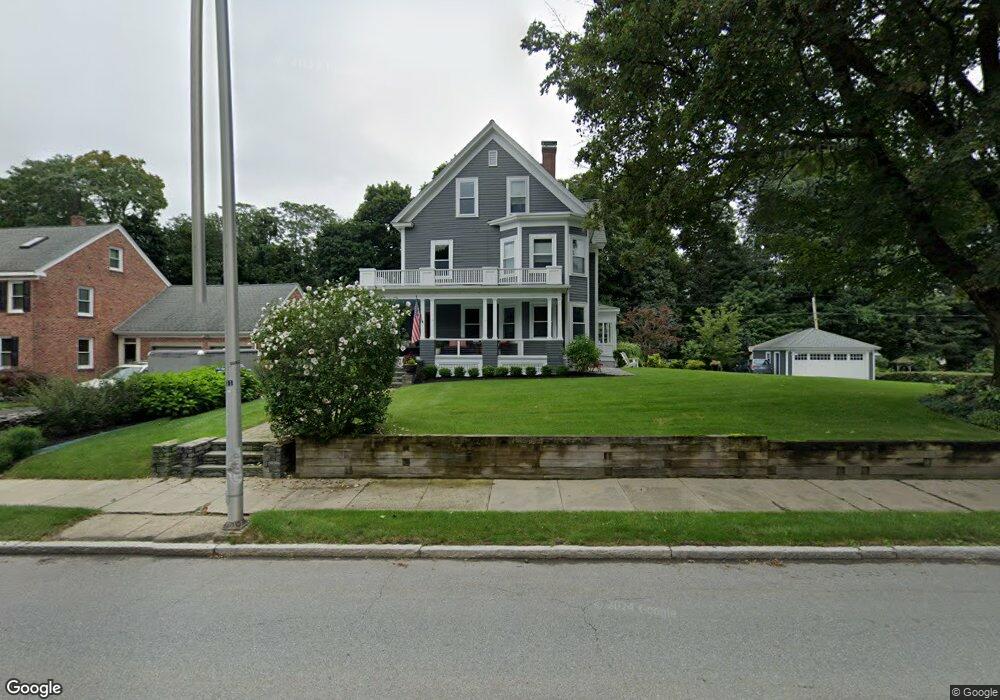
42 Forest St Worcester, MA 01609
Indian Lake East NeighborhoodEstimated Value: $640,000 - $740,000
6
Beds
3
Baths
2,724
Sq Ft
$251/Sq Ft
Est. Value
About This Home
This home is located at 42 Forest St, Worcester, MA 01609 and is currently estimated at $682,723, approximately $250 per square foot. 42 Forest St is a home located in Worcester County with nearby schools including Nelson Place Elementary School, Jacob Hiatt Magnet School, and Chandler Magnet.
Ownership History
Date
Name
Owned For
Owner Type
Purchase Details
Closed on
Jun 3, 2008
Sold by
Rosario Marilyn J and Rosario Samuel
Bought by
Pitcher Sherri L
Current Estimated Value
Home Financials for this Owner
Home Financials are based on the most recent Mortgage that was taken out on this home.
Original Mortgage
$340,000
Outstanding Balance
$216,610
Interest Rate
5.91%
Mortgage Type
Purchase Money Mortgage
Estimated Equity
$466,113
Purchase Details
Closed on
Sep 5, 2003
Sold by
Helen Julia Orr T
Bought by
Rosario Marilyn J and Rosario Samuel
Home Financials for this Owner
Home Financials are based on the most recent Mortgage that was taken out on this home.
Original Mortgage
$308,750
Interest Rate
6.02%
Mortgage Type
Purchase Money Mortgage
Create a Home Valuation Report for This Property
The Home Valuation Report is an in-depth analysis detailing your home's value as well as a comparison with similar homes in the area
Home Values in the Area
Average Home Value in this Area
Purchase History
| Date | Buyer | Sale Price | Title Company |
|---|---|---|---|
| Pitcher Sherri L | $425,000 | -- | |
| Rosario Marilyn J | $325,000 | -- |
Source: Public Records
Mortgage History
| Date | Status | Borrower | Loan Amount |
|---|---|---|---|
| Open | Pitcher Sherri L | $340,000 | |
| Previous Owner | Rosario Marilyn J | $308,750 |
Source: Public Records
Tax History Compared to Growth
Tax History
| Year | Tax Paid | Tax Assessment Tax Assessment Total Assessment is a certain percentage of the fair market value that is determined by local assessors to be the total taxable value of land and additions on the property. | Land | Improvement |
|---|---|---|---|---|
| 2025 | $7,124 | $540,100 | $123,900 | $416,200 |
| 2024 | $6,955 | $505,800 | $123,900 | $381,900 |
| 2023 | $6,698 | $467,100 | $106,700 | $360,400 |
| 2022 | $6,225 | $409,300 | $85,300 | $324,000 |
| 2021 | $6,154 | $378,000 | $68,300 | $309,700 |
| 2020 | $5,942 | $349,500 | $68,100 | $281,400 |
| 2019 | $6,037 | $335,400 | $65,800 | $269,600 |
| 2018 | $5,979 | $316,200 | $65,800 | $250,400 |
| 2017 | $5,876 | $305,700 | $65,800 | $239,900 |
| 2016 | $6,212 | $301,400 | $54,900 | $246,500 |
| 2015 | $6,049 | $301,400 | $54,900 | $246,500 |
| 2014 | $5,889 | $301,400 | $54,900 | $246,500 |
Source: Public Records
Map
Nearby Homes
- 4 Wheeler Ave
- 11 Chadwick St
- 8 Montvale Rd
- 40 Westwood Dr
- 8 Old Colony Rd
- 12 Alexander Rd
- 23 Dryden St
- 119 Newton Ave N
- 71 Edgeworth St Unit 21
- 11 Gifford Dr
- 10 Dryden St Unit 7
- 6 Milton St
- 10 Hemans St Unit 9
- 577 Grove St
- 42 Ellis Dr
- 87 W Boylston St
- 93 Newton Ave N
- 89 W Boylston St Unit 4
- 26 Tower St
- 93 W Boylston St