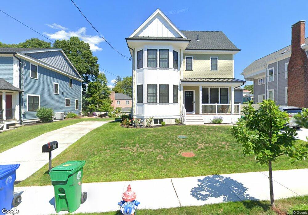
42 Parsons St West Newton, MA 02465
West Newton NeighborhoodEstimated Value: $1,525,000 - $2,852,643
5
Beds
1
Bath
2,512
Sq Ft
$843/Sq Ft
Est. Value
About This Home
This home is located at 42 Parsons St, West Newton, MA 02465 and is currently estimated at $2,116,911, approximately $842 per square foot. 42 Parsons St is a home located in Middlesex County with nearby schools including Horace Mann Elementary School, F.A. Day Middle School, and Newton North High School.
Ownership History
Date
Name
Owned For
Owner Type
Purchase Details
Closed on
Oct 20, 2017
Sold by
Corrigan Agnes L and Carrigan John R
Bought by
Dermovesian Arto and Dermovesian Victoria
Current Estimated Value
Home Financials for this Owner
Home Financials are based on the most recent Mortgage that was taken out on this home.
Original Mortgage
$598,000
Outstanding Balance
$498,962
Interest Rate
3.78%
Mortgage Type
New Conventional
Estimated Equity
$1,617,949
Create a Home Valuation Report for This Property
The Home Valuation Report is an in-depth analysis detailing your home's value as well as a comparison with similar homes in the area
Home Values in the Area
Average Home Value in this Area
Purchase History
| Date | Buyer | Sale Price | Title Company |
|---|---|---|---|
| Dermovesian Arto | $771,000 | -- |
Source: Public Records
Mortgage History
| Date | Status | Borrower | Loan Amount |
|---|---|---|---|
| Open | Dermovesian Arto | $598,000 |
Source: Public Records
Tax History Compared to Growth
Tax History
| Year | Tax Paid | Tax Assessment Tax Assessment Total Assessment is a certain percentage of the fair market value that is determined by local assessors to be the total taxable value of land and additions on the property. | Land | Improvement |
|---|---|---|---|---|
| 2025 | $23,421 | $2,389,900 | $758,900 | $1,631,000 |
| 2024 | $22,646 | $2,320,300 | $736,800 | $1,583,500 |
| 2023 | $22,047 | $2,165,700 | $593,500 | $1,572,200 |
| 2022 | $21,096 | $2,005,300 | $549,500 | $1,455,800 |
| 2021 | $7,685 | $714,200 | $520,800 | $193,400 |
| 2020 | $7,456 | $714,200 | $520,800 | $193,400 |
| 2019 | $7,246 | $693,400 | $505,600 | $187,800 |
| 2018 | $6,755 | $624,300 | $458,900 | $165,400 |
| 2017 | $6,550 | $589,000 | $432,900 | $156,100 |
| 2016 | $6,265 | $550,500 | $404,600 | $145,900 |
| 2015 | $5,973 | $514,500 | $378,100 | $136,400 |
Source: Public Records
Map
Nearby Homes
- 4 Wiswall St
- 12 Wiswall St
- 123 Mount Vernon St Unit 2
- 27 Cross St Unit 27
- 43 Walker St
- 935 Washington St (Rear Facing) Unit 11
- 935 Washington St Unit 8
- 318 Austin St Unit A
- 4 Hosmer Cir
- 911 Washington St
- 321 Albemarle Rd
- 32-34 Rossmere St
- 611 Watertown St Unit 14
- 79 Chestnut St Unit 2
- 354 Linwood Ave Unit 1
- 22 Walnut Place Unit 1
- 168 Walnut St
- 57 Walnut St
- 12 Inis Cir
- 53-55 N Gate Park
- 42 Parsons St Unit 1
- 38 Parsons St
- 36 Parsons St
- 36 Parsons St
- 36 Parsons St Unit 36
- 36 Parsons St
- 36 Parsons St Unit 1
- 46 Parsons St
- 46 Parsons St Unit 46
- 46 Parsons St Unit 2
- 41 Eddy St
- 41 Eddy St Unit 41
- 41 Eddy St
- 50 Parsons St
- 50 Parsons St
- 50 Parsons St Unit 1
- 50 Parsons St Unit 2
- 33 Eddy St Unit 35
- 39 Eddy St
- 39 Eddy St