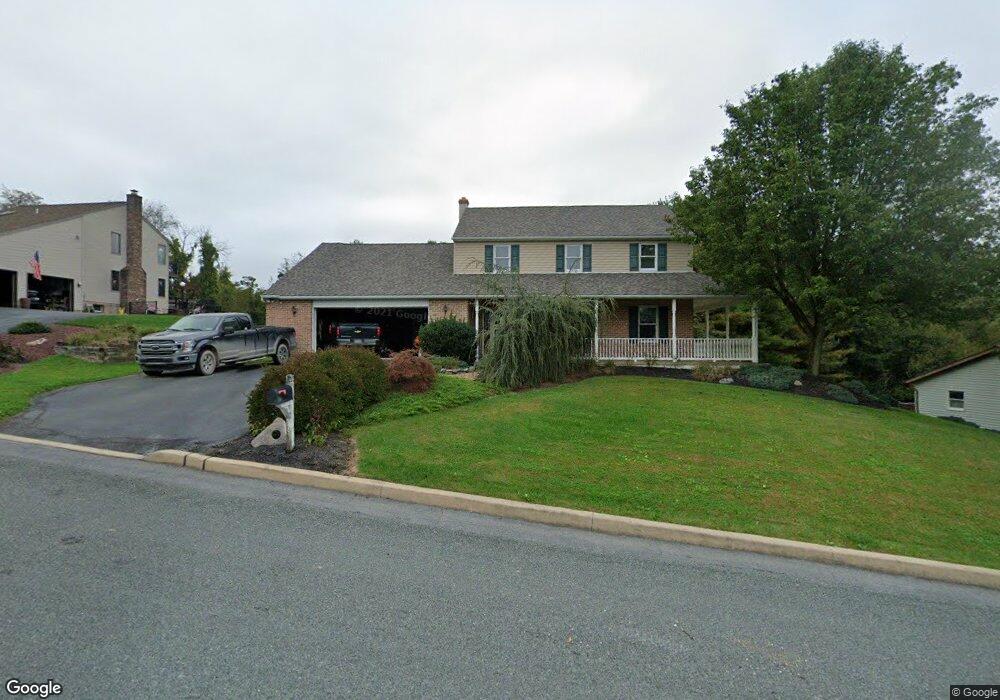
42 Pheasant Run Rd Boyertown, PA 19512
Colebrookdale Township NeighborhoodEstimated Value: $282,000 - $517,000
3
Beds
2
Baths
2,196
Sq Ft
$188/Sq Ft
Est. Value
About This Home
This home is located at 42 Pheasant Run Rd, Boyertown, PA 19512 and is currently estimated at $412,182, approximately $187 per square foot. 42 Pheasant Run Rd is a home located in Berks County with nearby schools including Boyertown Area Senior High School and Brookeside Montessori School.
Ownership History
Date
Name
Owned For
Owner Type
Purchase Details
Closed on
Feb 24, 2003
Sold by
Weidner Keith A and Weidner Sandra L
Bought by
Weidner Keith A
Current Estimated Value
Home Financials for this Owner
Home Financials are based on the most recent Mortgage that was taken out on this home.
Original Mortgage
$100,000
Interest Rate
5.29%
Create a Home Valuation Report for This Property
The Home Valuation Report is an in-depth analysis detailing your home's value as well as a comparison with similar homes in the area
Home Values in the Area
Average Home Value in this Area
Purchase History
| Date | Buyer | Sale Price | Title Company |
|---|---|---|---|
| Weidner Keith A | -- | -- |
Source: Public Records
Mortgage History
| Date | Status | Borrower | Loan Amount |
|---|---|---|---|
| Closed | Weidner Keith A | $100,000 |
Source: Public Records
Tax History Compared to Growth
Tax History
| Year | Tax Paid | Tax Assessment Tax Assessment Total Assessment is a certain percentage of the fair market value that is determined by local assessors to be the total taxable value of land and additions on the property. | Land | Improvement |
|---|---|---|---|---|
| 2025 | $2,461 | $169,200 | $54,600 | $114,600 |
| 2024 | $5,159 | $169,200 | $54,600 | $114,600 |
| 2023 | $7,204 | $169,200 | $54,600 | $114,600 |
| 2022 | $6,887 | $169,200 | $54,600 | $114,600 |
| 2021 | $6,744 | $169,200 | $54,600 | $114,600 |
| 2020 | $6,597 | $169,200 | $54,600 | $114,600 |
| 2019 | $6,434 | $169,200 | $54,600 | $114,600 |
| 2018 | $6,206 | $169,200 | $54,600 | $114,600 |
| 2017 | $5,946 | $169,200 | $54,600 | $114,600 |
| 2016 | $1,854 | $169,200 | $54,600 | $114,600 |
| 2015 | $1,854 | $169,200 | $54,600 | $114,600 |
| 2014 | $1,854 | $169,200 | $54,600 | $114,600 |
Source: Public Records
Map
Nearby Homes
- 332 S Reading Ave
- 100 College St
- 151 S Reading Ave
- 24 Alans Ln
- 0 W Philadelphia Ave
- 119 Schaeffer St
- 1008 Reading Ave
- 0 Rte 73 Unit PABK2041020
- 280 Indian Ln
- 1041 Reading Ave
- 231 N Franklin St
- 201 Henry Ave
- 622 Rhoads Ave
- 141 Greshville Rd
- 626 N Reading Ave
- 1028 Weisstown Rd
- 241 Sweinhart Rd
- 11 Linden Ct Unit 11
- 190 Red Oak Dr
- Norris Plan at Spring Garden Meadows
- 32 Pheasant Run Rd
- 54 Pheasant Run Rd
- 47 Pheasant Run Rd
- 59 Pheasant Run Rd
- 18 Pheasant Run Rd
- 37 Pheasant Run Rd
- 151 S Ironstone Dr
- 64 Pheasant Run Rd
- 25 Pheasant Run Rd
- 71 Pheasant Run Rd
- 143 S Ironstone Dr
- 6 Pheasant Run Rd
- 76 Pheasant Run Rd
- 149 S Ironstone Dr
- 5 Pheasant Run Rd
- 83 Pheasant Run Rd
- 105 S Ironstone Dr
- 105 S Ironstone Dr Unit 2ND FLOOR
- 167 S Ironstone Dr
- 121 S Ironstone Dr