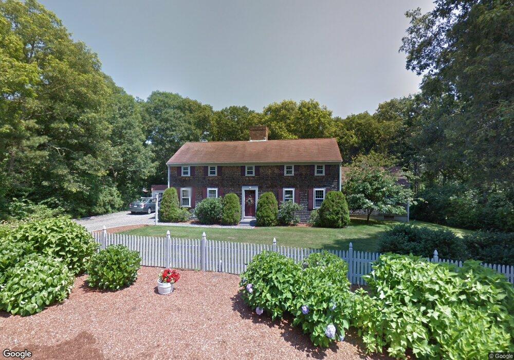
420 Captain Lijahs Rd Barnstable, MA 02632
Centerville NeighborhoodEstimated Value: $707,000 - $933,000
3
Beds
3
Baths
2,490
Sq Ft
$327/Sq Ft
Est. Value
About This Home
This home is located at 420 Captain Lijahs Rd, Barnstable, MA 02632 and is currently estimated at $813,341, approximately $326 per square foot. 420 Captain Lijahs Rd is a home located in Barnstable County with nearby schools including Centerville Elementary School, Barnstable United Elementary School, and Barnstable Intermediate School.
Ownership History
Date
Name
Owned For
Owner Type
Purchase Details
Closed on
Jul 8, 2024
Sold by
Anderson Richard W and Anderson Erin N
Bought by
Anderson Ft and Anderson
Current Estimated Value
Purchase Details
Closed on
Mar 18, 2016
Sold by
Fougere Robert F and Fougere Barbara M
Bought by
Anderson Richard W and Anderson Erin N
Home Financials for this Owner
Home Financials are based on the most recent Mortgage that was taken out on this home.
Original Mortgage
$296,000
Interest Rate
3.72%
Mortgage Type
New Conventional
Purchase Details
Closed on
Jan 15, 1997
Sold by
Landers Richard E and Landers Margaret R
Bought by
Fougere Robert F and Fougere Barbara M
Create a Home Valuation Report for This Property
The Home Valuation Report is an in-depth analysis detailing your home's value as well as a comparison with similar homes in the area
Home Values in the Area
Average Home Value in this Area
Purchase History
| Date | Buyer | Sale Price | Title Company |
|---|---|---|---|
| Anderson Ft | -- | None Available | |
| Anderson Ft | -- | None Available | |
| Anderson Richard W | $370,000 | -- | |
| Fougere Robert F | $159,000 | -- | |
| Fougere Robert F | $159,000 | -- |
Source: Public Records
Mortgage History
| Date | Status | Borrower | Loan Amount |
|---|---|---|---|
| Previous Owner | Anderson Richard W | $296,000 | |
| Previous Owner | Fougere Robert F | $295,025 |
Source: Public Records
Tax History Compared to Growth
Tax History
| Year | Tax Paid | Tax Assessment Tax Assessment Total Assessment is a certain percentage of the fair market value that is determined by local assessors to be the total taxable value of land and additions on the property. | Land | Improvement |
|---|---|---|---|---|
| 2025 | $6,606 | $816,600 | $154,500 | $662,100 |
| 2024 | $5,739 | $734,800 | $154,500 | $580,300 |
| 2023 | $6,070 | $727,800 | $140,500 | $587,300 |
| 2022 | $5,788 | $600,400 | $104,100 | $496,300 |
| 2021 | $2,082 | $540,300 | $104,100 | $436,200 |
| 2020 | $2,013 | $478,900 | $104,100 | $374,800 |
| 2019 | $1,918 | $450,100 | $104,100 | $346,000 |
| 2018 | $3,930 | $350,300 | $109,500 | $240,800 |
| 2017 | $3,699 | $343,800 | $109,500 | $234,300 |
| 2016 | $3,758 | $344,800 | $110,500 | $234,300 |
| 2015 | $3,718 | $342,700 | $107,700 | $235,000 |
Source: Public Records
Map
Nearby Homes
- 62 3 Ponds Dr
- 62 Three Ponds Dr
- 66 Tern Ln
- 73 Tern Ln
- 900 Old Stage Rd
- 2181 Service Rd
- 40 Appaloosa Way
- 39 Lakewood Dr
- 29 Summerwind Ln
- 350 Plum St
- 350 & 360 Plum St
- 88 Joe Thompson Rd
- 74 Saddler Ln
- 80 Saddler Ln
- 296 Buckskin Path
- 50 Currycomb Cir
- 9 Locust Ave
- 1825 Main St
- 1044 Old Falmouth Rd
- 282 Parker Rd
- 420 Capn Lijahs Rd
- 11 Helmsman Dr
- 390 Capn Lijah Rd
- 438 Capn Lijahs Rd
- 438 Cap'N Lijah's Rd
- 429 Capn Lijahs Rd
- 112 Capn Jacs Rd
- 25 Helmsman Dr
- 8 Vista Cir
- 8 Vista Cir
- 395 Capn Lijahs Rd
- 3 Halyard Way
- 102 Capn Jacs Rd
- 9 Halyard Way
- 1 Halyard Way
- 372 Capn Lijahs Rd
- 103 Captain Jacs Rd
- 26 Helmsman Dr
- 454 Capn Lijahs Rd
- 19 Halyard Way