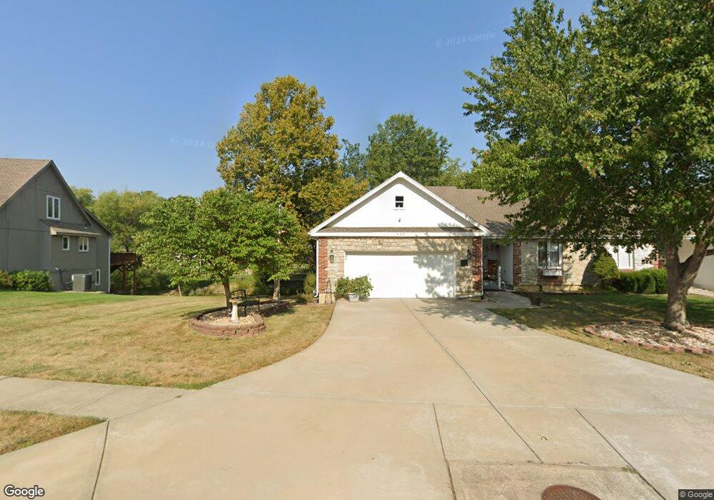
420 NW Timberbrooke Dr Lees Summit, MO 64081
Estimated Value: $364,744 - $378,000
2
Beds
3
Baths
1,553
Sq Ft
$238/Sq Ft
Est. Value
About This Home
This home is located at 420 NW Timberbrooke Dr, Lees Summit, MO 64081 and is currently estimated at $369,936, approximately $238 per square foot. 420 NW Timberbrooke Dr is a home located in Jackson County with nearby schools including Cedar Creek Elementary School, Pleasant Lea Middle School, and Lee's Summit Senior High School.
Ownership History
Date
Name
Owned For
Owner Type
Purchase Details
Closed on
May 28, 2015
Sold by
Farmer Anastasia R and Mills Melissa Ann
Bought by
Mills John Joseph and Mills Melissa Ann
Current Estimated Value
Purchase Details
Closed on
Oct 20, 2000
Sold by
Farmer Anastasia R
Bought by
Farmer Anastasia R and Anastasia R Farmer Living Trust
Purchase Details
Closed on
Sep 7, 2000
Sold by
Farmer Anastasia R
Bought by
Collier Susan Lee and Mills Melissa Ann
Create a Home Valuation Report for This Property
The Home Valuation Report is an in-depth analysis detailing your home's value as well as a comparison with similar homes in the area
Home Values in the Area
Average Home Value in this Area
Purchase History
| Date | Buyer | Sale Price | Title Company |
|---|---|---|---|
| Mills John Joseph | -- | None Available | |
| Farmer Anastasia R | -- | -- | |
| Collier Susan Lee | -- | -- |
Source: Public Records
Tax History
| Year | Tax Paid | Tax Assessment Tax Assessment Total Assessment is a certain percentage of the fair market value that is determined by local assessors to be the total taxable value of land and additions on the property. | Land | Improvement |
|---|---|---|---|---|
| 2025 | $3,608 | $54,777 | $16,313 | $38,464 |
| 2024 | $3,608 | $49,970 | $9,644 | $40,326 |
| 2023 | $3,582 | $49,970 | $9,644 | $40,326 |
| 2022 | $3,344 | $41,420 | $6,280 | $35,140 |
| 2021 | $3,413 | $41,420 | $6,280 | $35,140 |
| 2020 | $3,019 | $36,286 | $6,280 | $30,006 |
| 2019 | $2,937 | $36,286 | $6,280 | $30,006 |
| 2018 | $2,670 | $30,616 | $2,985 | $27,631 |
| 2017 | $2,630 | $30,616 | $2,985 | $27,631 |
| 2016 | $2,630 | $29,849 | $2,983 | $26,866 |
| 2014 | $2,522 | $28,058 | $2,793 | $25,265 |
Source: Public Records
Map
Nearby Homes
- 507 NW Ashurst Ct
- 334 NW Ambersham Dr
- 2430 NW Windwood Dr
- 209 NW Cody Dr
- 2214 NW Killarney Ln
- 2635 NW Ashurst Ln
- 2122 NW Ashurst Dr
- 2086 NW O'Brien Rd
- 433 NW Kaylea Ct
- 2074 NW O'Brien Rd
- 2110 NW Ashurst Dr
- 2070 NW O'Brien Rd
- 2224 NW Summerfield Dr
- 2127 NW Killarney Ln
- 2123 NW Killarney Ln
- 129 NW Morton Dr
- 955 NW High Point Dr
- 321 NW Nutall Dr
- 2809 NW Audubon Ln
- 2114 NW Killarney Ln
- 418 NW Timberbrooke Dr
- 422 NW Timberbrooke Dr
- 2401 NW Ashurst Dr
- 416 NW Timberbrooke Dr
- 423 NW Timberbrooke Dr
- 421 NW Timberbrooke Dr
- 414 NW Timberbrooke Dr
- 504 NW Timberbrooke Dr
- 419 NW Timberbrooke Dr
- 503 NW Alexa Ln
- 417 NW Ashurst Cir
- 2407 NW Ashurst Dr
- 417 NW Timberbrooke Dr
- 506 NW Timberbrooke Dr
- 412 NW Timberbrooke Dr
- 428 NW Whitlock Dr
- 2400 NW Ashurst Dr
- 2332 NW Ashurst Dr
- 424 NW Whitlock Dr
- 505 NW Alexa Ln
Your Personal Tour Guide
Ask me questions while you tour the home.