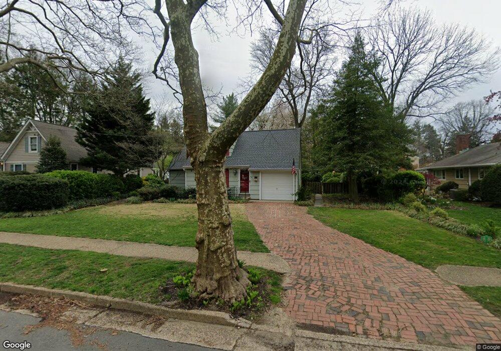
420 W 3rd St Moorestown, NJ 08057
Estimated Value: $464,000 - $549,000
3
Beds
2
Baths
1,479
Sq Ft
$344/Sq Ft
Est. Value
About This Home
This home is located at 420 W 3rd St, Moorestown, NJ 08057 and is currently estimated at $508,681, approximately $343 per square foot. 420 W 3rd St is a home located in Burlington County with nearby schools including George C. Baker Elementary School, Moorestown Upper Elementary School, and William Allen Middle School.
Ownership History
Date
Name
Owned For
Owner Type
Purchase Details
Closed on
Nov 25, 2002
Sold by
Vanartsdalen David J and Vanartsdalen Maureen L
Bought by
Alber Lisette K
Current Estimated Value
Home Financials for this Owner
Home Financials are based on the most recent Mortgage that was taken out on this home.
Original Mortgage
$200,000
Outstanding Balance
$85,477
Interest Rate
6.17%
Estimated Equity
$423,204
Purchase Details
Closed on
Feb 24, 1998
Sold by
Ryan Maureen L and Vanartsdalen Maureen L
Bought by
Vanartsdalen David J and Artsdalen Maureen L
Home Financials for this Owner
Home Financials are based on the most recent Mortgage that was taken out on this home.
Original Mortgage
$112,500
Interest Rate
6.93%
Create a Home Valuation Report for This Property
The Home Valuation Report is an in-depth analysis detailing your home's value as well as a comparison with similar homes in the area
Home Values in the Area
Average Home Value in this Area
Purchase History
| Date | Buyer | Sale Price | Title Company |
|---|---|---|---|
| Alber Lisette K | $250,000 | Congress Title | |
| Vanartsdalen David J | -- | The Title Group Agency Inc |
Source: Public Records
Mortgage History
| Date | Status | Borrower | Loan Amount |
|---|---|---|---|
| Open | Alber Lisette K | $200,000 | |
| Previous Owner | Vanartsdalen David J | $112,500 |
Source: Public Records
Tax History Compared to Growth
Tax History
| Year | Tax Paid | Tax Assessment Tax Assessment Total Assessment is a certain percentage of the fair market value that is determined by local assessors to be the total taxable value of land and additions on the property. | Land | Improvement |
|---|---|---|---|---|
| 2025 | $6,710 | $236,500 | $123,300 | $113,200 |
| 2024 | $6,506 | $236,500 | $123,300 | $113,200 |
| 2023 | $6,506 | $236,500 | $123,300 | $113,200 |
| 2022 | $6,440 | $236,500 | $123,300 | $113,200 |
| 2021 | $5,444 | $236,500 | $123,300 | $113,200 |
| 2020 | $6,315 | $236,500 | $123,300 | $113,200 |
| 2019 | $6,203 | $236,500 | $123,300 | $113,200 |
| 2018 | $6,035 | $236,500 | $123,300 | $113,200 |
| 2017 | $6,088 | $236,500 | $123,300 | $113,200 |
| 2016 | $6,066 | $236,500 | $123,300 | $113,200 |
| 2015 | $5,993 | $236,500 | $123,300 | $113,200 |
| 2014 | $5,690 | $236,500 | $123,300 | $113,200 |
Source: Public Records
Map
Nearby Homes
- 313 Fairview Ave
- 316 W 3rd St
- 531 Covington Terrace
- 423 Park Blvd
- 601 Stratford Dr
- 600 Stratford Dr
- 316 Farmdale Rd
- 308 Farmdale Rd
- 493 N Church St
- 4 W Close
- 543 Bethel Ave
- 129 S Church St
- 709 Manor Terrace
- 308 Kenwood Dr
- 801 E Camden Ave
- 310 S Washington Ave
- 15 E 2nd St
- 206 E Camden Ave
- 149 Chalkboard Ct
- 50 E 3rd St