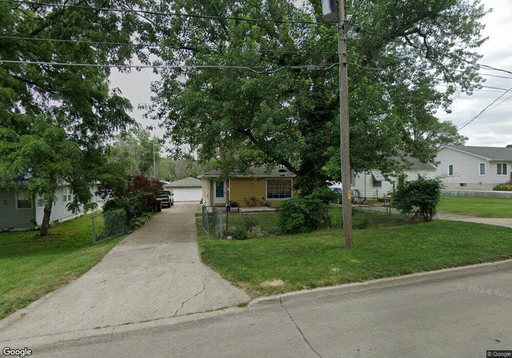
4203 SW 12th St Des Moines, IA 50315
Watrous South NeighborhoodEstimated Value: $174,321 - $211,000
3
Beds
1
Bath
931
Sq Ft
$206/Sq Ft
Est. Value
About This Home
This home is located at 4203 SW 12th St, Des Moines, IA 50315 and is currently estimated at $192,080, approximately $206 per square foot. 4203 SW 12th St is a home located in Polk County with nearby schools including Park Avenue Elementary School, Brody Middle School, and Lincoln High School.
Ownership History
Date
Name
Owned For
Owner Type
Purchase Details
Closed on
Apr 8, 2002
Sold by
Hari Ohm Inc
Bought by
Bails Matthew J
Current Estimated Value
Home Financials for this Owner
Home Financials are based on the most recent Mortgage that was taken out on this home.
Original Mortgage
$89,017
Outstanding Balance
$36,556
Interest Rate
6.82%
Mortgage Type
FHA
Estimated Equity
$155,524
Purchase Details
Closed on
Oct 13, 1997
Sold by
Gates James Daniel and Gates Josephine Phillis
Bought by
Hari Ohm Inc
Create a Home Valuation Report for This Property
The Home Valuation Report is an in-depth analysis detailing your home's value as well as a comparison with similar homes in the area
Home Values in the Area
Average Home Value in this Area
Purchase History
| Date | Buyer | Sale Price | Title Company |
|---|---|---|---|
| Bails Matthew J | $90,000 | -- | |
| Hari Ohm Inc | $67,500 | -- |
Source: Public Records
Mortgage History
| Date | Status | Borrower | Loan Amount |
|---|---|---|---|
| Open | Bails Matthew J | $89,017 |
Source: Public Records
Tax History Compared to Growth
Tax History
| Year | Tax Paid | Tax Assessment Tax Assessment Total Assessment is a certain percentage of the fair market value that is determined by local assessors to be the total taxable value of land and additions on the property. | Land | Improvement |
|---|---|---|---|---|
| 2025 | $2,996 | $170,000 | $28,300 | $141,700 |
| 2024 | $2,996 | $152,300 | $25,000 | $127,300 |
| 2023 | $2,948 | $152,300 | $25,000 | $127,300 |
| 2022 | $2,926 | $125,100 | $21,200 | $103,900 |
| 2021 | $2,932 | $125,100 | $21,200 | $103,900 |
| 2020 | $3,046 | $117,500 | $19,900 | $97,600 |
| 2019 | $2,828 | $117,500 | $19,900 | $97,600 |
| 2018 | $2,798 | $105,200 | $17,400 | $87,800 |
| 2017 | $2,600 | $105,200 | $17,400 | $87,800 |
| 2016 | $2,532 | $96,100 | $15,600 | $80,500 |
| 2015 | $2,532 | $96,100 | $15,600 | $80,500 |
| 2014 | $2,580 | $97,100 | $15,400 | $81,700 |
Source: Public Records
Map
Nearby Homes
- 4108 SW 12th St
- 4020 SW 12th St
- 1204 Elder Ln
- 1219 Elder Ln
- 1222 Watrous Ave
- 1207 Emma Ave
- 1223 Emma Ave
- 3808 SW 12th St
- 1109 Herold Ave
- 930 Emma Ave
- 1203 Herold Ave
- 3724 SW 13th St
- 1116 Herold Ave
- 3903 SW 9th St
- 4204 SW 7th St
- . Herold Ave
- 606 Marion St
- 3618 SW 9th St
- 3514 SW 12th St
- 1607 Carrie Ave
- 4205 SW 12th St
- 4201 SW 12th St
- 1118 Carrie Ave
- 4211 SW 12th St
- 1109 Elder Ln
- 4219 SW 12th St
- 1112 Carrie Ave
- 1114 Carrie Ave
- 1123 Carrie Ave
- 1203 Carrie Ave
- 1117 Carrie Ave
- 1105 Elder Ln
- 4216 SW 12th St
- 4107 SW 12th St
- 1107 Carrie Ave
- 1100 Carrie Ave
- 1101 Elder Ln
- 4220 SW 12th St
- 1209 Carrie Ave
- 1015 Elder Ln