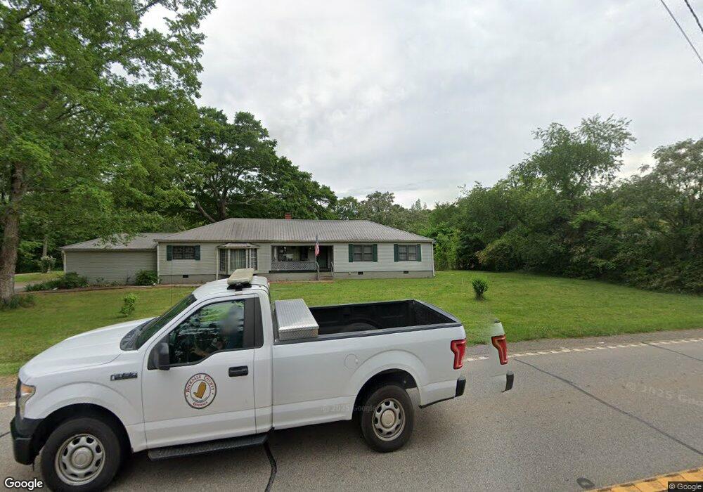
4207 Highway 212 Covington, GA 30016
Estimated Value: $321,022 - $359,000
Studio
2
Baths
2,484
Sq Ft
$139/Sq Ft
Est. Value
About This Home
This home is located at 4207 Highway 212, Covington, GA 30016 and is currently estimated at $345,506, approximately $139 per square foot. 4207 Highway 212 is a home located in Newton County with nearby schools including Oak Hill Elementary School, Veterans Memorial Middle School, and Alcovy High School.
Ownership History
Date
Name
Owned For
Owner Type
Purchase Details
Closed on
Mar 23, 2004
Sold by
Amerson Ray A
Bought by
Amerson Ray A and Amerson Norma
Current Estimated Value
Home Financials for this Owner
Home Financials are based on the most recent Mortgage that was taken out on this home.
Original Mortgage
$66,000
Outstanding Balance
$30,265
Interest Rate
5.62%
Mortgage Type
New Conventional
Estimated Equity
$315,241
Purchase Details
Closed on
Feb 20, 2004
Sold by
Ammerson Grady C
Bought by
Amerson Riay A
Home Financials for this Owner
Home Financials are based on the most recent Mortgage that was taken out on this home.
Original Mortgage
$66,000
Outstanding Balance
$30,265
Interest Rate
5.62%
Mortgage Type
New Conventional
Estimated Equity
$315,241
Purchase Details
Closed on
Nov 1, 2003
Sold by
Amerson Frances G
Bought by
Amerson Ray A and Amerson Grady
Create a Home Valuation Report for This Property
The Home Valuation Report is an in-depth analysis detailing your home's value as well as a comparison with similar homes in the area
Home Values in the Area
Average Home Value in this Area
Purchase History
| Date | Buyer | Sale Price | Title Company |
|---|---|---|---|
| Amerson Ray A | -- | -- | |
| Amerson Riay A | -- | -- | |
| Amerson Ray A | -- | -- |
Source: Public Records
Mortgage History
| Date | Status | Borrower | Loan Amount |
|---|---|---|---|
| Open | Amerson Ray A | $66,000 |
Source: Public Records
Tax History
| Year | Tax Paid | Tax Assessment Tax Assessment Total Assessment is a certain percentage of the fair market value that is determined by local assessors to be the total taxable value of land and additions on the property. | Land | Improvement |
|---|---|---|---|---|
| 2025 | $2,452 | $140,760 | $26,880 | $113,880 |
| 2024 | $2,185 | $127,840 | $17,760 | $110,080 |
| 2023 | $1,508 | $84,600 | $16,417 | $68,183 |
| 2022 | $1,508 | $84,600 | $16,417 | $68,183 |
| 2021 | $1,683 | $84,600 | $17,760 | $66,840 |
| 2020 | $1,231 | $65,840 | $12,600 | $53,240 |
| 2019 | $1,248 | $65,800 | $12,600 | $53,200 |
| 2018 | $1,272 | $66,280 | $12,600 | $53,680 |
| 2017 | $832 | $53,440 | $9,440 | $44,000 |
| 2016 | $689 | $49,280 | $9,440 | $39,840 |
| 2015 | $608 | $47,000 | $9,440 | $37,560 |
| 2014 | $316 | $38,560 | $0 | $0 |
Source: Public Records
Map
Nearby Homes
- 5506 Highway 81 S
- 143 Covered Bridge Rd
- 161 Covered Bridge Rd
- 1062 Crown Landing Pkwy
- 4627 Highway 212
- 1087 Crown Landing Pkwy
- 444 Covered Bridge Rd
- 6192 Highway 81 E
- 90 Harvey Ave
- 127 Covered Bridge Rd
- 119 Covered Bridge Rd
- 153 Helen Rd
- 15 Granville Ln
- 137 Jackson Lake Rd
- 230 Barcelona Dr
- 25 Shadowbrook Ct
- 50 Cranbrook Ct
- 190 Shadowbrook Trace
- 200 Shadowbrook Trace
- 768 Wehunt Rd
- 4215 Highway 212
- 4227 Highway 212
- 4227 Highway 212
- 4206 Highway 212
- 4241 Highway 212
- 4241 Highway 212
- 4237 Highway 212
- 4227 Georgia 212
- 4271 Georgia 212
- 5672 Highway 81 S
- 4271 Highway 212
- 4134 Highway 212
- 4134 Highway 212
- 4248 Highway 212
- 4303 Highway 212
- 5666 Highway 81 S
- 4310 Georgia 212
- 195 Snapping Shoals
- 48 Covered Bridge Rd
Your Personal Tour Guide
Ask me questions while you tour the home.