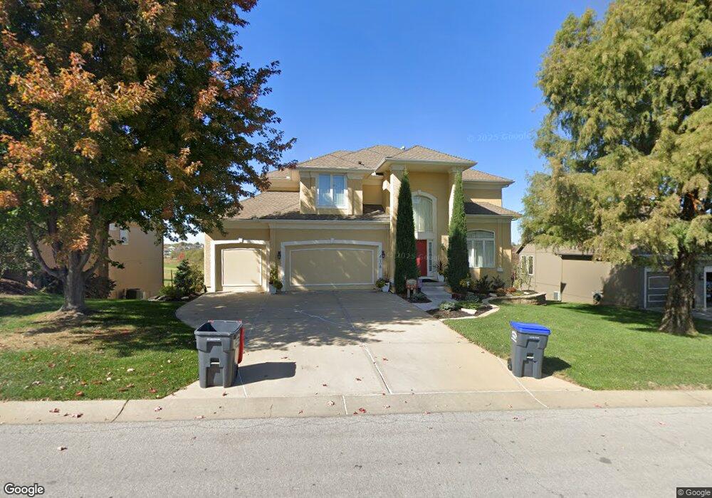
4208 N 141st St Basehor, KS 66007
Estimated Value: $707,366 - $741,000
5
Beds
5
Baths
3,556
Sq Ft
$203/Sq Ft
Est. Value
About This Home
This home is located at 4208 N 141st St, Basehor, KS 66007 and is currently estimated at $723,092, approximately $203 per square foot. 4208 N 141st St is a home located in Leavenworth County with nearby schools including Basehor Elementary School, Basehor-Linwood Middle School, and Basehor-Linwood High School.
Ownership History
Date
Name
Owned For
Owner Type
Purchase Details
Closed on
Jan 1, 2005
Bought by
Howell Scott P and Scott Mary R
Current Estimated Value
Home Financials for this Owner
Home Financials are based on the most recent Mortgage that was taken out on this home.
Original Mortgage
$169,000
Outstanding Balance
$121,469
Interest Rate
5.81%
Mortgage Type
New Conventional
Estimated Equity
$601,623
Create a Home Valuation Report for This Property
The Home Valuation Report is an in-depth analysis detailing your home's value as well as a comparison with similar homes in the area
Home Values in the Area
Average Home Value in this Area
Purchase History
| Date | Buyer | Sale Price | Title Company |
|---|---|---|---|
| Howell Scott P | $393,618 | -- |
Source: Public Records
Mortgage History
| Date | Status | Borrower | Loan Amount |
|---|---|---|---|
| Open | Howell Scott P | $169,000 | |
| Closed | Howell Scott P | $198,000 |
Source: Public Records
Tax History Compared to Growth
Tax History
| Year | Tax Paid | Tax Assessment Tax Assessment Total Assessment is a certain percentage of the fair market value that is determined by local assessors to be the total taxable value of land and additions on the property. | Land | Improvement |
|---|---|---|---|---|
| 2025 | $10,945 | $78,525 | $15,152 | $63,373 |
| 2024 | $10,125 | $76,238 | $15,152 | $61,086 |
| 2023 | $10,125 | $73,591 | $11,286 | $62,305 |
| 2022 | $9,554 | $66,297 | $10,520 | $55,777 |
| 2021 | $8,471 | $58,995 | $8,766 | $50,229 |
| 2020 | $8,111 | $55,533 | $8,766 | $46,767 |
| 2019 | $8,021 | $55,533 | $5,843 | $49,690 |
| 2018 | $7,840 | $51,083 | $5,843 | $45,240 |
| 2017 | $7,310 | $47,207 | $5,843 | $41,364 |
| 2016 | $7,131 | $46,195 | $5,843 | $40,352 |
| 2015 | $6,507 | $43,336 | $5,843 | $37,493 |
| 2014 | $6,072 | $40,653 | $4,975 | $35,678 |
Source: Public Records
Map
Nearby Homes
- 4310 N 141st Place
- 4417 N 141st St
- 4418 Tee Box Dr
- 4151 Lake Shore Dr
- 4250 Aspen Dr
- 4145 Lake Shore Dr
- 4270 Lake Shore Dr
- 4248 Lake Shore Dr
- 4271 Aspen Dr
- The Azalea I Plan at The Communities of Falcon Lakes - Falcon Lakes
- 14574 Aurora Ln
- 4282 Lake Shore Dr
- 4343-4501 N 139th St
- 4377 Tee Box Dr
- Yorkshire V Plan at The Communities of Falcon Lakes - The Communities at Falcon Lakes
- Ashwood Plan at The Communities of Falcon Lakes - The Communities at Falcon Lakes
- Cypress II Plan at The Communities of Falcon Lakes - The Communities at Falcon Lakes
- The York Plan at The Communities of Falcon Lakes - The Communties of Falcon Lakes
- The Wyndham V Plan at The Communities of Falcon Lakes - The Communties of Falcon Lakes
- The Wyndham II Plan at The Communities of Falcon Lakes - The Communties of Falcon Lakes
- 4204 N 141st St
- 4210 N 141st St
- 4200 N 141st St
- 4209 N 141st St
- 4205 N 141st St
- 4213 N 141st St
- 14163 Belrive Cir
- 4201 N 141st St
- 4217 N 141st St
- 4119 N 141st St
- 14159 Belrive Cir
- 4116 N 141st St
- 4300 N 141st St
- 4221 N 141st St
- 4117 N 141st St
- 0 141st St Unit 2130191
- 0 141st St Unit 1518158
- Lot 25 141st St
- Lot 22 141st St
- Lot 21 141st St