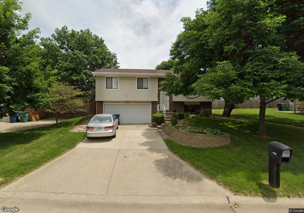
4209 91st St Urbandale, IA 50322
Estimated Value: $267,452 - $281,000
3
Beds
1
Bath
954
Sq Ft
$289/Sq Ft
Est. Value
About This Home
This home is located at 4209 91st St, Urbandale, IA 50322 and is currently estimated at $275,613, approximately $288 per square foot. 4209 91st St is a home located in Polk County with nearby schools including Urbandale Middle School, Urbandale High School, and St Pius X School.
Ownership History
Date
Name
Owned For
Owner Type
Purchase Details
Closed on
Jul 23, 2002
Sold by
Shepherd Jeffrey R and Shepherd Michelle A
Bought by
Byrnes Shelley K
Current Estimated Value
Home Financials for this Owner
Home Financials are based on the most recent Mortgage that was taken out on this home.
Original Mortgage
$111,636
Outstanding Balance
$47,627
Interest Rate
6.8%
Estimated Equity
$227,986
Purchase Details
Closed on
Apr 28, 1998
Sold by
Schramm Brian T and Schramm Kathleen Sue
Bought by
Shepherd Jeffrey R and Shepherd Michelle A
Home Financials for this Owner
Home Financials are based on the most recent Mortgage that was taken out on this home.
Original Mortgage
$97,850
Interest Rate
7.18%
Create a Home Valuation Report for This Property
The Home Valuation Report is an in-depth analysis detailing your home's value as well as a comparison with similar homes in the area
Home Values in the Area
Average Home Value in this Area
Purchase History
| Date | Buyer | Sale Price | Title Company |
|---|---|---|---|
| Byrnes Shelley K | $132,500 | -- | |
| Shepherd Jeffrey R | $102,500 | -- |
Source: Public Records
Mortgage History
| Date | Status | Borrower | Loan Amount |
|---|---|---|---|
| Open | Byrnes Shelley K | $111,636 | |
| Previous Owner | Shepherd Jeffrey R | $97,850 |
Source: Public Records
Tax History Compared to Growth
Tax History
| Year | Tax Paid | Tax Assessment Tax Assessment Total Assessment is a certain percentage of the fair market value that is determined by local assessors to be the total taxable value of land and additions on the property. | Land | Improvement |
|---|---|---|---|---|
| 2025 | $4,102 | $259,900 | $73,200 | $186,700 |
| 2024 | $4,102 | $236,900 | $65,800 | $171,100 |
| 2023 | $3,920 | $236,900 | $65,800 | $171,100 |
| 2022 | $3,874 | $191,600 | $54,400 | $137,200 |
| 2021 | $3,692 | $191,600 | $54,400 | $137,200 |
| 2020 | $3,624 | $173,800 | $49,400 | $124,400 |
| 2019 | $3,620 | $173,800 | $49,400 | $124,400 |
| 2018 | $3,482 | $165,900 | $46,200 | $119,700 |
| 2017 | $3,186 | $165,900 | $46,200 | $119,700 |
| 2016 | $3,102 | $149,800 | $41,400 | $108,400 |
| 2015 | $3,102 | $149,800 | $41,400 | $108,400 |
| 2014 | $2,820 | $135,800 | $36,900 | $98,900 |
Source: Public Records
Map
Nearby Homes
- 4221 90th St
- 8914 Valdez Dr
- 9107 Tanglewood Dr
- 4460 90th St
- 4473 89th St
- 8626 Alpine Dr Unit D
- 4480 87th St Unit 10
- 8641 Alpine Dr Unit E
- 4529 91st St
- 3957 92nd Dr
- 8220 Twana Dr
- 8505 Airline Ave
- 8501 Airline Ave
- 4117 83rd St
- 3916 Greenview Dr
- 3889 92nd Dr
- 4708 89th St
- 4748 Hillsdale Dr
- Danbury Plan at Oakwood Haven
- Carson Plan at Oakwood Haven