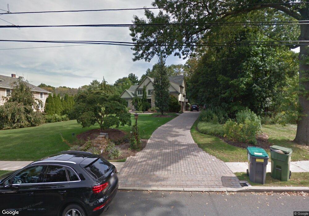
421 North St Doylestown, PA 18901
Estimated Value: $1,492,803 - $1,658,000
3
Beds
4
Baths
4,413
Sq Ft
$359/Sq Ft
Est. Value
About This Home
This home is located at 421 North St, Doylestown, PA 18901 and is currently estimated at $1,582,934, approximately $358 per square foot. 421 North St is a home located in Bucks County with nearby schools including Linden El School, Lenape Middle School, and Central Bucks High School-West.
Ownership History
Date
Name
Owned For
Owner Type
Purchase Details
Closed on
Sep 1, 2021
Sold by
Ciliberto Bernard K
Bought by
Mcguigan Matthew J and Mcguigan Julie Ann
Current Estimated Value
Home Financials for this Owner
Home Financials are based on the most recent Mortgage that was taken out on this home.
Original Mortgage
$775,000
Outstanding Balance
$705,923
Interest Rate
2.87%
Mortgage Type
New Conventional
Estimated Equity
$877,011
Purchase Details
Closed on
Oct 22, 2018
Sold by
Ciliberto Cydney S
Bought by
Ciliberto Bernard K
Purchase Details
Closed on
Oct 3, 2006
Sold by
Ciliberto Cydney S
Bought by
Ciliberto Cydney S
Purchase Details
Closed on
Jul 9, 2004
Sold by
Ciliberto Bernard K and Ciliberto Cydney S
Bought by
Ciliberto Cydney S
Purchase Details
Closed on
May 12, 1994
Sold by
Overholt Margaret L
Bought by
Overholt Darwin and Harris Vernon
Create a Home Valuation Report for This Property
The Home Valuation Report is an in-depth analysis detailing your home's value as well as a comparison with similar homes in the area
Home Values in the Area
Average Home Value in this Area
Purchase History
| Date | Buyer | Sale Price | Title Company |
|---|---|---|---|
| Mcguigan Matthew J | $1,250,000 | Trident Land Transfer Co Lp | |
| Ciliberto Bernard K | -- | Security Abstract Of Pa Inc | |
| Ciliberto Cydney S | -- | None Available | |
| Ciliberto Cydney S | -- | None Available | |
| Ciliberto Cydney S | -- | -- | |
| Overholt Darwin | -- | -- |
Source: Public Records
Mortgage History
| Date | Status | Borrower | Loan Amount |
|---|---|---|---|
| Open | Mcguigan Matthew J | $775,000 |
Source: Public Records
Tax History Compared to Growth
Tax History
| Year | Tax Paid | Tax Assessment Tax Assessment Total Assessment is a certain percentage of the fair market value that is determined by local assessors to be the total taxable value of land and additions on the property. | Land | Improvement |
|---|---|---|---|---|
| 2025 | $14,981 | $83,160 | $10,550 | $72,610 |
| 2024 | $14,981 | $83,160 | $10,550 | $72,610 |
| 2023 | $14,273 | $83,160 | $10,550 | $72,610 |
| 2022 | $14,075 | $83,160 | $10,550 | $72,610 |
| 2021 | $13,920 | $83,160 | $10,550 | $72,610 |
| 2020 | $13,767 | $83,160 | $10,550 | $72,610 |
| 2019 | $13,615 | $83,160 | $10,550 | $72,610 |
| 2018 | $13,449 | $83,160 | $10,550 | $72,610 |
| 2017 | $13,308 | $83,160 | $10,550 | $72,610 |
| 2016 | $13,308 | $83,160 | $10,550 | $72,610 |
| 2015 | -- | $83,160 | $10,550 | $72,610 |
| 2014 | -- | $83,160 | $10,550 | $72,610 |
Source: Public Records
Map
Nearby Homes
- 418 North St
- 90 Chapman Ave
- 121 Cottage St
- 146 N Church St
- 169 N Main St
- 146 E Court St
- 4 Barnes Ct
- 20 E Court St
- 155 E Oakland Ave
- 5 Belmont Square
- 69 E Oakland Ave
- 339 E Ashland St
- 333 Dorset Ct Unit 333
- 37 N Clinton St
- 110 E Ashland St
- 215 N Franklin St
- 104 Kreutz Ave
- 0 Myers Dr
- 143 Myers Dr
- 236 Green St