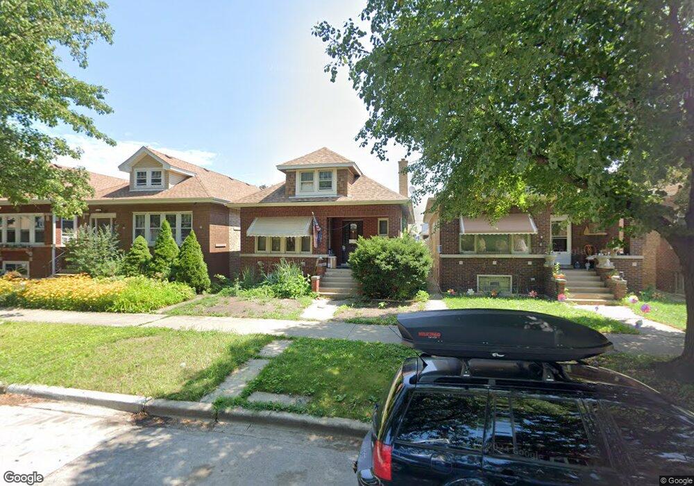
4211 N Monitor Ave Chicago, IL 60634
Portage Park NeighborhoodEstimated Value: $344,000 - $421,619
2
Beds
1
Bath
958
Sq Ft
$394/Sq Ft
Est. Value
About This Home
This home is located at 4211 N Monitor Ave, Chicago, IL 60634 and is currently estimated at $377,655, approximately $394 per square foot. 4211 N Monitor Ave is a home located in Cook County with nearby schools including Smyser Elementary School, Taft High School, and Pope Francis Global Academy.
Ownership History
Date
Name
Owned For
Owner Type
Purchase Details
Closed on
Sep 7, 2006
Sold by
Pahlke Lawrence G
Bought by
Parkway Bank & Trust Co and Trust #14223
Current Estimated Value
Purchase Details
Closed on
Sep 12, 2003
Sold by
Grubbs Frances M
Bought by
Pahlke Lawrence G and Pahlke Larry
Home Financials for this Owner
Home Financials are based on the most recent Mortgage that was taken out on this home.
Original Mortgage
$170,400
Interest Rate
6.23%
Mortgage Type
Unknown
Purchase Details
Closed on
May 19, 1998
Sold by
Grubbs Frances M
Bought by
Grubbs Frances M and Frances M Grubbs Trust
Create a Home Valuation Report for This Property
The Home Valuation Report is an in-depth analysis detailing your home's value as well as a comparison with similar homes in the area
Home Values in the Area
Average Home Value in this Area
Purchase History
| Date | Buyer | Sale Price | Title Company |
|---|---|---|---|
| Parkway Bank & Trust Co | -- | None Available | |
| Pahlke Lawrence G | $213,000 | Pntn | |
| Grubbs Frances M | -- | -- |
Source: Public Records
Mortgage History
| Date | Status | Borrower | Loan Amount |
|---|---|---|---|
| Previous Owner | Pahlke Lawrence G | $170,400 |
Source: Public Records
Tax History Compared to Growth
Tax History
| Year | Tax Paid | Tax Assessment Tax Assessment Total Assessment is a certain percentage of the fair market value that is determined by local assessors to be the total taxable value of land and additions on the property. | Land | Improvement |
|---|---|---|---|---|
| 2024 | $5,918 | $30,848 | $13,125 | $17,723 |
| 2023 | $5,748 | $31,365 | $10,500 | $20,865 |
| 2022 | $5,748 | $31,365 | $10,500 | $20,865 |
| 2021 | $5,638 | $31,365 | $10,500 | $20,865 |
| 2020 | $4,234 | $22,109 | $5,437 | $16,672 |
| 2019 | $4,247 | $24,566 | $5,437 | $19,129 |
| 2018 | $4,174 | $24,566 | $5,437 | $19,129 |
| 2017 | $3,941 | $21,681 | $4,875 | $16,806 |
| 2016 | $3,842 | $21,681 | $4,875 | $16,806 |
| 2015 | $3,492 | $21,681 | $4,875 | $16,806 |
| 2014 | $3,525 | $21,567 | $4,500 | $17,067 |
| 2013 | $3,444 | $21,567 | $4,500 | $17,067 |
Source: Public Records
Map
Nearby Homes
- 4230 N Monitor Ave
- 4256 N Monitor Ave
- 4055 N Marmora Ave
- 4130 N Mason Ave
- 4051 N Marmora Ave
- 4025 N Menard Ave
- 4414 N Monitor Ave
- 5704 W Montrose Ave Unit 2B
- 4240 N Mcvicker Ave
- 4345 N Mcvicker Ave
- 4119 N Meade Ave
- 5706 W Dakin St
- 5742 W Byron St
- 5817 W Byron St
- 4533 N Mcvicker Ave
- 4039 N Melvina Ave
- 4052 N Melvina Ave
- 5601 W Byron St Unit A
- 5940 W Wilson Ave
- 5410 W Hutchinson St
- 4207 N Monitor Ave
- 4215 N Monitor Ave
- 4217 N Monitor Ave
- 4205 N Monitor Ave
- 4221 N Monitor Ave
- 5820 W Berteau Ave Unit 1
- 5820 W Berteau Ave Unit 2
- 5820 W Berteau Ave Unit 1W
- 5820 W Berteau Ave Unit 2E
- 5820 W Berteau Ave
- 4223 N Monitor Ave
- 4210 N Menard Ave
- 4212 N Menard Ave
- 4208 N Menard Ave
- 4225 N Monitor Ave
- 4216 N Menard Ave
- 4204 N Menard Ave
- 4204 N Menard Ave Unit 2
- 4218 N Menard Ave
- 5800 W Berteau Ave