Estimated Value: $96,000 - $224,000
2
Beds
1
Bath
1,248
Sq Ft
$141/Sq Ft
Est. Value
About This Home
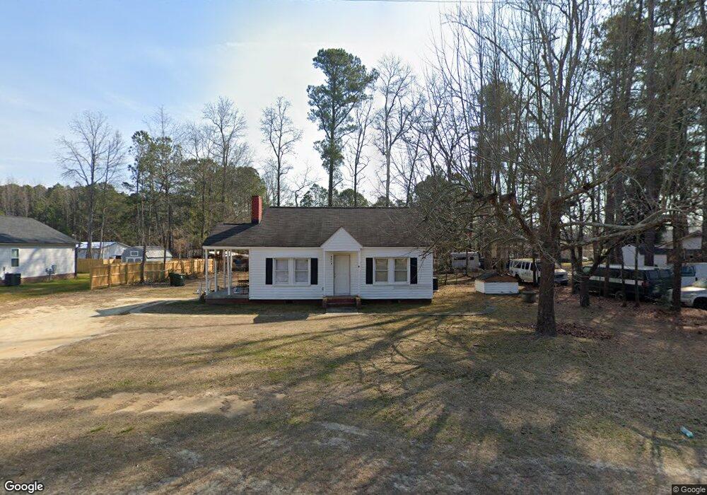
This home is located at 4213 Nc Highway 55 E, Dunn, NC 28334 and is currently estimated at $175,661, approximately $140 per square foot. 4213 Nc Highway 55 E is a home located in Harnett County with nearby schools including Erwin Elementary School, Gentry Primary, and Coats-Erwin Middle School.
Ownership History
Date
Name
Owned For
Owner Type
Purchase Details
Closed on
Jan 24, 2023
Sold by
Cooper Mr
Bought by
Young Durwood
Current Estimated Value
Purchase Details
Closed on
Oct 25, 2022
Sold by
Benoit Susan R
Bought by
Cooper Mr
Purchase Details
Closed on
Jan 12, 2018
Sold by
Johnson Joseph P and Johnson Yvonne W
Bought by
Coats Kenneth and Coats Valarie
Home Financials for this Owner
Home Financials are based on the most recent Mortgage that was taken out on this home.
Original Mortgage
$90,909
Interest Rate
3.9%
Mortgage Type
New Conventional
Purchase Details
Closed on
Apr 28, 2006
Sold by
Pope Wiley J and Estate Of Kenneth M Williams
Bought by
Johnson Joseph P and Johnson Yvonne M
Create a Home Valuation Report for This Property
The Home Valuation Report is an in-depth analysis detailing your home's value as well as a comparison with similar homes in the area
Home Values in the Area
Average Home Value in this Area
Purchase History
| Date | Buyer | Sale Price | Title Company |
|---|---|---|---|
| Young Durwood | $87,000 | -- | |
| Young Durwood | $87,000 | None Listed On Document | |
| Cooper Mr | $75,600 | -- | |
| Coats Kenneth | $90,000 | None Available | |
| Johnson Joseph P | $35,000 | None Available |
Source: Public Records
Mortgage History
| Date | Status | Borrower | Loan Amount |
|---|---|---|---|
| Previous Owner | Coats Kenneth | $90,909 |
Source: Public Records
Tax History Compared to Growth
Tax History
| Year | Tax Paid | Tax Assessment Tax Assessment Total Assessment is a certain percentage of the fair market value that is determined by local assessors to be the total taxable value of land and additions on the property. | Land | Improvement |
|---|---|---|---|---|
| 2025 | $679 | $85,400 | $0 | $0 |
| 2024 | $671 | $85,400 | $0 | $0 |
| 2023 | $603 | $85,400 | $0 | $0 |
| 2022 | $603 | $85,400 | $0 | $0 |
| 2021 | $603 | $61,350 | $0 | $0 |
| 2020 | $603 | $61,350 | $0 | $0 |
| 2019 | $588 | $61,350 | $0 | $0 |
| 2018 | $582 | $61,350 | $0 | $0 |
| 2017 | $582 | $61,350 | $0 | $0 |
| 2015 | -- | $76,380 | $0 | $0 |
| 2014 | -- | $76,380 | $0 | $0 |
Source: Public Records
Map
Nearby Homes
- 610 Maynard Lake Rd
- 183 Boston River Dr Unit (Lot 34)
- 82 Boston River Dr Unit (Lot 4)
- 102 Boston River Dr Unit (Lot 5)
- 102 Boston River Dr
- 165 Boston River Dr Unit (Lot 35)
- 123 Maple Dr
- 163 Maple Dr
- 143 Boston River Dr
- 141 Maple Dr
- 142 Boston River Dr
- 124 Boston River Dr
- 101A Barnes Dr
- 77 Boston River Dr
- 164 Boston River Dr
- 184 Boston River Dr
- 37 Boston River Dr