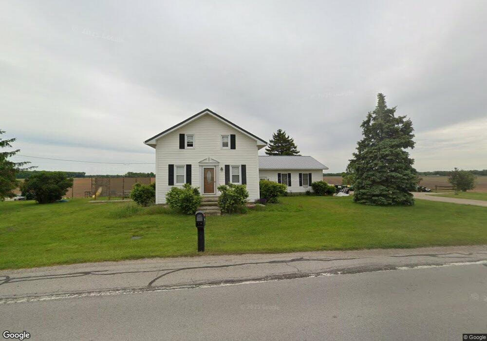
4216 State Route 99 N Monroeville, OH 44847
Estimated Value: $180,010 - $216,000
3
Beds
1
Bath
1,512
Sq Ft
$129/Sq Ft
Est. Value
About This Home
This home is located at 4216 State Route 99 N, Monroeville, OH 44847 and is currently estimated at $195,003, approximately $128 per square foot. 4216 State Route 99 N is a home located in Huron County with nearby schools including Monroeville Elementary School, Monroeville High School, and St Joseph Catholic School.
Ownership History
Date
Name
Owned For
Owner Type
Purchase Details
Closed on
Mar 3, 2005
Bought by
Nickoli Christopher M and Nickoli Monica A
Current Estimated Value
Purchase Details
Closed on
Jun 30, 2004
Bought by
National City Bank
Purchase Details
Closed on
Apr 14, 2003
Bought by
Cline Thomas W
Purchase Details
Closed on
Aug 11, 2000
Bought by
Cline Thomas W
Purchase Details
Closed on
Nov 2, 1995
Sold by
Shrf Thomas W Cline Pr
Bought by
Cline Thomas W
Home Financials for this Owner
Home Financials are based on the most recent Mortgage that was taken out on this home.
Original Mortgage
$65,650
Interest Rate
7.14%
Mortgage Type
New Conventional
Create a Home Valuation Report for This Property
The Home Valuation Report is an in-depth analysis detailing your home's value as well as a comparison with similar homes in the area
Home Values in the Area
Average Home Value in this Area
Purchase History
| Date | Buyer | Sale Price | Title Company |
|---|---|---|---|
| Nickoli Christopher M | $105,500 | -- | |
| National City Bank | $81,300 | -- | |
| Cline Thomas W | -- | -- | |
| Cline Thomas W | -- | -- | |
| Cline Thomas W | $71,800 | -- | |
| Cline Thomas W | $71,800 | -- |
Source: Public Records
Mortgage History
| Date | Status | Borrower | Loan Amount |
|---|---|---|---|
| Previous Owner | Cline Thomas W | $65,650 |
Source: Public Records
Tax History Compared to Growth
Tax History
| Year | Tax Paid | Tax Assessment Tax Assessment Total Assessment is a certain percentage of the fair market value that is determined by local assessors to be the total taxable value of land and additions on the property. | Land | Improvement |
|---|---|---|---|---|
| 2024 | $2,228 | $56,570 | $8,930 | $47,640 |
| 2023 | $2,228 | $45,620 | $6,930 | $38,690 |
| 2022 | $1,931 | $45,620 | $6,930 | $38,690 |
| 2021 | $1,886 | $45,620 | $6,930 | $38,690 |
| 2020 | $1,457 | $33,710 | $5,600 | $28,110 |
| 2019 | $1,443 | $33,710 | $5,600 | $28,110 |
| 2018 | $1,383 | $33,710 | $5,600 | $28,110 |
| 2017 | $1,276 | $31,790 | $5,600 | $26,190 |
| 2016 | $1,250 | $31,790 | $5,600 | $26,190 |
| 2015 | $1,279 | $31,800 | $5,600 | $26,200 |
| 2014 | $1,062 | $29,300 | $5,600 | $23,700 |
| 2013 | $1,135 | $29,300 | $5,600 | $23,700 |
Source: Public Records
Map
Nearby Homes
- 4259 State Route 99 N
- 1531 W Old Sr 20
- 4375 State Route 99 N
- 320 Sandusky St
- 4390 State Route 99 N
- 289 Sandusky St
- 4391 State Route 99 N
- 192 Ridge St N
- 190 Ridge St N
- 272 Sandusky St
- 266 Sandusky St
- 260 Sandusky St
- 276 Sandusky St
- 153 Ridge St N
- 143 Ridge St N
- 135 Ridge St N
- 4516 State Route 99 N
- 15 Fort Monroeville Industrial Pkwy
- 129 Ridge St N
- 4517 State Route 99 N