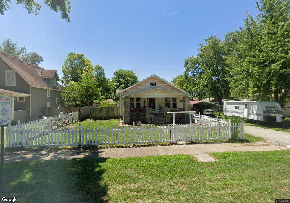
423 Main St Linwood, KS 66052
Estimated Value: $216,000 - $255,000
3
Beds
2
Baths
1,472
Sq Ft
$156/Sq Ft
Est. Value
About This Home
This home is located at 423 Main St, Linwood, KS 66052 and is currently estimated at $229,125, approximately $155 per square foot. 423 Main St is a home located in Leavenworth County with nearby schools including Linwood Elementary School, Basehor-Linwood Middle School, and Basehor-Linwood High School.
Ownership History
Date
Name
Owned For
Owner Type
Purchase Details
Closed on
Aug 29, 2025
Sold by
White Russell W and White Jennifer M
Bought by
White Russell W and White Jennifer M
Current Estimated Value
Purchase Details
Closed on
May 21, 2007
Sold by
Federal Home Loan Mtg Corp
Bought by
Russell White W
Home Financials for this Owner
Home Financials are based on the most recent Mortgage that was taken out on this home.
Original Mortgage
$98,900
Interest Rate
3.83%
Mortgage Type
New Conventional
Create a Home Valuation Report for This Property
The Home Valuation Report is an in-depth analysis detailing your home's value as well as a comparison with similar homes in the area
Home Values in the Area
Average Home Value in this Area
Purchase History
| Date | Buyer | Sale Price | Title Company |
|---|---|---|---|
| White Russell W | -- | None Listed On Document | |
| Russell White W | $131,537 | First American Title |
Source: Public Records
Mortgage History
| Date | Status | Borrower | Loan Amount |
|---|---|---|---|
| Previous Owner | Russell White W | $98,900 | |
| Closed | Russell White W | $98,900 |
Source: Public Records
Tax History Compared to Growth
Tax History
| Year | Tax Paid | Tax Assessment Tax Assessment Total Assessment is a certain percentage of the fair market value that is determined by local assessors to be the total taxable value of land and additions on the property. | Land | Improvement |
|---|---|---|---|---|
| 2025 | $2,644 | $20,095 | $1,838 | $18,257 |
| 2024 | $2,441 | $19,510 | $1,838 | $17,672 |
| 2023 | $2,441 | $19,127 | $1,838 | $17,289 |
| 2022 | $2,257 | $17,078 | $1,378 | $15,700 |
| 2021 | $2,010 | $14,957 | $1,148 | $13,809 |
| 2020 | $1,930 | $14,111 | $1,027 | $13,084 |
| 2019 | $1,694 | $12,266 | $1,027 | $11,239 |
| 2018 | $1,484 | $10,895 | $1,027 | $9,868 |
| 2017 | $1,372 | $10,171 | $1,027 | $9,144 |
| 2016 | $1,374 | $9,959 | $1,027 | $8,932 |
| 2015 | $1,365 | $9,959 | $1,027 | $8,932 |
| 2014 | $1,379 | $9,959 | $1,027 | $8,932 |
Source: Public Records
Map
Nearby Homes
- 0 5 Street Ct
- 00000 Bridge Oak St
- 0000 Park St
- 0 Golden Rd Unit HMS2559950
- 0 Golden Rd Unit 23524027
- Tract 4 Golden Rd
- 00000 174th St
- 11374 198th St
- Lot 5 206th St
- 00000 Lot 9 South 206th St
- 00000 Lot 8 South 206th St
- 00000 Lot 2 North 206th St
- Parcel 5A SE Stanley Rd
- Parcel 4A SE Stanley Rd
- Parcel 3A SE Stanley Rd
- 00000 Cantrell Rd
- 13519 185th St
- 0 Cantrell Rd
- 21535 Loring Rd
- 18494 Linwood Rd