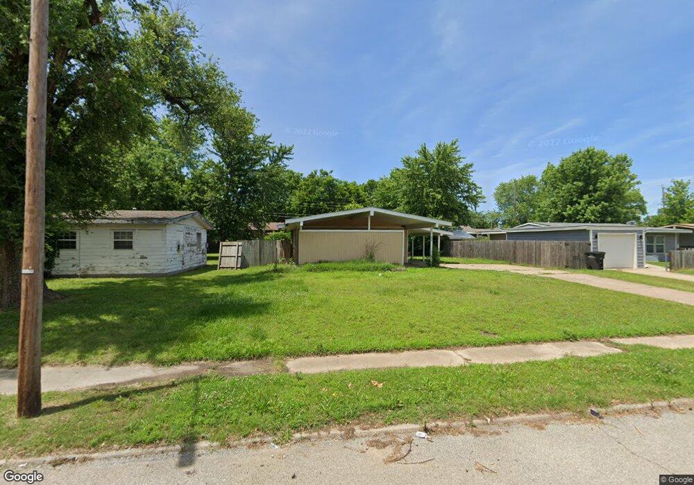
423 Sooner Rd Bartlesville, OK 74003
Estimated Value: $70,000 - $89,000
3
Beds
1
Bath
1,013
Sq Ft
$75/Sq Ft
Est. Value
About This Home
This home is located at 423 Sooner Rd, Bartlesville, OK 74003 and is currently estimated at $75,657, approximately $74 per square foot. 423 Sooner Rd is a home located in Washington County with nearby schools including Woodrow Wilson Elementary School, Central Middle School, and Bartlesville High School.
Ownership History
Date
Name
Owned For
Owner Type
Purchase Details
Closed on
Jul 26, 2013
Sold by
66 Federal Credit Union
Bought by
Dizmang Llc
Current Estimated Value
Purchase Details
Closed on
Jun 11, 2013
Sold by
Sloop Mark L and Sloop Virginia
Bought by
66 Federal Credit Union
Purchase Details
Closed on
Jun 4, 2008
Sold by
Barrett Elizabeth Ann
Bought by
Sloop Mark L
Purchase Details
Closed on
Mar 22, 2005
Sold by
Sloop Crystal
Bought by
Sloop Mark
Purchase Details
Closed on
Jun 30, 1998
Sold by
Stimpson Ernest W Or
Purchase Details
Closed on
Feb 15, 1995
Sold by
Olson George A and Olson Dorothy M
Purchase Details
Closed on
Oct 28, 1994
Sold by
Skeen Andrew E and Skeen Estalene J
Create a Home Valuation Report for This Property
The Home Valuation Report is an in-depth analysis detailing your home's value as well as a comparison with similar homes in the area
Home Values in the Area
Average Home Value in this Area
Purchase History
| Date | Buyer | Sale Price | Title Company |
|---|---|---|---|
| Dizmang Llc | $5,000 | None Available | |
| 66 Federal Credit Union | $30,755 | None Available | |
| Sloop Mark L | $20,000 | None Available | |
| Sloop Mark | -- | None Available | |
| -- | -- | -- | |
| -- | $17,000 | -- | |
| -- | $17,500 | -- |
Source: Public Records
Tax History
| Year | Tax Paid | Tax Assessment Tax Assessment Total Assessment is a certain percentage of the fair market value that is determined by local assessors to be the total taxable value of land and additions on the property. | Land | Improvement |
|---|---|---|---|---|
| 2025 | $422 | $3,517 | $568 | $2,949 |
| 2024 | $402 | $3,350 | $541 | $2,809 |
| 2023 | $380 | $3,190 | $511 | $2,679 |
| 2022 | $364 | $3,190 | $511 | $2,679 |
| 2021 | $339 | $2,894 | $456 | $2,438 |
| 2020 | $331 | $2,756 | $430 | $2,326 |
| 2019 | $315 | $2,624 | $405 | $2,219 |
| 2018 | $299 | $2,500 | $382 | $2,118 |
| 2017 | $291 | $2,381 | $360 | $2,021 |
| 2016 | $273 | $2,381 | $360 | $2,021 |
| 2015 | $277 | $2,381 | $360 | $2,021 |
| 2014 | $280 | $2,381 | $360 | $2,021 |
Source: Public Records
Map
Nearby Homes
- 504 Highland Dr
- 507 Highland Dr
- 409 Highland Dr
- 408 Cumberland Dr
- 421 Oak Park Rd
- 709 Brentwood Rd
- 127 Forrest Park Rd
- 117 Mockingbird Ln
- 518 Carol Rd
- 981 N Virginia Ave
- 320 N Margarite Ave
- 237 N Rogers Ave
- 116 NW Cass Ave
- 116 N Seminole Ave
- 216 S Cheyenne Ave
- 514 S Morton Ave
- 100 N Dewey Ave
- 16640 Oklahoma 123
- 703 S Rogers Ave
- 805 SW Adams Blvd
Your Personal Tour Guide
Ask me questions while you tour the home.