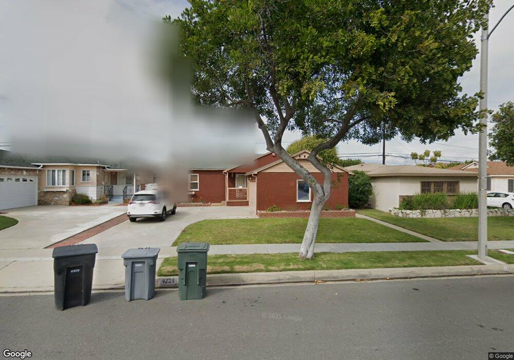
4235 W 176th St Torrance, CA 90504
North Torrance NeighborhoodEstimated Value: $934,000 - $1,046,000
3
Beds
2
Baths
1,114
Sq Ft
$899/Sq Ft
Est. Value
About This Home
This home is located at 4235 W 176th St, Torrance, CA 90504 and is currently estimated at $1,001,016, approximately $898 per square foot. 4235 W 176th St is a home located in Los Angeles County with nearby schools including Edison Elementary School, Philip Magruder Middle School, and North High School.
Ownership History
Date
Name
Owned For
Owner Type
Purchase Details
Closed on
May 22, 2007
Sold by
Kasmani Abdul S and Kasmani Farida S
Bought by
Kasmani Abdul S
Current Estimated Value
Purchase Details
Closed on
Jun 25, 2003
Sold by
Reddington Randel D and Reddington Jone Marie
Bought by
Kasmani Abdul S
Home Financials for this Owner
Home Financials are based on the most recent Mortgage that was taken out on this home.
Original Mortgage
$332,000
Interest Rate
4.75%
Mortgage Type
Purchase Money Mortgage
Purchase Details
Closed on
Jan 7, 1994
Sold by
Braithwaite Norma W
Bought by
Reddington Randel D
Home Financials for this Owner
Home Financials are based on the most recent Mortgage that was taken out on this home.
Original Mortgage
$181,800
Interest Rate
7.21%
Create a Home Valuation Report for This Property
The Home Valuation Report is an in-depth analysis detailing your home's value as well as a comparison with similar homes in the area
Home Values in the Area
Average Home Value in this Area
Purchase History
| Date | Buyer | Sale Price | Title Company |
|---|---|---|---|
| Kasmani Abdul S | -- | None Available | |
| Kasmani Abdul S | $415,000 | -- | |
| Reddington Randel D | $202,000 | World Title Company |
Source: Public Records
Mortgage History
| Date | Status | Borrower | Loan Amount |
|---|---|---|---|
| Previous Owner | Kasmani Abdul S | $332,000 | |
| Previous Owner | Reddington Randel D | $181,800 | |
| Closed | Kasmani Abdul S | $41,500 |
Source: Public Records
Tax History Compared to Growth
Tax History
| Year | Tax Paid | Tax Assessment Tax Assessment Total Assessment is a certain percentage of the fair market value that is determined by local assessors to be the total taxable value of land and additions on the property. | Land | Improvement |
|---|---|---|---|---|
| 2025 | $6,726 | $590,027 | $471,459 | $118,568 |
| 2024 | $6,726 | $578,459 | $462,215 | $116,244 |
| 2023 | $6,603 | $567,117 | $453,152 | $113,965 |
| 2022 | $6,513 | $555,998 | $444,267 | $111,731 |
| 2021 | $6,394 | $545,097 | $435,556 | $109,541 |
| 2019 | $6,208 | $528,931 | $422,638 | $106,293 |
| 2018 | $6,003 | $518,560 | $414,351 | $104,209 |
| 2016 | $5,736 | $498,425 | $398,262 | $100,163 |
| 2015 | $5,611 | $490,939 | $392,280 | $98,659 |
| 2014 | $5,466 | $481,323 | $384,596 | $96,727 |
Source: Public Records
Map
Nearby Homes
- 4223 Artesia Blvd
- 4114 Artesia Blvd
- 4019 W 176th St
- 4147 W 172nd St
- North Pointe Plan at North Pointe
- 4101 W 184th St
- 18204 Kingsdale Ave
- 17805 Florwood Ave
- 3838 W 176th Ct
- 2750 Artesia Blvd Unit 364
- 2750 Artesia Blvd Unit 341
- 18413 Burin Ave
- 17820 Florwood Ave
- 4600 W 170th St
- 4623 W 171st St
- 4313 W 167th St
- 3910 W 182nd St Unit 1
- 2719 Grant Ave Unit C
- 18406 Kingsdale Ave
- 17022 Condon Ave
- 4239 W 176th St
- 4231 W 176th St
- 4232 W 175th Place
- 4243 W 176th St
- 4227 W 176th St
- 4228 W 175th Place
- 4236 W 175th Place
- 4224 W 175th Place
- 4234 W 176th St
- 4223 W 176th St
- 4303 W 176th St
- 4240 W 175th Place
- 4238 W 176th St
- 4230 W 176th St
- 4226 W 176th St
- 4242 W 176th St
- 4220 W 175th Place
- 4307 W 176th St
- 4219 W 176th St
- 4222 W 176th St