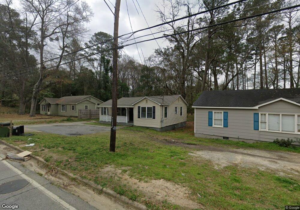
4238 Forrest Rd Columbus, GA 31907
East Columbus NeighborhoodEstimated Value: $103,000 - $139,000
3
Beds
2
Baths
1,176
Sq Ft
$103/Sq Ft
Est. Value
About This Home
This home is located at 4238 Forrest Rd, Columbus, GA 31907 and is currently estimated at $120,644, approximately $102 per square foot. 4238 Forrest Rd is a home located in Muscogee County with nearby schools including Davis Elementary School, Fort Middle School, and Hardaway High School.
Ownership History
Date
Name
Owned For
Owner Type
Purchase Details
Closed on
Oct 5, 2022
Sold by
A-Dell Properties Inc
Bought by
Sfr3-080 Llc
Current Estimated Value
Purchase Details
Closed on
Jul 20, 2022
Sold by
Ryan Cooper Dustin
Bought by
A-Dell Properties Inc
Purchase Details
Closed on
Aug 3, 2021
Sold by
Tax Comm And Ex Officio Sheriff
Bought by
Cooper Dustin Ryan
Purchase Details
Closed on
Oct 24, 2012
Sold by
Upshaw Della
Bought by
A Dell Properties Llc
Purchase Details
Closed on
Jul 29, 2009
Sold by
Barwick John O
Bought by
Upshaw Della
Create a Home Valuation Report for This Property
The Home Valuation Report is an in-depth analysis detailing your home's value as well as a comparison with similar homes in the area
Home Values in the Area
Average Home Value in this Area
Purchase History
| Date | Buyer | Sale Price | Title Company |
|---|---|---|---|
| Sfr3-080 Llc | $52,000 | -- | |
| A-Dell Properties Inc | $13,400 | Coleman John H | |
| A-Dell Properties Inc | $13,400 | Coleman John H | |
| Cooper Dustin Ryan | $10,000 | -- | |
| A Dell Properties Llc | -- | -- | |
| Upshaw Della | $20,000 | None Available |
Source: Public Records
Tax History
| Year | Tax Paid | Tax Assessment Tax Assessment Total Assessment is a certain percentage of the fair market value that is determined by local assessors to be the total taxable value of land and additions on the property. | Land | Improvement |
|---|---|---|---|---|
| 2025 | $1,759 | $44,948 | $10,596 | $34,352 |
| 2024 | $176 | $44,948 | $10,596 | $34,352 |
| 2023 | $126 | $38,816 | $10,596 | $28,220 |
| 2022 | $1,307 | $32,020 | $7,960 | $24,060 |
| 2021 | $1,167 | $25,532 | $7,960 | $17,572 |
| 2020 | $1,043 | $25,532 | $7,960 | $17,572 |
| 2019 | $1,046 | $25,532 | $7,960 | $17,572 |
| 2018 | $1,046 | $25,532 | $7,960 | $17,572 |
| 2017 | $3,934 | $25,532 | $7,960 | $17,572 |
| 2016 | $740 | $17,941 | $2,566 | $15,375 |
| 2015 | $296 | $17,941 | $2,566 | $15,375 |
| 2014 | $297 | $17,941 | $2,566 | $15,375 |
| 2013 | -- | $17,941 | $2,566 | $15,375 |
Source: Public Records
Map
Nearby Homes
- 4250 Adams St
- 4201 Forrest Rd
- 2218 Avalon Rd
- 4221 Adams St
- 4135 Forrest Rd
- 911 Lamore St
- 4222 Fort St
- 4229 Barr St
- 4384 Forrest Rd
- 4390 Forrest Rd
- 4396 Forrest Rd
- 4402 Forrest Rd
- 4410 Forrest Rd
- 3946 Forestside Dr
- 4160 Spirea Dr
- 1650 Berkley Ave
- 2608 Juniper Ave
- 1658 Forestside Dr
- 1647 Berkley Ave
- 4312 Old MacOn Rd Unit 2
- 4234 Forrest Rd
- 4242 Forrest Rd
- 4226 Forrest Rd
- 4224 Forrest Rd
- 4239 Forrest Rd
- 4233 Forrest Rd
- 4247 Forrest Rd
- 4254 Forrest Rd
- 4220 Forrest Rd
- 4225 Forrest Rd
- 4255 Forrest Rd
- 4214 Forrest Rd
- 4219 Forrest Rd
- 2129 Reese Rd
- 4258 Forrest Rd
- 4261 Forrest Rd
- 4215 Forrest Rd
- 2125 Reese Rd
- 4246 Adams St
- 4240 Adams St
Your Personal Tour Guide
Ask me questions while you tour the home.