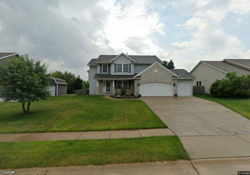
4247 Palm Dr Bettendorf, IA 52722
Estimated Value: $411,000 - $526,000
4
Beds
3
Baths
2,134
Sq Ft
$211/Sq Ft
Est. Value
About This Home
This home is located at 4247 Palm Dr, Bettendorf, IA 52722 and is currently estimated at $450,743, approximately $211 per square foot. 4247 Palm Dr is a home located in Scott County with nearby schools including Hopewell Elementary, Pleasant Valley Junior High School, and Pleasant Valley High School.
Ownership History
Date
Name
Owned For
Owner Type
Purchase Details
Closed on
Aug 28, 2006
Sold by
Beaver Builders Inc
Bought by
Lowther William R and Lowther Veronica
Current Estimated Value
Home Financials for this Owner
Home Financials are based on the most recent Mortgage that was taken out on this home.
Original Mortgage
$43,100
Interest Rate
6.7%
Mortgage Type
Stand Alone Second
Create a Home Valuation Report for This Property
The Home Valuation Report is an in-depth analysis detailing your home's value as well as a comparison with similar homes in the area
Home Values in the Area
Average Home Value in this Area
Purchase History
| Date | Buyer | Sale Price | Title Company |
|---|---|---|---|
| Lowther William R | $288,000 | None Available | |
| Beaver Builders Inc | -- | None Available |
Source: Public Records
Mortgage History
| Date | Status | Borrower | Loan Amount |
|---|---|---|---|
| Previous Owner | Lowther William R | $43,100 | |
| Previous Owner | Lowther William R | $230,183 |
Source: Public Records
Tax History Compared to Growth
Tax History
| Year | Tax Paid | Tax Assessment Tax Assessment Total Assessment is a certain percentage of the fair market value that is determined by local assessors to be the total taxable value of land and additions on the property. | Land | Improvement |
|---|---|---|---|---|
| 2025 | $4,994 | $404,000 | $82,200 | $321,800 |
| 2024 | $5,280 | $356,800 | $52,400 | $304,400 |
| 2023 | $5,454 | $356,800 | $52,400 | $304,400 |
| 2022 | $5,396 | $312,020 | $52,380 | $259,640 |
| 2021 | $5,396 | $312,020 | $52,380 | $259,640 |
| 2020 | $5,088 | $296,680 | $52,380 | $244,300 |
| 2019 | $5,156 | $285,040 | $52,380 | $232,660 |
| 2018 | $5,052 | $285,040 | $52,380 | $232,660 |
| 2017 | $1,567 | $285,040 | $52,380 | $232,660 |
| 2016 | $5,018 | $278,680 | $0 | $0 |
| 2015 | $5,018 | $266,930 | $0 | $0 |
| 2014 | $4,860 | $266,930 | $0 | $0 |
| 2013 | $4,770 | $0 | $0 | $0 |
| 2012 | -- | $269,230 | $43,660 | $225,570 |
Source: Public Records
Map
Nearby Homes
- 6239 Morgan Ct
- 6451 Friendship Path
- 5924 Joshua St
- 6262 Wildberry Dr
- Lot 28 Wildcat Way
- Lot 29 Wildcat Way
- 5606 Emily Rd
- Lot 50 Polster Place
- 5934 Butterfield Dr
- 5922 Butterfield Dr
- Lot 51 Polster Place
- 5900 Butterfield Dr
- 3405 Marynoel Ave
- 5940 Butterfield Dr
- 5882 Butterfield Dr
- 5931 Butterfield Dr
- 5925 Butterfield Dr
- 5937 Butterfield Dr
- 5885 Butterfield Dr
- 5919 Butterfield Dr
- 4231 Palm Dr
- 4301 Palm Dr
- 6262 Morgan Ct
- 4225 Palm Dr
- 6305 International Dr
- 4357 Palm Dr
- 4211 Palm Dr
- 6304 Ocean Dr
- 6306 International Dr
- 6357 International Dr
- 4415 Palm Dr
- 6244 Morgan Ct
- 6251 Morgan Ct
- 6360 Ocean Blvd
- 6248 Buckskin Trail
- 4453 Palm Dr
- 6407 International Dr
- 6246 Buckskin Trail
- 6303 Ocean Blvd
- 6408 Ocean Blvd