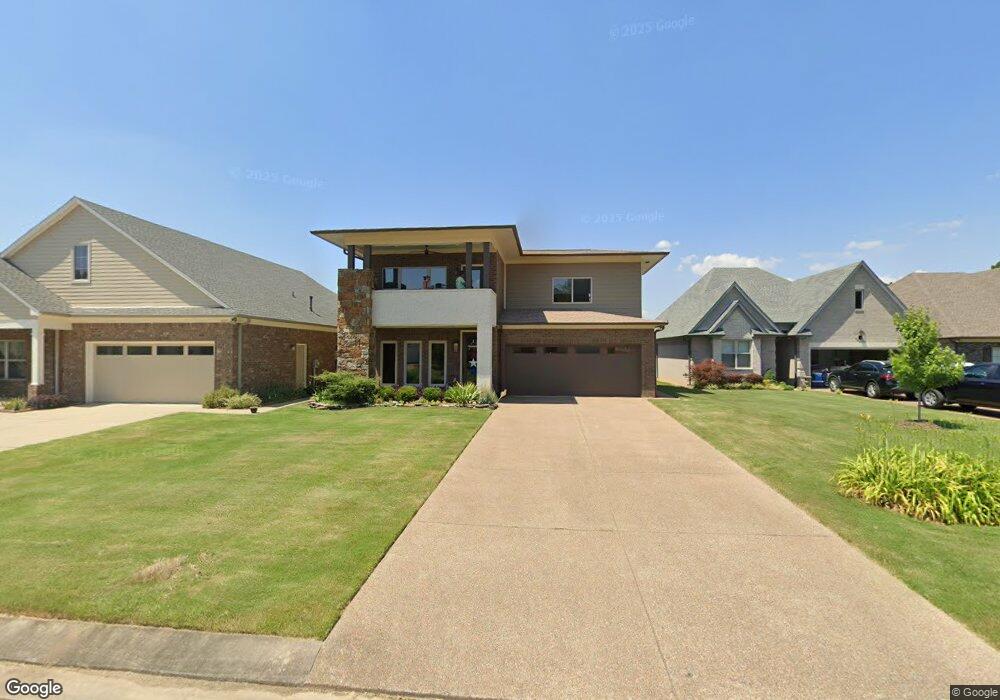
425 Saint Andrews Dr Oakland, TN 38060
Estimated Value: $385,042 - $460,000
--
Bed
1
Bath
2,210
Sq Ft
$187/Sq Ft
Est. Value
About This Home
This home is located at 425 Saint Andrews Dr, Oakland, TN 38060 and is currently estimated at $412,511, approximately $186 per square foot. 425 Saint Andrews Dr is a home with nearby schools including Oakland Elementary School, West Junior High School, and Fayette Ware Comprehensive High School.
Ownership History
Date
Name
Owned For
Owner Type
Purchase Details
Closed on
Apr 19, 2016
Sold by
Swan Development Grp Llc
Bought by
Hall James N and Hall Christina L
Current Estimated Value
Home Financials for this Owner
Home Financials are based on the most recent Mortgage that was taken out on this home.
Original Mortgage
$256,500
Interest Rate
3.71%
Mortgage Type
Commercial
Create a Home Valuation Report for This Property
The Home Valuation Report is an in-depth analysis detailing your home's value as well as a comparison with similar homes in the area
Home Values in the Area
Average Home Value in this Area
Purchase History
| Date | Buyer | Sale Price | Title Company |
|---|---|---|---|
| Hall James N | $308,152 | -- |
Source: Public Records
Mortgage History
| Date | Status | Borrower | Loan Amount |
|---|---|---|---|
| Closed | Hall James N | $256,500 |
Source: Public Records
Tax History Compared to Growth
Tax History
| Year | Tax Paid | Tax Assessment Tax Assessment Total Assessment is a certain percentage of the fair market value that is determined by local assessors to be the total taxable value of land and additions on the property. | Land | Improvement |
|---|---|---|---|---|
| 2024 | $1,998 | $77,350 | $10,000 | $67,350 |
| 2023 | $1,998 | $77,350 | $0 | $0 |
| 2022 | $1,325 | $77,350 | $10,000 | $67,350 |
| 2021 | $1,325 | $77,350 | $10,000 | $67,350 |
| 2020 | $1,031 | $77,350 | $10,000 | $67,350 |
| 2019 | $1,388 | $68,375 | $7,500 | $60,875 |
| 2018 | $1,428 | $68,375 | $7,500 | $60,875 |
| 2017 | $1,217 | $68,375 | $7,500 | $60,875 |
| 2016 | $107 | $5,625 | $5,625 | $0 |
| 2015 | $107 | $5,625 | $5,625 | $0 |
| 2014 | $107 | $5,625 | $5,625 | $0 |
Source: Public Records
Map
Nearby Homes
- 360 Saint Andrews Dr
- 300 Saint Andrews Dr
- 290 Saint Andrews Dr
- 325 Saint Andrews Dr
- 205 Saint Andrews Dr
- Callahan Plan at Fair Oaks - Villas at Fair Oaks
- Clark Plan at Fair Oaks - Villas at Fair Oaks
- Gibson Plan at Fair Oaks - Villas at Fair Oaks
- 217 Saint Andrews Dr Unit 55-C
- 175 Saint Andrews Dr
- 22 Doral Loop
- 235 Fairoaks Dr
- 75 Fairoaks Dr
- 10 Blackthorn Cove
- 000 Hwy 64
- 270 Oak St
- 160 Aberdeen Dr
- 35 Rolling Oaks Dr
- 115 Lakewood Dr
- 65 Birkdale Dr
- 415 Saint Andrews Dr
- 445 Saint Andrews Dr
- 405 Saint Andrews Dr
- 395 Saint Andrews Dr
- 410 Saint Andrews Dr
- 470 Saint Andrews Dr
- 430 Saint Andrews Dr
- 440 Saint Andrews Dr
- 465 Saint Andrews Dr
- 420 Saint Andrews Way
- 410 Saint Andrews Way Unit 17B
- 385 Saint Andrews Dr
- 475 Saint Andrews Dr
- 450 Saint Andrews Dr
- 450 Saint Andrews Way
- 400 Saint Andrews Dr
- 380 Saint Andrews Dr
- 382 St Andrews Dr
- 382 Saint Andrews Dr
- 460 Saint Andrews Dr