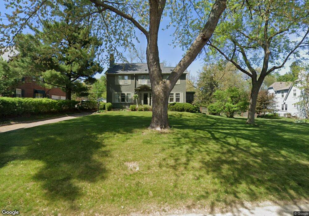
4253 Foster Dr Des Moines, IA 50312
Linden Heights NeighborhoodEstimated Value: $607,000 - $701,000
3
Beds
2
Baths
2,401
Sq Ft
$275/Sq Ft
Est. Value
About This Home
This home is located at 4253 Foster Dr, Des Moines, IA 50312 and is currently estimated at $659,898, approximately $274 per square foot. 4253 Foster Dr is a home located in Polk County with nearby schools including Greenwood Elementary School, Callanan Middle School, and Roosevelt High School.
Ownership History
Date
Name
Owned For
Owner Type
Purchase Details
Closed on
Jul 12, 2007
Sold by
Cerne Joseph M and Cerne Paula M
Bought by
Pennington James M and Pennington Kelley M
Current Estimated Value
Home Financials for this Owner
Home Financials are based on the most recent Mortgage that was taken out on this home.
Original Mortgage
$336,000
Outstanding Balance
$210,450
Interest Rate
6.54%
Mortgage Type
Purchase Money Mortgage
Estimated Equity
$449,448
Purchase Details
Closed on
May 21, 2004
Sold by
Holz Robert F and Hoz Sharon L
Bought by
Cerne Joseph M and Cerne Paula M
Home Financials for this Owner
Home Financials are based on the most recent Mortgage that was taken out on this home.
Original Mortgage
$220,000
Interest Rate
5.91%
Mortgage Type
Purchase Money Mortgage
Create a Home Valuation Report for This Property
The Home Valuation Report is an in-depth analysis detailing your home's value as well as a comparison with similar homes in the area
Home Values in the Area
Average Home Value in this Area
Purchase History
| Date | Buyer | Sale Price | Title Company |
|---|---|---|---|
| Pennington James M | $419,500 | None Available | |
| Cerne Joseph M | $364,500 | -- |
Source: Public Records
Mortgage History
| Date | Status | Borrower | Loan Amount |
|---|---|---|---|
| Open | Pennington James M | $336,000 | |
| Previous Owner | Cerne Joseph M | $220,000 | |
| Closed | Cerne Joseph M | $145,000 |
Source: Public Records
Tax History Compared to Growth
Tax History
| Year | Tax Paid | Tax Assessment Tax Assessment Total Assessment is a certain percentage of the fair market value that is determined by local assessors to be the total taxable value of land and additions on the property. | Land | Improvement |
|---|---|---|---|---|
| 2024 | $9,640 | $500,500 | $100,700 | $399,800 |
| 2023 | $9,722 | $500,500 | $100,700 | $399,800 |
| 2022 | $9,646 | $421,400 | $87,200 | $334,200 |
| 2021 | $9,704 | $421,400 | $87,200 | $334,200 |
| 2020 | $10,076 | $397,500 | $80,100 | $317,400 |
| 2019 | $10,258 | $397,500 | $80,100 | $317,400 |
| 2018 | $10,148 | $390,200 | $77,100 | $313,100 |
| 2017 | $9,100 | $390,200 | $77,100 | $313,100 |
| 2016 | $8,862 | $345,000 | $67,300 | $277,700 |
| 2015 | $8,862 | $345,000 | $67,300 | $277,700 |
| 2014 | $8,798 | $352,500 | $68,400 | $284,100 |
Source: Public Records
Map
Nearby Homes
- 330 42nd St
- 201 Foster Dr
- 4323 Grand Ave Unit 216
- 4323 Grand Ave Unit 324
- 4004 John Lynde Rd
- 4345 Grand Ave Unit 1
- 225 Foster Dr
- 3950 John Lynde Rd
- 529 43rd St
- 4004 Grand Ave Unit 103
- 181 38th Place
- 339 49th St
- 3920 Grand Ave Unit 2TW
- 3920 Grand Ave Unit 5TE
- 4101 Muskogee Ave
- 3934 Lincoln Place Dr
- 303 51st St
- 413 38th Place
- 4820 Grand Ave
- 204 51st St
- 4245 Foster Dr
- 4255 Foster Dr
- 4235 Foster Dr
- 4330 Greenwood Dr
- 4267 Foster Dr
- 4320 Greenwood Dr
- 4334 Greenwood Dr
- 4240 Greenwood Dr
- 4244 Foster Dr
- 4252 Foster Dr
- 4229 Foster Dr
- 4240 Foster Dr
- 5 Foster Dr
- 4230 Greenwood Dr
- 4400 Greenwood Dr
- 2 Foster Dr
- 4230 Foster Dr
- 4219 Foster Dr
- 4222 Greenwood Dr
- 7 Foster Dr