Estimated Value: $374,997 - $450,000
3
Beds
2
Baths
1,408
Sq Ft
$291/Sq Ft
Est. Value
About This Home
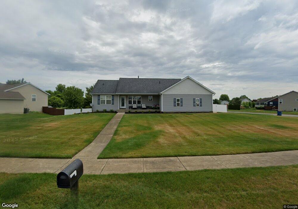
This home is located at 4257 Railside Dr, Dorr, MI 49323 and is currently estimated at $409,249, approximately $290 per square foot. 4257 Railside Dr is a home located in Allegan County with nearby schools including Wayland High School, Byron Center Charter School, and St. Stanislaus School.
Ownership History
Date
Name
Owned For
Owner Type
Purchase Details
Closed on
Aug 26, 2013
Sold by
Vanwynk Michael J
Bought by
Houtman Heather S
Current Estimated Value
Purchase Details
Closed on
Jun 6, 2002
Sold by
Bd Land Company Llc
Bought by
Andres Brothers Construction
Home Financials for this Owner
Home Financials are based on the most recent Mortgage that was taken out on this home.
Original Mortgage
$150,350
Interest Rate
6.87%
Mortgage Type
Construction
Create a Home Valuation Report for This Property
The Home Valuation Report is an in-depth analysis detailing your home's value as well as a comparison with similar homes in the area
Home Values in the Area
Average Home Value in this Area
Purchase History
| Date | Buyer | Sale Price | Title Company |
|---|---|---|---|
| Houtman Heather S | -- | None Available | |
| Andres Brothers Construction | $33,900 | -- |
Source: Public Records
Mortgage History
| Date | Status | Borrower | Loan Amount |
|---|---|---|---|
| Previous Owner | Andres Brothers Construction | $150,350 |
Source: Public Records
Tax History
| Year | Tax Paid | Tax Assessment Tax Assessment Total Assessment is a certain percentage of the fair market value that is determined by local assessors to be the total taxable value of land and additions on the property. | Land | Improvement |
|---|---|---|---|---|
| 2025 | $3,084 | $179,800 | $46,000 | $133,800 |
| 2024 | $2,790 | $172,400 | $37,900 | $134,500 |
| 2023 | $2,858 | $154,800 | $36,400 | $118,400 |
| 2022 | $2,790 | $140,600 | $31,800 | $108,800 |
| 2021 | $2,628 | $124,300 | $29,400 | $94,900 |
| 2020 | $2,511 | $118,500 | $26,700 | $91,800 |
| 2019 | $2,511 | $110,000 | $16,000 | $94,000 |
| 2018 | $2,455 | $97,400 | $16,000 | $81,400 |
| 2017 | $0 | $97,700 | $16,000 | $81,700 |
| 2016 | $0 | $87,500 | $16,000 | $71,500 |
| 2015 | -- | $87,500 | $16,000 | $71,500 |
| 2014 | -- | $81,300 | $16,500 | $64,800 |
| 2013 | -- | $73,800 | $16,500 | $57,300 |
Source: Public Records
Map
Nearby Homes
- Lots A&B 142nd Ave
- 1341 142nd Ave
- 4087 Gene Ct
- 4035 Patti Rd
- 4069 21st St
- 4185 24th St
- 10780 Windward Ave SW
- 10785 Windward Ave SW
- 10725 Windward Ave SW
- 10711 Windward Ave SW
- Lot A 142nd Ave
- Lot B 142nd Ave
- 4335 Tavistock Dr
- 4230 Fenwick Dr
- 4316 Sussex Place
- 1125 Russell St
- 136 100th St SW
- 737 100th St SW
- 4273 Highpoint Dr Unit 112
- 4269 Highpoint Dr Unit 114
- 1833 Railside Ct
- 1829 Cooke Farms
- 4254 Railside Dr
- 4269 Railside Dr
- 4266 Railside Dr
- 4258 Railside Dr
- 4260 Railside Dr
- 1826 Cooke Farms
- 1829 Railside Ct
- 1840 Railside Ct
- 4270 Railside Dr
- 1825 Railside Ct
- 4275 Railside Dr
- 1825 Cooke Farms Dr
- 1825 Cooke Farms Dr
- 0 Railside Ct Unit LOT 1
- 1836 Railside Ct
- 1820 Cooke Farms
- 1832 Railside Ct
- 4276 Railside Dr
Your Personal Tour Guide
Ask me questions while you tour the home.