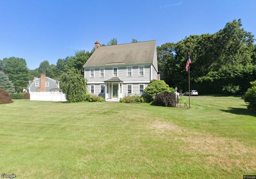
426 Lantern Way Windsor, CT 06095
West Windsor NeighborhoodEstimated Value: $623,402 - $672,000
4
Beds
4
Baths
3,322
Sq Ft
$193/Sq Ft
Est. Value
About This Home
This home is located at 426 Lantern Way, Windsor, CT 06095 and is currently estimated at $641,351, approximately $193 per square foot. 426 Lantern Way is a home located in Hartford County with nearby schools including Poquonock Elementary School, Clover Street School, and Sage Park Middle School.
Ownership History
Date
Name
Owned For
Owner Type
Purchase Details
Closed on
Oct 29, 1997
Sold by
Grothe Mark and Grothe Marcia
Bought by
Alford Leon and Rendock Madeline
Current Estimated Value
Purchase Details
Closed on
Jan 15, 1991
Sold by
Lonergar Michele
Bought by
Grothe Mark and Grothe Marcia
Purchase Details
Closed on
Sep 25, 1987
Sold by
Colonial Bldrs
Bought by
Lonergan Michelle
Create a Home Valuation Report for This Property
The Home Valuation Report is an in-depth analysis detailing your home's value as well as a comparison with similar homes in the area
Home Values in the Area
Average Home Value in this Area
Purchase History
| Date | Buyer | Sale Price | Title Company |
|---|---|---|---|
| Alford Leon | $212,000 | -- | |
| Grothe Mark | $261,000 | -- | |
| Lonergan Michelle | $265,464 | -- |
Source: Public Records
Mortgage History
| Date | Status | Borrower | Loan Amount |
|---|---|---|---|
| Closed | Lonergan Michelle | $75,000 | |
| Closed | Lonergan Michelle | $50,000 | |
| Open | Lonergan Michelle | $135,000 |
Source: Public Records
Tax History
| Year | Tax Paid | Tax Assessment Tax Assessment Total Assessment is a certain percentage of the fair market value that is determined by local assessors to be the total taxable value of land and additions on the property. | Land | Improvement |
|---|---|---|---|---|
| 2025 | $10,499 | $369,040 | $74,550 | $294,490 |
| 2024 | $11,189 | $369,040 | $74,550 | $294,490 |
| 2023 | $8,759 | $260,680 | $58,660 | $202,020 |
| 2022 | $8,673 | $260,680 | $58,660 | $202,020 |
| 2021 | $8,673 | $260,680 | $58,660 | $202,020 |
| 2020 | $8,631 | $260,680 | $58,660 | $202,020 |
| 2019 | $8,269 | $255,360 | $58,660 | $196,700 |
| 2018 | $8,001 | $242,760 | $58,660 | $184,100 |
| 2017 | $6,812 | $209,930 | $58,660 | $151,270 |
| 2016 | $6,617 | $209,930 | $58,660 | $151,270 |
| 2015 | $6,491 | $209,930 | $58,660 | $151,270 |
| 2014 | $6,397 | $209,930 | $58,660 | $151,270 |
Source: Public Records
Map
Nearby Homes
- 10 Cleary Ln
- 24 Mary Catherine Cir
- 16 Hilltop Rd
- 1 Deanne Lynn Cir
- 823 Stone Rd
- 109 Old Village Cir
- 39 Loren Cir
- 22 Eastview Dr
- 999 Stone Rd
- 490 Old Day Hill Rd
- 22 Apple Tree Ln
- 1946 Poquonock Ave
- 25 High St
- 58 Hollow Brook Rd
- 16 Cornfield Rd
- 0 Walnut and Larch Dr
- 485 River St
- 49 Seymour Rd
- 16 Seymour Rd Unit 21C
- 16 Seymour Rd Unit 2H
- 436 Lantern Way
- 418 Lantern Way
- 423 Lantern Way
- 427 Lantern Way
- 440 Lantern Way
- 414 Lantern Way
- 419 Lantern Way
- 433 Lantern Way
- 437 Lantern Way
- 415 Lantern Way
- 510 Hearthstone Dr
- 444 Lantern Way
- 410 Lantern Way
- 505 Hearthstone Dr
- 441 Lantern Way
- 319 Hitching Post Ln
- 509 Hearthstone Dr
- 448 Lantern Way
- 445 Lantern Way
- 315 Hitching Post Ln
Your Personal Tour Guide
Ask me questions while you tour the home.