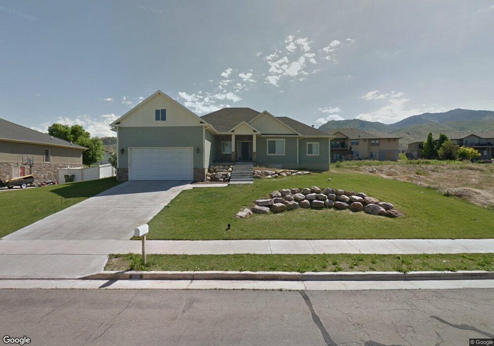
426 S 900 E Smithfield, UT 84335
Estimated Value: $539,000 - $659,000
5
Beds
3
Baths
3,758
Sq Ft
$163/Sq Ft
Est. Value
About This Home
This home is located at 426 S 900 E, Smithfield, UT 84335 and is currently estimated at $612,345, approximately $162 per square foot. 426 S 900 E is a home located in Cache County with nearby schools including Sunrise School, Cedar Ridge School, and North Cache Middle School.
Ownership History
Date
Name
Owned For
Owner Type
Purchase Details
Closed on
Nov 18, 2011
Sold by
Nixon E J and Nixon Charlotte M
Bought by
Nixon & Nixon Inc
Current Estimated Value
Purchase Details
Closed on
Aug 14, 2008
Sold by
Morgan Grant D and Morgan Shalie R
Bought by
Nixon E J
Purchase Details
Closed on
Dec 21, 2007
Sold by
Monarch Homes Inc and Morgan Grant D
Bought by
Morgan Grant D and Morgan Shalie R
Home Financials for this Owner
Home Financials are based on the most recent Mortgage that was taken out on this home.
Original Mortgage
$256,250
Interest Rate
6.21%
Mortgage Type
New Conventional
Purchase Details
Closed on
May 16, 2007
Sold by
Nixon E J
Bought by
Monarch Homes Inc and Morgan Grant D
Home Financials for this Owner
Home Financials are based on the most recent Mortgage that was taken out on this home.
Original Mortgage
$236,225
Interest Rate
6.17%
Mortgage Type
Future Advance Clause Open End Mortgage
Create a Home Valuation Report for This Property
The Home Valuation Report is an in-depth analysis detailing your home's value as well as a comparison with similar homes in the area
Home Values in the Area
Average Home Value in this Area
Purchase History
| Date | Buyer | Sale Price | Title Company |
|---|---|---|---|
| Nixon & Nixon Inc | -- | Northern Title Company | |
| Nixon E J | -- | None Available | |
| Morgan Grant D | -- | Northern Title Company | |
| Monarch Homes Inc | -- | Northern Title Company |
Source: Public Records
Mortgage History
| Date | Status | Borrower | Loan Amount |
|---|---|---|---|
| Previous Owner | Morgan Grant D | $256,250 | |
| Previous Owner | Monarch Homes Inc | $236,225 |
Source: Public Records
Tax History
| Year | Tax Paid | Tax Assessment Tax Assessment Total Assessment is a certain percentage of the fair market value that is determined by local assessors to be the total taxable value of land and additions on the property. | Land | Improvement |
|---|---|---|---|---|
| 2025 | $2,615 | $350,035 | $0 | $0 |
| 2024 | $29 | $359,915 | $0 | $0 |
| 2023 | $3,000 | $356,345 | $0 | $0 |
| 2022 | $305 | $356,345 | $0 | $0 |
| 2021 | $2,578 | $460,298 | $75,000 | $385,298 |
| 2020 | $2,462 | $410,042 | $75,000 | $335,042 |
| 2019 | $2,482 | $394,042 | $59,000 | $335,042 |
| 2018 | $2,333 | $358,145 | $59,000 | $299,145 |
| 2017 | $2,255 | $189,145 | $0 | $0 |
| 2016 | $2,295 | $166,940 | $0 | $0 |
| 2015 | $2,034 | $166,940 | $0 | $0 |
| 2014 | $1,991 | $166,665 | $0 | $0 |
| 2013 | -- | $166,665 | $0 | $0 |
Source: Public Records
Map
Nearby Homes
- 127 S 830 E Unit 304
- 434 S Cardon Ridge Dr
- 1092 E 300 S
- 413 S 1150 E Unit 1101
- 577 S 1140 E Unit 1202
- 641 S 1080 E Unit 44
- 12 S 1150 E Unit 8
- 670 S 1080 E Unit 37
- 628 S 1080 E
- 722 S 1040 E Unit 21
- 738 S 1150 E Unit 9
- 776 S 1150 E
- 111 S 1250 E
- 2 S 1200 E Unit 15
- 442 S 455 E
- 396 S 455 E
- 13 N 1150 E
- 139 Fairway Dr
- 125 Fairway Dr
- 641 S 380 E
Your Personal Tour Guide
Ask me questions while you tour the home.