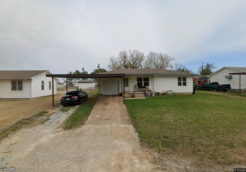
426 S Main St McLoud, OK 74851
Estimated Value: $81,427 - $136,000
2
Beds
1
Bath
782
Sq Ft
$126/Sq Ft
Est. Value
About This Home
This home is located at 426 S Main St, McLoud, OK 74851 and is currently estimated at $98,607, approximately $126 per square foot. 426 S Main St is a home located in Pottawatomie County with nearby schools including McLoud Intermediate School, McLoud Elementary School, and McLoud Junior High School.
Ownership History
Date
Name
Owned For
Owner Type
Purchase Details
Closed on
Mar 24, 2025
Sold by
Mauldin Shelley R
Bought by
Jarod W And Shelley R Mauldin Revocable Trust and Mauldin
Current Estimated Value
Purchase Details
Closed on
Sep 17, 2021
Sold by
Williams Danny D and Williams Donna J
Bought by
Mauldin Shelley R
Purchase Details
Closed on
Oct 20, 2006
Sold by
Akins Gary J and Akins Barbara
Bought by
Williams Danny D and Williams Donna J
Home Financials for this Owner
Home Financials are based on the most recent Mortgage that was taken out on this home.
Original Mortgage
$42,300
Interest Rate
6.28%
Mortgage Type
Purchase Money Mortgage
Purchase Details
Closed on
Nov 22, 2002
Sold by
Akins Opal Lucille and Akins Gary J
Bought by
Akins Gary J
Purchase Details
Closed on
Dec 27, 1991
Sold by
Akins Opal
Bought by
Akins Opal and Akins Gary
Create a Home Valuation Report for This Property
The Home Valuation Report is an in-depth analysis detailing your home's value as well as a comparison with similar homes in the area
Home Values in the Area
Average Home Value in this Area
Purchase History
| Date | Buyer | Sale Price | Title Company |
|---|---|---|---|
| Jarod W And Shelley R Mauldin Revocable Trust | -- | None Listed On Document | |
| Mauldin Shelley R | $60,000 | First American Title Ins Co | |
| Williams Danny D | $47,000 | Stewart Escrow & Title Midwe | |
| Akins Gary J | -- | None Available | |
| Akins Opal | -- | -- |
Source: Public Records
Mortgage History
| Date | Status | Borrower | Loan Amount |
|---|---|---|---|
| Previous Owner | Williams Danny D | $42,300 |
Source: Public Records
Tax History
| Year | Tax Paid | Tax Assessment Tax Assessment Total Assessment is a certain percentage of the fair market value that is determined by local assessors to be the total taxable value of land and additions on the property. | Land | Improvement |
|---|---|---|---|---|
| 2025 | $588 | $7,639 | $503 | $7,136 |
| 2024 | $564 | $7,415 | $488 | $6,927 |
| 2023 | $564 | $7,200 | $448 | $6,752 |
| 2022 | $571 | $7,200 | $448 | $6,752 |
| 2021 | $599 | $4,994 | $450 | $4,544 |
| 2020 | $461 | $4,994 | $450 | $4,544 |
| 2019 | $475 | $4,994 | $450 | $4,544 |
| 2018 | $495 | $4,899 | $450 | $4,449 |
| 2017 | $478 | $4,666 | $450 | $4,216 |
| 2016 | $408 | $4,444 | $450 | $3,994 |
| 2015 | $382 | $4,233 | $450 | $3,783 |
| 2014 | $382 | $4,304 | $450 | $3,854 |
Source: Public Records
Map
Nearby Homes
- 400 S Main St
- 211 S 6th St
- 141 Folsom Dr
- 827 W Broadway Ave
- 0 Thomas Blvd Unit 1205900
- 922 W Hinchley Ave
- 13430 Dewberry Rd
- 13421 Juneberry Dr
- 13429 Juneberry Dr
- 30280 Stephens Dr
- 29805 SE 29th St
- 113 Summer Oaks Dr
- 101 W Oak Hill Dr
- 3129 Janet Ln Unit HAR
- 115 Thornbrue Dr
- 22072 Melissa Ln
- 0 SE 74th St
- 9202 Cleo Ln
- 22085 Melissa Ln
- 114 Timber Lake Dr
Your Personal Tour Guide
Ask me questions while you tour the home.