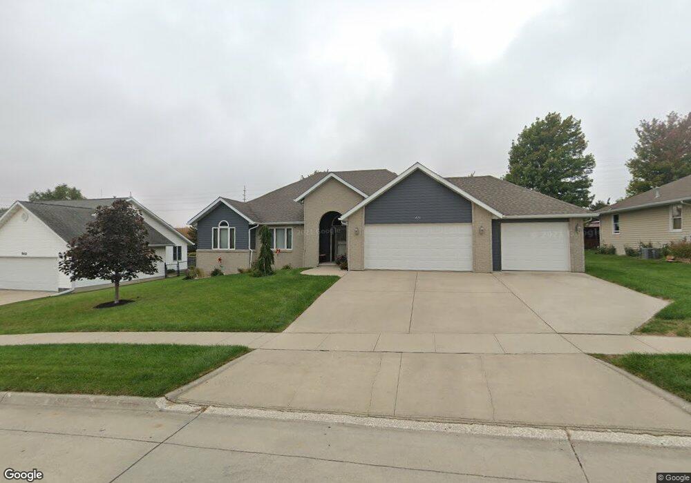
426 Westridge Dr Carroll, IA 51401
Estimated Value: $379,000 - $406,456
4
Beds
2
Baths
1,737
Sq Ft
$228/Sq Ft
Est. Value
About This Home
This home is located at 426 Westridge Dr, Carroll, IA 51401 and is currently estimated at $395,614, approximately $227 per square foot. 426 Westridge Dr is a home with nearby schools including Fairview Elementary School, Adams Elementary School, and Carroll Middle School.
Ownership History
Date
Name
Owned For
Owner Type
Purchase Details
Closed on
Jun 7, 2009
Sold by
Mollhoff Travis R and Mollhoff Danielle H
Bought by
Andersen Glen E and Andersen Jan D
Current Estimated Value
Home Financials for this Owner
Home Financials are based on the most recent Mortgage that was taken out on this home.
Original Mortgage
$132,000
Interest Rate
4.83%
Mortgage Type
New Conventional
Create a Home Valuation Report for This Property
The Home Valuation Report is an in-depth analysis detailing your home's value as well as a comparison with similar homes in the area
Home Values in the Area
Average Home Value in this Area
Purchase History
| Date | Buyer | Sale Price | Title Company |
|---|---|---|---|
| Andersen Glen E | $213,000 | Security Title & Investement |
Source: Public Records
Mortgage History
| Date | Status | Borrower | Loan Amount |
|---|---|---|---|
| Closed | Andersen Glen E | $132,000 |
Source: Public Records
Tax History Compared to Growth
Tax History
| Year | Tax Paid | Tax Assessment Tax Assessment Total Assessment is a certain percentage of the fair market value that is determined by local assessors to be the total taxable value of land and additions on the property. | Land | Improvement |
|---|---|---|---|---|
| 2025 | $4,516 | $425,380 | $42,190 | $383,190 |
| 2024 | $4,516 | $376,060 | $42,190 | $333,870 |
| 2023 | $4,559 | $368,780 | $42,190 | $326,590 |
| 2022 | $4,328 | $307,460 | $39,770 | $267,690 |
| 2021 | $4,328 | $307,460 | $39,770 | $267,690 |
| 2020 | $4,421 | $307,460 | $39,770 | $267,690 |
| 2019 | $4,476 | $307,460 | $39,770 | $267,690 |
| 2018 | $4,212 | $307,460 | $39,770 | $267,690 |
| 2017 | $4,204 | $302,810 | $42,554 | $260,256 |
| 2016 | $3,926 | $283,000 | $0 | $0 |
| 2015 | $3,926 | $258,180 | $0 | $0 |
| 2014 | $3,530 | $258,180 | $0 | $0 |
Source: Public Records
Map
Nearby Homes
- 323 Prairie View Dr
- 629 Meadow Ln
- 714 Prairie View Dr
- 138 Timberline Rd
- 544 S Main St
- 619 W 2nd St
- 409 E Valley Dr
- 120 E 1st St Unit 2
- 332 N Crawford St
- 502 S Walnut St
- 519 E 1st St
- 110 N Maple St
- 19383 U S 30
- Deer Creek Ln Lot 36
- 451 Deer Creek Ln
- 0 Deer Creek Ln Unit 6302348
- 807 N Court St
- 907 Salinger Ave
- 804 N Clark St
- 0 E 10th St Unit 5423085
- 416 Westridge Dr
- 502 Westridge Dr
- 423 Westridge Dr
- 511 Westridge Dr
- 508 Westridge Dr
- 417 Westridge Dr
- 406 Westridge Dr
- 407 Westridge Dr
- 516 Westridge Dr
- 519 Westridge Dr
- 517 Ely Dr
- 603 Ely Dr
- 418 Meadow Ln
- 414 Meadow Ln
- 614 Southdale Dr
- 424 Meadow Ln
- 621 Southdale Dr
- 700 Ely Dr
- 618 Ely Dr
- 612 Ely Dr