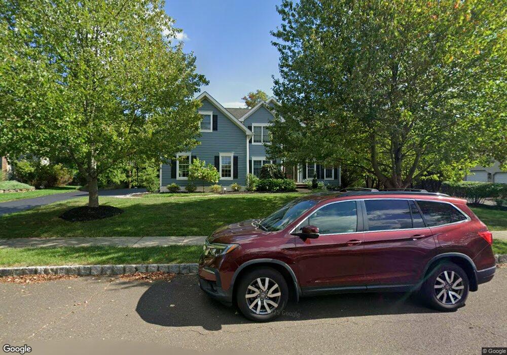
4261 Arbor Ln Doylestown, PA 18902
Estimated Value: $915,000 - $1,194,000
4
Beds
5
Baths
4,829
Sq Ft
$224/Sq Ft
Est. Value
About This Home
This home is located at 4261 Arbor Ln, Doylestown, PA 18902 and is currently estimated at $1,082,879, approximately $224 per square foot. 4261 Arbor Ln is a home located in Bucks County with nearby schools including Cold Spring Elementary School, Holicong Middle School, and Central Bucks High School - East.
Ownership History
Date
Name
Owned For
Owner Type
Purchase Details
Closed on
Feb 13, 2006
Sold by
Cendant Mobility Financial Corp
Bought by
Orrok Peter and Orrok Joyce
Current Estimated Value
Home Financials for this Owner
Home Financials are based on the most recent Mortgage that was taken out on this home.
Original Mortgage
$260,000
Interest Rate
6.8%
Mortgage Type
Purchase Money Mortgage
Purchase Details
Closed on
Oct 22, 2005
Sold by
Magee Bradley E and Magee Sally A
Bought by
Cendant Mobility Financial Corp
Purchase Details
Closed on
Jan 31, 2003
Sold by
Toll Pa Lp
Bought by
Magee Bradley E and Magee Sally A
Home Financials for this Owner
Home Financials are based on the most recent Mortgage that was taken out on this home.
Original Mortgage
$375,000
Interest Rate
5.5%
Mortgage Type
Purchase Money Mortgage
Create a Home Valuation Report for This Property
The Home Valuation Report is an in-depth analysis detailing your home's value as well as a comparison with similar homes in the area
Home Values in the Area
Average Home Value in this Area
Purchase History
| Date | Buyer | Sale Price | Title Company |
|---|---|---|---|
| Orrok Peter | $680,000 | None Available | |
| Cendant Mobility Financial Corp | $720,000 | None Available | |
| Magee Bradley E | $555,731 | -- |
Source: Public Records
Mortgage History
| Date | Status | Borrower | Loan Amount |
|---|---|---|---|
| Previous Owner | Orrok Peter | $260,000 | |
| Previous Owner | Magee Bradley E | $375,000 |
Source: Public Records
Tax History
| Year | Tax Paid | Tax Assessment Tax Assessment Total Assessment is a certain percentage of the fair market value that is determined by local assessors to be the total taxable value of land and additions on the property. | Land | Improvement |
|---|---|---|---|---|
| 2025 | $10,954 | $67,280 | $11,960 | $55,320 |
| 2024 | $10,954 | $67,280 | $11,960 | $55,320 |
| 2023 | $10,582 | $67,280 | $11,960 | $55,320 |
| 2022 | $10,456 | $67,280 | $11,960 | $55,320 |
| 2021 | $10,331 | $67,280 | $11,960 | $55,320 |
| 2020 | $10,331 | $67,280 | $11,960 | $55,320 |
| 2019 | $10,264 | $67,280 | $11,960 | $55,320 |
| 2018 | $10,264 | $67,280 | $11,960 | $55,320 |
| 2017 | $10,179 | $67,280 | $11,960 | $55,320 |
| 2016 | $10,280 | $67,280 | $11,960 | $55,320 |
| 2015 | -- | $67,280 | $11,960 | $55,320 |
| 2014 | -- | $67,280 | $11,960 | $55,320 |
Source: Public Records
Map
Nearby Homes
- 4783 Landisville Rd
- 4179 Miladies Ln
- 4533 Deep Creek Way
- 3960 S Mallard Ln
- 4745 Nottingham Way
- 5087 Raintree Ct
- 4990 Point Pleasant Pike
- 3689 Hancock Ln
- 5182 Point Pleasant Pike
- 6680 Point Pleasant Pike
- 5491 Long Ln
- 5380 Point Pleasant Pike
- 3468 Holicong Rd
- 30 John Dyer Way
- 4215 Ferguson Dr
- 5829 Ridgeview Dr
- 5805 Ridgeview Dr
- 4306 Kleinot Dr
- 4298 Kleinot Dr
- 4330 Kleinot Dr
Your Personal Tour Guide
Ask me questions while you tour the home.