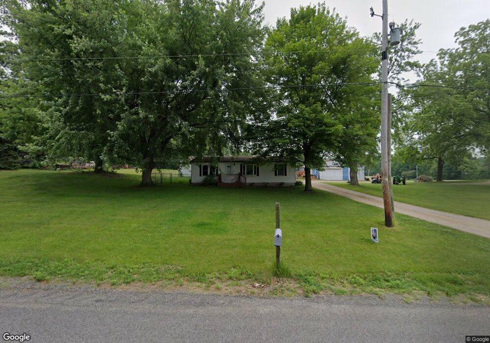
4265 Curran Rd Buchanan, MI 49107
Estimated Value: $79,333 - $306,000
3
Beds
2
Baths
1,080
Sq Ft
$167/Sq Ft
Est. Value
About This Home
This home is located at 4265 Curran Rd, Buchanan, MI 49107 and is currently estimated at $179,833, approximately $166 per square foot. 4265 Curran Rd is a home located in Berrien County with nearby schools including River Valley Middle/High School.
Ownership History
Date
Name
Owned For
Owner Type
Purchase Details
Closed on
Dec 13, 2022
Sold by
Pease Randy R
Bought by
Pease Craig and Pease Angelia N
Current Estimated Value
Purchase Details
Closed on
Jun 14, 2022
Sold by
Jeffrey Pease
Bought by
Pease Craig and Pease Angelia N
Purchase Details
Closed on
Jul 11, 2017
Sold by
Pease Randy R
Bought by
Pease Craig and Pease Angie
Purchase Details
Closed on
Apr 5, 2017
Sold by
Pease Gary
Bought by
Pease Randy
Purchase Details
Closed on
Jul 26, 2016
Sold by
Turner Ruth C and Pease Clayton O
Bought by
Pease Phillip O and Pease Gary
Purchase Details
Closed on
Sep 17, 1996
Purchase Details
Closed on
Aug 26, 1992
Create a Home Valuation Report for This Property
The Home Valuation Report is an in-depth analysis detailing your home's value as well as a comparison with similar homes in the area
Purchase History
| Date | Buyer | Sale Price | Title Company |
|---|---|---|---|
| Pease Craig | $67,117 | -- | |
| Pease Craig | -- | Kotz Sangster Wysocki Pc | |
| Pease Craig | -- | Attorney | |
| Pease Randy | $22,000 | Attorney | |
| Pease Randy | $22,000 | Attorney | |
| Pease Phillip O | -- | Attorney | |
| -- | -- | -- | |
| -- | -- | -- |
Source: Public Records
Tax History
| Year | Tax Paid | Tax Assessment Tax Assessment Total Assessment is a certain percentage of the fair market value that is determined by local assessors to be the total taxable value of land and additions on the property. | Land | Improvement |
|---|---|---|---|---|
| 2025 | $1,142 | $73,100 | $0 | $0 |
| 2024 | $672 | $69,500 | $0 | $0 |
| 2023 | $640 | $59,200 | $0 | $0 |
| 2022 | $610 | $55,300 | $0 | $0 |
| 2021 | $1,062 | $53,400 | $12,000 | $41,400 |
| 2020 | $1,048 | $54,800 | $0 | $0 |
| 2019 | $1,029 | $42,800 | $9,600 | $33,200 |
Source: Public Records
Map
Nearby Homes
- 4935 Curran Rd
- 3410 W Chicago Rd
- 3350 W Bertrand Rd
- 25226 Adams Rd
- 4630 W US Highway 12
- Track 4 W Us 12 Hwy Trail
- 50929 Orange Rd
- 26222 Auten Rd
- W Chicago Rd
- 51691 Windyridge Ct
- 4995 U S 12
- 26252 Woodsong Ct
- 51690 Inverness Dr
- 51265 Enchanted Oak Ct
- 26050 Westwood Hills Dr Unit Lot 42
- 51823 Westwood Forest Dr
- 5011 Bow Line Ct
- 1500 W Bertrand Rd
- 4047 Wildon Ct
- 24222 Adams Rd
Your Personal Tour Guide
Ask me questions while you tour the home.