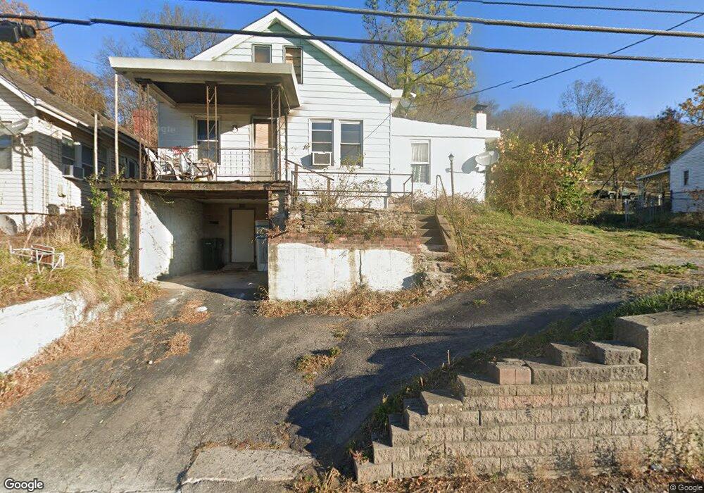
4266 River Rd Cincinnati, OH 45204
Riverside Sedamsville NeighborhoodEstimated Value: $83,000 - $106,000
2
Beds
1
Bath
924
Sq Ft
$97/Sq Ft
Est. Value
About This Home
This home is located at 4266 River Rd, Cincinnati, OH 45204 and is currently estimated at $89,637, approximately $97 per square foot. 4266 River Rd is a home located in Hamilton County with nearby schools including Sayler Park Elementary School, Gilbert A. Dater High School, and Western Hills High School.
Ownership History
Date
Name
Owned For
Owner Type
Purchase Details
Closed on
Apr 20, 2018
Sold by
Bollhauer Mark A and Bollhauer Lisa
Bought by
Norris Pete
Current Estimated Value
Purchase Details
Closed on
May 15, 1999
Sold by
Powell Jerry A and Powell Debbie K
Bought by
Bollhauer Mark A
Home Financials for this Owner
Home Financials are based on the most recent Mortgage that was taken out on this home.
Original Mortgage
$39,990
Interest Rate
6.99%
Create a Home Valuation Report for This Property
The Home Valuation Report is an in-depth analysis detailing your home's value as well as a comparison with similar homes in the area
Home Values in the Area
Average Home Value in this Area
Purchase History
| Date | Buyer | Sale Price | Title Company |
|---|---|---|---|
| Norris Pete | $31,000 | None Available | |
| Bollhauer Mark A | $43,000 | Cambridge Land Title Agency |
Source: Public Records
Mortgage History
| Date | Status | Borrower | Loan Amount |
|---|---|---|---|
| Previous Owner | Bollhauer Mark A | $39,990 |
Source: Public Records
Tax History
| Year | Tax Paid | Tax Assessment Tax Assessment Total Assessment is a certain percentage of the fair market value that is determined by local assessors to be the total taxable value of land and additions on the property. | Land | Improvement |
|---|---|---|---|---|
| 2025 | $844 | $13,129 | $1,883 | $11,246 |
| 2023 | $401 | $6,129 | $1,883 | $4,246 |
| 2022 | $679 | $9,465 | $1,894 | $7,571 |
| 2021 | $663 | $9,465 | $1,894 | $7,571 |
| 2020 | $665 | $9,465 | $1,894 | $7,571 |
| 2019 | $1,011 | $13,157 | $1,722 | $11,435 |
| 2018 | $1,012 | $13,157 | $1,722 | $11,435 |
| 2017 | $974 | $13,157 | $1,722 | $11,435 |
| 2016 | $1,011 | $13,311 | $2,636 | $10,675 |
| 2015 | $905 | $13,311 | $2,636 | $10,675 |
| 2014 | $909 | $13,311 | $2,636 | $10,675 |
| 2013 | $943 | $13,580 | $2,688 | $10,892 |
Source: Public Records
Map
Nearby Homes
- 4904 Riverwatch Dr
- 4186 River Rd
- 298 Kinsman Ct
- 5062 Orangelawn Dr
- 4979 Bonaventure Ct
- 3938 Hillside Ave
- 4231 River Rd Unit Parcel-A
- 4231 River Rd Unit Parcel-C
- 4231 River Rd Unit Parcel-B
- 4231 River Rd Unit Parcel-A-B-C
- 3085 Point Pleasant Rd
- 3908 Pattison Ave
- 2752 River Birch Ln
- 2723 River Birch Dr
- 4938 Mount Alverno Rd
- 2752 River Birch Dr
- 410 Morrvue Dr
- 2672 River Birch Dr
- 3744 Hillside Ave
- 337 Greenwell Ave
- 4268 River Rd
- 4262 River Rd
- 4260 River Rd
- 4280 River Rd
- 4258 River Rd
- 4265 Hillside Ave
- 4254 River Rd
- 4261 Hillside Ave
- 4288 River Rd
- 4248 River Rd
- 4266 Hillside Ave
- 4490 River Rd
- 4294 River Rd
- 4264 Hillside Ave
- 4278 Hillside Ave
- 4232 River Rd
- 4296 River Rd
- 4300 River Rd
- 4288 Hillside Ave
- 4290 Hillside Ave
Your Personal Tour Guide
Ask me questions while you tour the home.