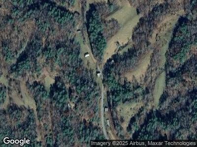
427 Barnes Branch Rd Marshall, NC 28753
Estimated Value: $536,000 - $9,714,000
3
Beds
2
Baths
1,588
Sq Ft
$1,834/Sq Ft
Est. Value
About This Home
This home is located at 427 Barnes Branch Rd, Marshall, NC 28753 and is currently estimated at $2,912,231, approximately $1,833 per square foot. 427 Barnes Branch Rd is a home located in Madison County with nearby schools including Madison Middle School.
Ownership History
Date
Name
Owned For
Owner Type
Purchase Details
Closed on
Aug 16, 2018
Sold by
Seely Kyra W
Bought by
Mazzuca Anthony R
Current Estimated Value
Purchase Details
Closed on
Dec 23, 2011
Sold by
Barringer Bobby A and Mcqueen Kim A
Bought by
Mazzuca Anthony R and Seely Kyra W
Home Financials for this Owner
Home Financials are based on the most recent Mortgage that was taken out on this home.
Original Mortgage
$200,000
Interest Rate
4.07%
Mortgage Type
Unknown
Create a Home Valuation Report for This Property
The Home Valuation Report is an in-depth analysis detailing your home's value as well as a comparison with similar homes in the area
Home Values in the Area
Average Home Value in this Area
Purchase History
| Date | Buyer | Sale Price | Title Company |
|---|---|---|---|
| Mazzuca Anthony R | -- | None Available | |
| Mazzuca Anthony R | $3,755,000 | None Avialable |
Source: Public Records
Mortgage History
| Date | Status | Borrower | Loan Amount |
|---|---|---|---|
| Previous Owner | Mazzuca Anthony R | $200,000 | |
| Previous Owner | Barringer Bobby A | $283,120 |
Source: Public Records
Tax History Compared to Growth
Tax History
| Year | Tax Paid | Tax Assessment Tax Assessment Total Assessment is a certain percentage of the fair market value that is determined by local assessors to be the total taxable value of land and additions on the property. | Land | Improvement |
|---|---|---|---|---|
| 2023 | $1,695 | $391,484 | $161,795 | $229,689 |
| 2022 | $1,695 | $391,484 | $161,795 | $229,689 |
| 2021 | $1,695 | $391,484 | $161,795 | $229,689 |
| 2020 | $1,695 | $391,484 | $161,795 | $229,689 |
| 2019 | $1,965 | $378,374 | $161,783 | $216,591 |
| 2018 | $1,712 | $0 | $0 | $0 |
| 2017 | $1,712 | $0 | $0 | $0 |
| 2016 | $1,712 | $0 | $0 | $0 |
| 2015 | -- | $0 | $0 | $0 |
| 2014 | -- | $378,374 | $161,783 | $216,591 |
| 2013 | -- | $294,578 | $139,487 | $155,091 |
Source: Public Records
Map
Nearby Homes
- 9999 Overlook Ln Unit 24
- 275 Overlook Ln Unit 22
- 276 Overlook Ln Unit 23
- 25 Sunnyside Dr Unit 25
- 9999 Sunnyside Dr Unit 13 & 14
- 936 Sunnyside Dr Unit Lot 27
- 902 Spillcorn Rd
- tbd Joe Tweed Rd
- 00 Culvin Creek Rd
- 00 Duck Mill Rd
- 2252 Cutshall Town Rd
- 16 Caddis Ct
- 1180 Wolf Branch Rd
- 306 Culvin Creek Rd
- 240 Thunderhead Dr
- 124 Wilds Branch Rd
- 1080 Wolf Branch Rd
- Lot 110 Laurel Ridge
- 444 Culvin Creek Rd Unit 145 ACRES
- 000 Bear River Lodge Trail Unit 77
- 427 Barnes Branch Rd
- 00 Barnes Branch Rd
- 228 Barnes Branch Rd
- 150 Barnes Branch Rd
- 152 Barnes Branch Rd
- 120 Barnes Branch Rd
- 2005 Big Laurel Rd
- 1895 Big Laurel Rd
- 0 Wehler Mountain Dr
- 2383 Big Laurel Rd
- 1797 Big Laurel Rd
- 80 Wild Iris Ln Unit 42
- 80 Wild Iris Ln Unit 43, 44
- 80 Wild Iris Ln Unit 45
- TBD 8800 Big Laurel Rd
- 1804 Big Laurel Rd
- 1759 Big Laurel Rd
- 1725 Big Laurel Rd
- 2727 Big Laurel Rd
- 631 Sunnyside Dr Unit 20
