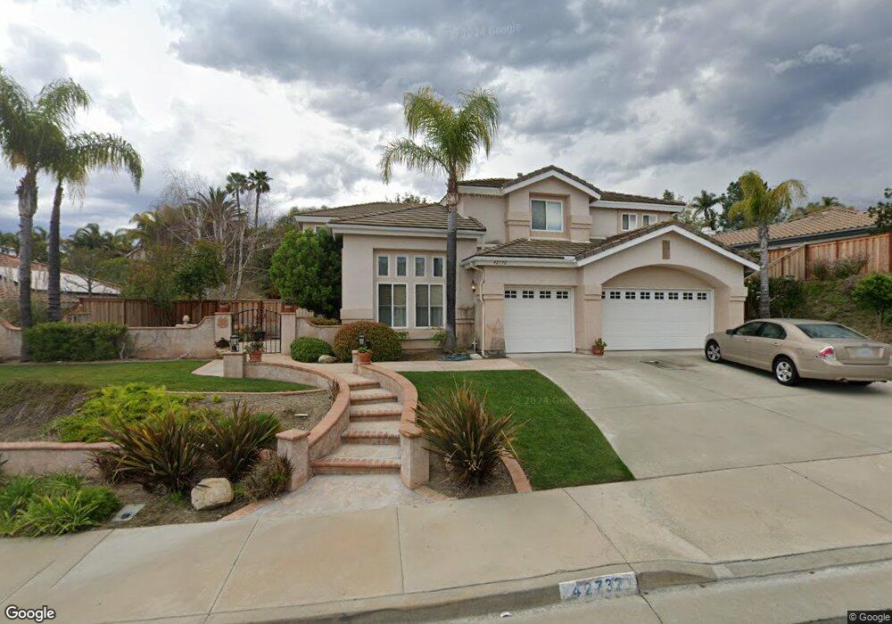
42732 Mountain Shadow Rd Murrieta, CA 92562
Estimated Value: $856,000 - $915,000
5
Beds
3
Baths
3,165
Sq Ft
$280/Sq Ft
Est. Value
About This Home
This home is located at 42732 Mountain Shadow Rd, Murrieta, CA 92562 and is currently estimated at $887,674, approximately $280 per square foot. 42732 Mountain Shadow Rd is a home located in Riverside County with nearby schools including Cole Canyon Elementary School, Thompson Middle School, and Murrieta Valley High School.
Ownership History
Date
Name
Owned For
Owner Type
Purchase Details
Closed on
Jul 20, 2017
Sold by
Anderson David W and Anderson Dale L
Bought by
Anderson Dale L and Anderson David W
Current Estimated Value
Purchase Details
Closed on
Jul 6, 1995
Sold by
L & W Investments Inc
Bought by
Anderson David W and Anderson Dale L
Home Financials for this Owner
Home Financials are based on the most recent Mortgage that was taken out on this home.
Original Mortgage
$114,500
Interest Rate
7.47%
Mortgage Type
Purchase Money Mortgage
Create a Home Valuation Report for This Property
The Home Valuation Report is an in-depth analysis detailing your home's value as well as a comparison with similar homes in the area
Purchase History
We collect this data history from publicly available records. To have your information removed, we recommend requesting removal directly through your county’s website.
| Date | Buyer | Sale Price | Title Company |
|---|---|---|---|
| Anderson Dale L | -- | None Available | |
| Anderson David W | $203,000 | Continental Lawyers Title Co |
Source: Public Records
Mortgage History
We collect this data history from publicly available records. To have your information removed, we recommend requesting removal directly through your county’s website.
| Date | Status | Borrower | Loan Amount |
|---|---|---|---|
| Previous Owner | Anderson David W | $114,500 |
Source: Public Records
Tax History
| Year | Tax Paid | Tax Assessment Tax Assessment Total Assessment is a certain percentage of the fair market value that is determined by local assessors to be the total taxable value of land and additions on the property. | Land | Improvement |
|---|---|---|---|---|
| 2025 | $4,726 | $368,142 | $66,424 | $301,718 |
| 2023 | $4,726 | $353,848 | $63,846 | $290,002 |
| 2022 | $4,696 | $346,911 | $62,595 | $284,316 |
| 2021 | $4,613 | $340,110 | $61,368 | $278,742 |
| 2020 | $4,570 | $336,623 | $60,739 | $275,884 |
| 2019 | $4,489 | $330,024 | $59,549 | $270,475 |
| 2018 | $4,409 | $323,554 | $58,383 | $265,171 |
| 2017 | $4,351 | $317,211 | $57,239 | $259,972 |
| 2016 | $4,296 | $310,992 | $56,117 | $254,875 |
| 2015 | $4,253 | $306,323 | $55,275 | $251,048 |
| 2014 | $4,078 | $300,325 | $54,194 | $246,131 |
Source: Public Records
Map
Nearby Homes
- 23476 Bending Oak Ct
- 23046 Joaquin Ridge Dr
- 37701 Oxford Dr
- 37672 Oxford Dr
- 37258 Huckaby Ln
- 37211 Jerome Ln
- 37168 Santa Rosa Glen Dr
- 37528 Windsor Ct
- 23553 Bending Oak Ct
- 23450 Bristol Way
- 38027 Cherrywood Dr
- 0 Rancho Mirlo Rd Unit IV25186834
- 23250 Rancho Mirlo Rd
- 22862 Montanya Place
- 38521 Glen Abbey Ln
- 38124 Placer Creek St
- 38574 Lochinvar Ct
- 38220 Calle Cipres
- 23710 Pepperleaf St
- 23831 Cloverleaf Way
- 42728 Mountain Shadow Rd
- 42740 Mountain Shadow Rd
- 42741 Settlers Ridge
- 42745 Settlers Ridge
- 42724 Mountain Shadow Rd
- 42744 Mountain Shadow Rd
- 42735 Mountain Shadow Rd
- 42731 Mountain Shadow Rd
- 42737 Settlers Ridge
- 42739 Mountain Shadow Rd
- 42749 Settlers Ridge
- 42727 Mountain Shadow Rd
- 42720 Mountain Shadow Rd
- 42748 Mountain Shadow Rd
- 42743 Mountain Shadow Rd
- 42723 Mountain Shadow Rd
- 42733 Settlers Ridge
- 42753 Settlers Ridge
- 42747 Mountain Shadow Rd
- 42716 Mountain Shadow Rd
Your Personal Tour Guide
Ask me questions while you tour the home.