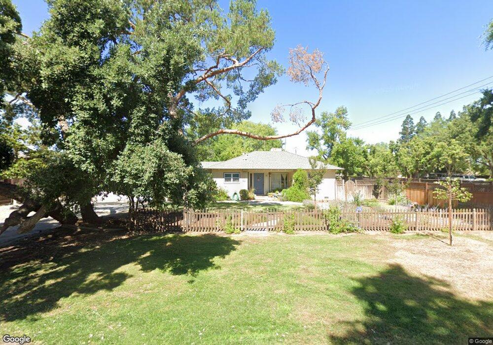
4287 N Arthur Ave Fresno, CA 93705
Bullard NeighborhoodEstimated Value: $362,000 - $464,000
3
Beds
2
Baths
1,555
Sq Ft
$268/Sq Ft
Est. Value
About This Home
This home is located at 4287 N Arthur Ave, Fresno, CA 93705 and is currently estimated at $416,661, approximately $267 per square foot. 4287 N Arthur Ave is a home located in Fresno County with nearby schools including Powers-Ginsburg Elementary, Bullard High School, and Aspen Valley Prep Academy.
Ownership History
Date
Name
Owned For
Owner Type
Purchase Details
Closed on
Apr 5, 2007
Sold by
Shaver Benjamin C and Shaver Karen R
Bought by
Shaver Benjamin C and Shaver Karen R
Current Estimated Value
Create a Home Valuation Report for This Property
The Home Valuation Report is an in-depth analysis detailing your home's value as well as a comparison with similar homes in the area
Home Values in the Area
Average Home Value in this Area
Purchase History
| Date | Buyer | Sale Price | Title Company |
|---|---|---|---|
| Shaver Benjamin C | -- | None Available |
Source: Public Records
Tax History Compared to Growth
Tax History
| Year | Tax Paid | Tax Assessment Tax Assessment Total Assessment is a certain percentage of the fair market value that is determined by local assessors to be the total taxable value of land and additions on the property. | Land | Improvement |
|---|---|---|---|---|
| 2025 | $2,712 | $229,044 | $54,095 | $174,949 |
| 2023 | $2,658 | $220,152 | $51,996 | $168,156 |
| 2022 | $2,621 | $215,836 | $50,977 | $164,859 |
| 2021 | $2,547 | $211,605 | $49,978 | $161,627 |
| 2020 | $2,535 | $209,436 | $49,466 | $159,970 |
| 2019 | $2,435 | $205,331 | $48,497 | $156,834 |
| 2018 | $2,380 | $201,306 | $47,547 | $153,759 |
| 2017 | $2,338 | $197,360 | $46,615 | $150,745 |
| 2016 | $2,258 | $193,491 | $45,701 | $147,790 |
| 2015 | $2,223 | $190,586 | $45,015 | $145,571 |
| 2014 | $2,178 | $186,854 | $44,134 | $142,720 |
Source: Public Records
Map
Nearby Homes
- 4246 N Holt Ave
- 4264 N Holt Ave
- 4261 N Holt Ave
- 82 E Sussex Way
- 1028 W Holland Ave
- 94 E Sussex Way
- 4481 N Palm Ave
- 929 W Norwich Ave
- 4366 N Holt Ave
- 1027 W Ashcroft Ave
- 4702 N Fruit Ave
- 4480 N Palm Ave
- 638 W Rialto Ave
- 4666 N Harrison Ave
- 3932 N Safford Ave
- 336 E Gettysburg Ave
- 4306 N Emerson Ave
- B N Fruit Ave
- 4175 N Van Ness Blvd
- 4734 N Harrison Ave
- 4261 N Arthur Ave
- 331 W Swift Ave
- 300 W Swift Ave
- 4290 N Arthur Ave
- 4251 N Arthur Ave
- 4268 N Arthur Ave
- 330 W Swift Ave
- 246 W Swift Ave
- 4254 N Arthur Ave
- 415 W Swift Ave
- 4333 N Arthur Ave
- 410 W Swift Ave
- 223 W Swift Ave
- 4332 N Arthur Ave
- 4239 N Arthur Ave
- 180 W Swift Ave
- 4244 N Fruit Ave
- 447 W Swift Ave
- 4219 N Arthur Ave
- 4230 N Arthur Ave