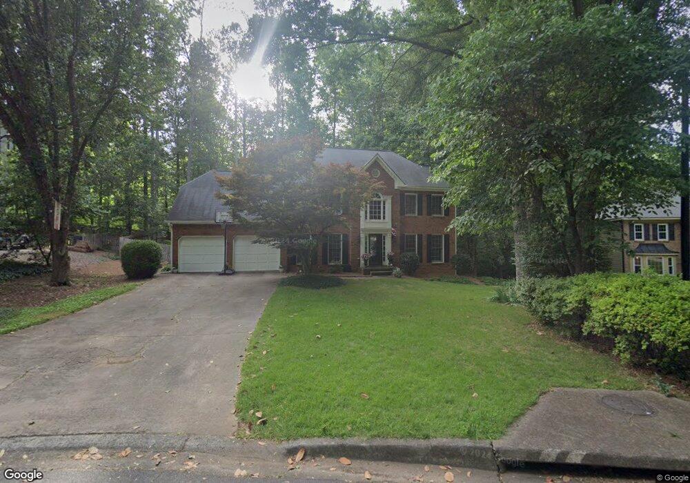
4287 Parish Trace Marietta, GA 30066
Sandy Plains NeighborhoodEstimated Value: $726,000 - $886,000
5
Beds
3
Baths
3,587
Sq Ft
$228/Sq Ft
Est. Value
About This Home
This home is located at 4287 Parish Trace, Marietta, GA 30066 and is currently estimated at $817,015, approximately $227 per square foot. 4287 Parish Trace is a home located in Cobb County with nearby schools including Davis Elementary School, Mabry Middle School, and Lassiter High School.
Ownership History
Date
Name
Owned For
Owner Type
Purchase Details
Closed on
Jun 22, 2010
Sold by
Benedetto Roberto O and Benedetto Maria A
Bought by
Brophy John D and Brophy Nancy C
Current Estimated Value
Home Financials for this Owner
Home Financials are based on the most recent Mortgage that was taken out on this home.
Original Mortgage
$354,040
Outstanding Balance
$234,703
Interest Rate
4.75%
Mortgage Type
FHA
Estimated Equity
$582,312
Purchase Details
Closed on
Jun 7, 1997
Sold by
Crotty James M and Crotty Georgian
Bought by
Lyons Boyd K
Home Financials for this Owner
Home Financials are based on the most recent Mortgage that was taken out on this home.
Original Mortgage
$218,250
Interest Rate
7.3%
Mortgage Type
New Conventional
Create a Home Valuation Report for This Property
The Home Valuation Report is an in-depth analysis detailing your home's value as well as a comparison with similar homes in the area
Home Values in the Area
Average Home Value in this Area
Purchase History
| Date | Buyer | Sale Price | Title Company |
|---|---|---|---|
| Brophy John D | $360,000 | -- | |
| Lyons Boyd K | $242,500 | -- |
Source: Public Records
Mortgage History
| Date | Status | Borrower | Loan Amount |
|---|---|---|---|
| Open | Brophy John D | $354,040 | |
| Previous Owner | Lyons Boyd K | $218,250 |
Source: Public Records
Tax History Compared to Growth
Tax History
| Year | Tax Paid | Tax Assessment Tax Assessment Total Assessment is a certain percentage of the fair market value that is determined by local assessors to be the total taxable value of land and additions on the property. | Land | Improvement |
|---|---|---|---|---|
| 2025 | $6,181 | $247,064 | $64,000 | $183,064 |
| 2024 | $6,186 | $247,064 | $64,000 | $183,064 |
| 2023 | $5,637 | $246,772 | $50,000 | $196,772 |
| 2022 | $5,163 | $198,144 | $44,000 | $154,144 |
| 2021 | $4,614 | $173,068 | $40,800 | $132,268 |
| 2020 | $4,614 | $173,068 | $40,800 | $132,268 |
| 2019 | $4,312 | $159,256 | $38,000 | $121,256 |
| 2018 | $4,312 | $159,256 | $38,000 | $121,256 |
| 2017 | $4,124 | $159,256 | $38,000 | $121,256 |
| 2016 | $3,952 | $151,296 | $36,000 | $115,296 |
| 2015 | $4,045 | $151,296 | $36,000 | $115,296 |
| 2014 | $3,597 | $129,916 | $0 | $0 |
Source: Public Records
Map
Nearby Homes
- 4259 Arbor Club Dr
- 2713 Arbor Summit
- 2696 S Arbor Dr
- 3901 Hazelhurst Dr
- 3043 Sawyer Trace NE
- 4464 Windsor Oaks Dr
- 3798 Upland Dr
- 3130 Maley Ct
- 4397 Windsor Oaks Cir
- 2855 Lamer Trace
- 3333 Devaughn Dr NE
- 2578 Middle Coray Cir
- 4563 Ashmore Cir NE
- 3147 Swallow Dr NE
- 3350 Brookhill Cir
- 2402 Woodbridge Dr
- 3238 Mountain Hollow Dr
- 2610 Chadwick Rd
- 2842 Forest Chase Dr NE
- 4289 Parish Trace Unit 7
- 4289 Parish Trace NE
- 4285 Parish Trace
- 4291 Parish Trace
- 4283 Parish Trace
- 4294 Parish Trace
- 2868 Liberty Ct Unit 6
- 4100 Indian Town Rd
- 4293 Parish Trace
- 4284 Parish Trace
- 4286 Parish Trace Unit 7
- 2870 Liberty Ct Unit 6
- 2869 Liberty Ct Unit 6
- 4187 Liberty Trace
- 4185 Liberty Trace
- 4300 Parish Trace
- 4171 Liberty Trace
- 4163 Liberty Trace
- 4297 Parish Trace
- 4076 Indian Town Rd