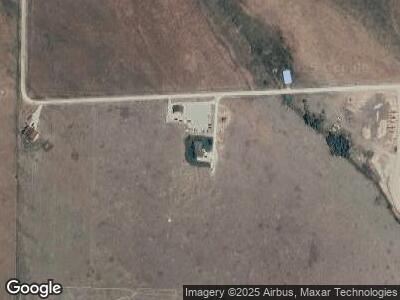
4295 W 10750 N Tetonia, ID 83424
Estimated Value: $1,050,000
6
Beds
3
Baths
3,858
Sq Ft
$272/Sq Ft
Est. Value
About This Home
This home is located at 4295 W 10750 N, Tetonia, ID 83424 and is currently estimated at $1,050,000, approximately $272 per square foot. 4295 W 10750 N is a home located in Teton County with nearby schools including Teton High School.
Ownership History
Date
Name
Owned For
Owner Type
Purchase Details
Closed on
Nov 21, 2024
Sold by
Gbd Property Development Llc
Bought by
Vanleerdam Tammera
Current Estimated Value
Purchase Details
Closed on
Aug 20, 2024
Sold by
Erwin Nic and Erwin Nicholas
Bought by
Gbd Property Development Llc
Purchase Details
Closed on
Apr 5, 2021
Sold by
Huff Jeremy M and Huff Denise A
Bought by
Teewinot Holdings Llc
Purchase Details
Closed on
Nov 6, 2006
Sold by
Arnold Dennie K and Arnold Janet
Bought by
Huff Jeremy M and Huff Denise A
Create a Home Valuation Report for This Property
The Home Valuation Report is an in-depth analysis detailing your home's value as well as a comparison with similar homes in the area
Home Values in the Area
Average Home Value in this Area
Purchase History
| Date | Buyer | Sale Price | Title Company |
|---|---|---|---|
| Vanleerdam Tammera | -- | Alliance Title | |
| Vanleerdam Tammera | -- | Alliance Title | |
| Gbd Property Development Llc | -- | Alliance Title | |
| Teewinot Holdings Llc | -- | First American Title Driggs | |
| Huff Jeremy M | -- | -- |
Source: Public Records
Mortgage History
| Date | Status | Borrower | Loan Amount |
|---|---|---|---|
| Previous Owner | Teewinot Holdings Llc | $732,100 | |
| Previous Owner | Huff Jeremy M | $290,000 |
Source: Public Records
Tax History Compared to Growth
Tax History
| Year | Tax Paid | Tax Assessment Tax Assessment Total Assessment is a certain percentage of the fair market value that is determined by local assessors to be the total taxable value of land and additions on the property. | Land | Improvement |
|---|---|---|---|---|
| 2024 | $4,071 | $1,159,880 | $240,120 | $919,760 |
| 2023 | $4,071 | $1,159,880 | $240,120 | $919,760 |
| 2022 | $4,052 | $960,225 | $150,742 | $809,483 |
| 2021 | $3,977 | $580,705 | $112,056 | $468,649 |
| 2020 | $3,102 | $464,599 | $80,040 | $384,559 |
| 2019 | $3,017 | $464,599 | $80,040 | $384,559 |
| 2018 | $2,932 | $426,577 | $73,370 | $353,207 |
| 2017 | $2,663 | $426,577 | $73,370 | $353,207 |
| 2016 | $2,566 | $387,219 | $66,700 | $320,519 |
| 2015 | $2,461 | $331,551 | $53,360 | $278,191 |
| 2011 | -- | $353,581 | $70,035 | $283,546 |
Source: Public Records
Map
Nearby Homes
- 10223 N End Trail
- 4428 W 9700 N
- 4120 W 9500 N
- 3097 Reece Ridge Rd
- 8779 Grizzly Ridge Rd
- 2633 Spring Hollow Ranch Rd
- 9620 Mountain View Dr
- 3114 Sky View Dr
- 9578 Buck Town Blvd
- 9654 Buck Town Blvd
- 7666 Spirit Horse Trail
- 7365 Summer Breeze Trail
- 7000 N 3500 W
- 9495 River Rim Ranch Rd Unit 7
- 0 River Rim Ranch Rd Unit 25-803
- 9505 Upper Ranch Ln
- 9455 Upper Ranch Ln
- 3 LOTS Upper Ranch Ln
- 219 Moonlight Ln
- 9415 Upper Ranch Ln
