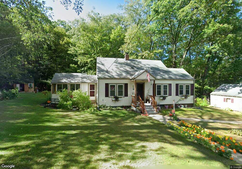
43 Birches Rd Hubbardston, MA 01452
Estimated Value: $354,000 - $397,433
1
Bed
1
Bath
884
Sq Ft
$431/Sq Ft
Est. Value
About This Home
This home is located at 43 Birches Rd, Hubbardston, MA 01452 and is currently estimated at $381,144, approximately $431 per square foot. 43 Birches Rd is a home located in Worcester County with nearby schools including Quabbin Regional Middle School and Quabbin Regional High School.
Ownership History
Date
Name
Owned For
Owner Type
Purchase Details
Closed on
Dec 14, 2016
Sold by
Suchocki Stanley J and Suchocki Elizabeth A
Bought by
Suchocki Livinh T
Current Estimated Value
Purchase Details
Closed on
Aug 25, 2016
Sold by
Suchocki Lt
Bought by
Suchocki Stanley J and Suchocki Elizabeth A
Purchase Details
Closed on
Apr 14, 2010
Sold by
Suchocki Stanley J and Suchocki Elizabeth A
Bought by
Suchocki Jr Tr Stanley J and Suchocki Elizabeth A
Create a Home Valuation Report for This Property
The Home Valuation Report is an in-depth analysis detailing your home's value as well as a comparison with similar homes in the area
Home Values in the Area
Average Home Value in this Area
Purchase History
| Date | Buyer | Sale Price | Title Company |
|---|---|---|---|
| Suchocki Livinh T | -- | -- | |
| Suchocki Stanley J | -- | -- | |
| Suchocki Jr Tr Stanley J | -- | -- |
Source: Public Records
Tax History Compared to Growth
Tax History
| Year | Tax Paid | Tax Assessment Tax Assessment Total Assessment is a certain percentage of the fair market value that is determined by local assessors to be the total taxable value of land and additions on the property. | Land | Improvement |
|---|---|---|---|---|
| 2025 | $3,610 | $309,100 | $113,200 | $195,900 |
| 2024 | $3,319 | $281,500 | $99,300 | $182,200 |
| 2023 | $3,182 | $244,200 | $93,700 | $150,500 |
| 2022 | $3,419 | $244,200 | $93,700 | $150,500 |
| 2021 | $3,197 | $215,900 | $93,700 | $122,200 |
| 2020 | $3,167 | $213,700 | $93,700 | $120,000 |
| 2019 | $3,192 | $209,700 | $108,100 | $101,600 |
| 2018 | $3,783 | $203,000 | $108,100 | $94,900 |
| 2017 | $333 | $203,000 | $108,100 | $94,900 |
| 2016 | $7,064 | $192,600 | $108,100 | $84,500 |
Source: Public Records
Map
Nearby Homes
- 23 Geordie Ln
- 3 Gary Rd
- 4 Pitcherville Rd
- 7 1st St
- 171 South Rd
- 106 Gardner Rd
- 72 Cottage Ln Unit (B)
- 72 Cottage Ln Unit (A)
- 87 Hubbardston Rd
- 747 Timpany Blvd
- 23 Schoolhouse Rd
- 18 S Main St
- 104 Patriots Rd
- 14 Baker Ln
- 0 Gardner Rd Unit Willow
- 0 Gardner Rd Unit Applewood
- 133 Patriots Rd
- 89 Patriots Rd
- 283 Mill St
- 620 Whitney St
- 42 Birches Rd
- 40 Birches Rd
- Lot 6 S Main St
- 146 Ragged Hill Rd
- 511 S Main St
- 50 Birches Rd
- 142 Ragged Hill Rd
- 140 Ragged Hill Rd
- 52 Birches Rd
- 138 Ragged Hill Rd
- 0 Birches Rd
- 1A Birches Rd
- 1B Birches Rd
- 149 Ragged Hill Rd
- 56 Birches Rd
- 24 Birches Rd
- 134 Ragged Hill Rd
- 67 Pitcherville Rd
- 4 Byrne Dr
- 2 Byrne Dr