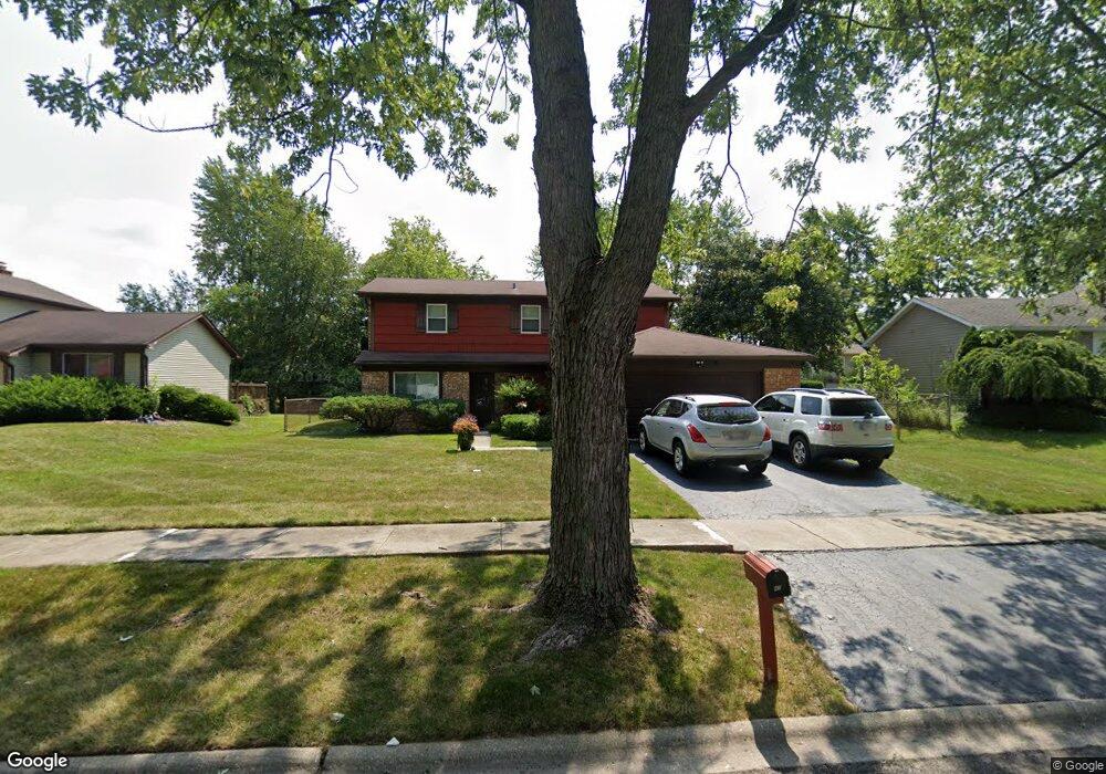
43 Huntingwood Rd Matteson, IL 60443
West Matteson NeighborhoodEstimated Value: $281,000 - $320,000
4
Beds
3
Baths
1,917
Sq Ft
$152/Sq Ft
Est. Value
About This Home
This home is located at 43 Huntingwood Rd, Matteson, IL 60443 and is currently estimated at $292,340, approximately $152 per square foot. 43 Huntingwood Rd is a home located in Cook County with nearby schools including Colin Powell Middle School.
Ownership History
Date
Name
Owned For
Owner Type
Purchase Details
Closed on
Sep 24, 2018
Sold by
Bryant Catherine V
Bought by
Bryant Catherine V and The Catherine V Bryant Trust
Current Estimated Value
Purchase Details
Closed on
Mar 1, 2001
Sold by
Bryant Catherine V
Bought by
Bryant David S and Bryant Catherine V
Create a Home Valuation Report for This Property
The Home Valuation Report is an in-depth analysis detailing your home's value as well as a comparison with similar homes in the area
Home Values in the Area
Average Home Value in this Area
Purchase History
| Date | Buyer | Sale Price | Title Company |
|---|---|---|---|
| Bryant Catherine V | -- | Attorney | |
| Bryant David S | -- | -- |
Source: Public Records
Tax History Compared to Growth
Tax History
| Year | Tax Paid | Tax Assessment Tax Assessment Total Assessment is a certain percentage of the fair market value that is determined by local assessors to be the total taxable value of land and additions on the property. | Land | Improvement |
|---|---|---|---|---|
| 2024 | $6,646 | $22,000 | $3,715 | $18,285 |
| 2023 | $3,009 | $22,000 | $3,715 | $18,285 |
| 2022 | $3,009 | $15,789 | $3,251 | $12,538 |
| 2021 | $2,957 | $15,787 | $3,250 | $12,537 |
| 2020 | $2,662 | $15,787 | $3,250 | $12,537 |
| 2019 | $3,079 | $14,842 | $3,018 | $11,824 |
| 2018 | $3,039 | $14,842 | $3,018 | $11,824 |
| 2017 | $4,590 | $14,842 | $3,018 | $11,824 |
| 2016 | $4,141 | $12,903 | $2,786 | $10,117 |
| 2015 | $4,272 | $12,903 | $2,786 | $10,117 |
| 2014 | $4,202 | $12,903 | $2,786 | $10,117 |
| 2013 | $4,513 | $14,318 | $2,786 | $11,532 |
Source: Public Records
Map
Nearby Homes
- 111 Deerpath Rd
- 116 Cloverleaf Rd
- 50 Oakhurst Rd
- 5911 Timberlane Rd
- 25 Pheasant Rd
- 13 Oakview Rd
- 5838 Woodgate Dr
- 123 Oriole Rd
- 5628 Crestwood Rd
- 42 Pheasant Rd
- 5629 Crestwood Rd
- 5808 Allemong Dr
- 217 Oriole Rd
- 50 Willow Rd
- 10 Wedgewood Rd
- 255 Central Ave
- 322 Central Ave
- 6021 Spring Ln
- 6037 Spring Ln
- 340 Maryview Ct