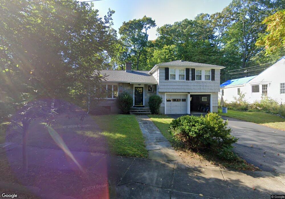
43 Lawmarissa Rd Waban, MA 02468
Waban NeighborhoodEstimated Value: $1,502,000 - $1,821,000
3
Beds
3
Baths
1,782
Sq Ft
$935/Sq Ft
Est. Value
About This Home
This home is located at 43 Lawmarissa Rd, Waban, MA 02468 and is currently estimated at $1,666,937, approximately $935 per square foot. 43 Lawmarissa Rd is a home located in Middlesex County with nearby schools including Angier Elementary School, Charles E Brown Middle School, and Newton South High School.
Ownership History
Date
Name
Owned For
Owner Type
Purchase Details
Closed on
Jul 16, 1996
Sold by
Pollock Anita F
Bought by
Pollock Jeffrey F and Pollock Allison B
Current Estimated Value
Home Financials for this Owner
Home Financials are based on the most recent Mortgage that was taken out on this home.
Original Mortgage
$207,000
Interest Rate
7.98%
Mortgage Type
Purchase Money Mortgage
Create a Home Valuation Report for This Property
The Home Valuation Report is an in-depth analysis detailing your home's value as well as a comparison with similar homes in the area
Home Values in the Area
Average Home Value in this Area
Purchase History
| Date | Buyer | Sale Price | Title Company |
|---|---|---|---|
| Pollock Jeffrey F | $375,000 | -- |
Source: Public Records
Mortgage History
| Date | Status | Borrower | Loan Amount |
|---|---|---|---|
| Open | Pollock Jeffrey F | $180,000 | |
| Closed | Pollock Jeffrey F | $195,000 | |
| Closed | Pollock Jeffrey F | $207,000 | |
| Closed | Pollock Jeffrey F | $43,000 |
Source: Public Records
Tax History Compared to Growth
Tax History
| Year | Tax Paid | Tax Assessment Tax Assessment Total Assessment is a certain percentage of the fair market value that is determined by local assessors to be the total taxable value of land and additions on the property. | Land | Improvement |
|---|---|---|---|---|
| 2025 | $13,247 | $1,351,700 | $1,247,900 | $103,800 |
| 2024 | $12,808 | $1,312,300 | $1,211,600 | $100,700 |
| 2023 | $11,970 | $1,175,800 | $934,600 | $241,200 |
| 2022 | $11,453 | $1,088,700 | $865,400 | $223,300 |
| 2021 | $11,052 | $1,027,100 | $816,400 | $210,700 |
| 2020 | $10,723 | $1,027,100 | $816,400 | $210,700 |
| 2019 | $10,421 | $997,200 | $792,600 | $204,600 |
| 2018 | $10,012 | $925,300 | $719,800 | $205,500 |
| 2017 | $9,707 | $872,900 | $679,100 | $193,800 |
| 2016 | $9,284 | $815,800 | $634,700 | $181,100 |
| 2015 | $8,851 | $762,400 | $593,200 | $169,200 |
Source: Public Records
Map
Nearby Homes
- 29 Montclair Rd
- 115 Windsor Rd
- 1430 Beacon St
- 80 Pine Ridge Rd
- 20 Kinmonth Rd Unit 203
- 20 Kinmonth Rd Unit 306
- 25 Allen Ave
- 18 Annawan Rd
- 1801 Beacon St
- 33 Metacomet Rd
- 10 Ruane Rd
- 1640 Commonwealth Ave
- 34 Pilgrim Rd
- 308 Prince St
- 10 Lorraine Cir
- 131 Oliver Rd
- 39 Valentine Park
- 120 Stanley Rd
- 35 Kingston Rd
- 873 Chestnut St