43 N Enston Ave Charleston, SC 29403
North Central NeighborhoodEstimated payment $5,381/month
Highlights
- Spa
- Community Spa
- Front Porch
- Game Room
- Converted Garage
- Slate Flooring
About This Home
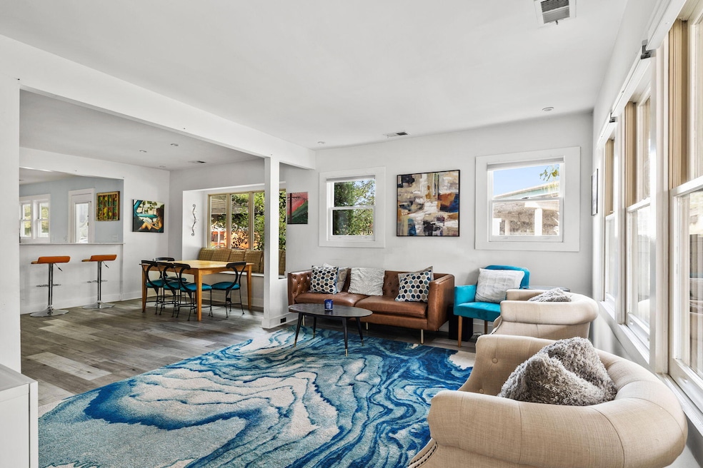
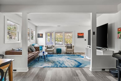
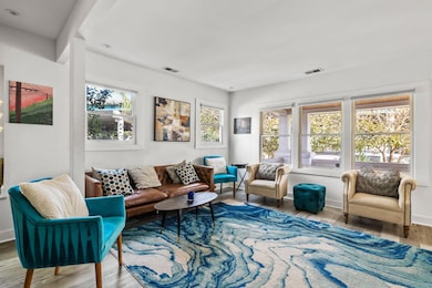
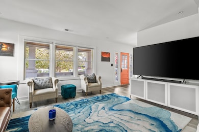
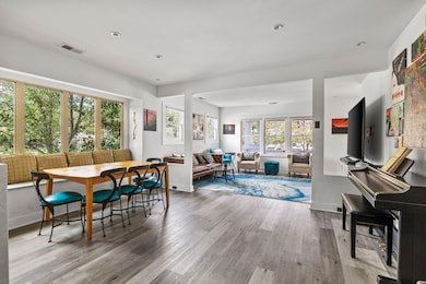
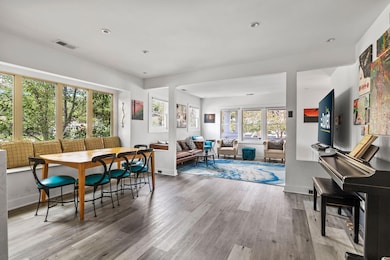
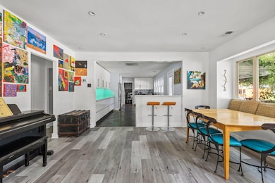
A truly one-of-a-kind downtown retreat! This re-imagined 5-bed, 2.5-bath home blends its Sears Roebuck ''Hazelton'' heritage with striking modern design. Nearly 2,000 sq ft of open living space and 600+ sq ft of Ipe-accented decking flow seamlessly into the established garden areas, offering a rare balance of creativity and calm in the city. Inside, clean lines meet functional luxury. The chef's kitchen centers around a quartz waterfall peninsula, 48'' dual-fuel range, and custom high-gloss cabinetry with integrated drawer systems and a built-in wine cooler. Stainless appliances, an under-counter microwave, and frameless foil-wrapped finishes complete a look that's both modern and timeless. The open layout connects kitchen, living, and deck for effortless entertaining.Step outside to enjoy three distinct deck spaces totaling over 600 sq ft. A jasmine-draped rear deck with 10-person saltwater spa. A cozy front porch framed by tropical gardens.A private side deck perfect for coffee or quiet reading.The landscaping features mature palms, cherry, camphor, and peach trees, all framed by decorative fencing with Ipe toppers and privacy panels. Discreet storage encloses bikes, kayaks, and garden tools, keeping the aesthetic pristine. Smart lighting both interior and exterior sets the perfect mood from sunrise to midnight. With three private entrances (front, rear, and side), the home's layout easily supports a guest suite or rental potential. Each entry offers a sense of privacy and flow, giving the property flexibility rarely found downtown. Metal roof (2021). Encapsulated crawl space with dehumidifier.Two mini-splits added in 2023 to complement central HVAC. Additional electrical sub-panel.Updated plumbing and slate tile bathroom.Two off-street parking spaces, a downtown luxury! Positioned across from Container Bar and moments from the upcoming Low Line, this home is recognized for its bold design and creative spirit, an admired fixture in one of Charleston's most dynamic neighborhoods. Whether you're hosting dinner under jasmine-scented string lights, cooking with friends, or sipping coffee in the garden, this home embodies the rare combination of character, craftsmanship, and contemporary ease.
Seller is a licensed South Carolina real estate agent.

Home Details
Home Type
- Single Family
Est. Annual Taxes
- $1,389
Year Built
- Built in 1929
Lot Details
- 4,792 Sq Ft Lot
- Wood Fence
Home Design
- Architectural Shingle Roof
- Asphalt Roof
- Metal Roof
- Cement Siding
Interior Spaces
- 1,920 Sq Ft Home
- 1-Story Property
- Combination Dining and Living Room
- Game Room
- Crawl Space
- Stacked Washer and Dryer
Kitchen
- Electric Oven
- Gas Cooktop
- Microwave
- Dishwasher
- ENERGY STAR Qualified Appliances
Flooring
- Slate Flooring
- Luxury Vinyl Plank Tile
Bedrooms and Bathrooms
- 5 Bedrooms
Parking
- Converted Garage
- Off-Street Parking
Outdoor Features
- Spa
- Outdoor Storage
- Front Porch
Location
- Property is near a bus stop
Schools
- James Simons Elementary School
- West Ashley Middle School
- Burke High School
Utilities
- Central Heating and Cooling System
- Heating System Mounted To A Wall or Window
Community Details
Overview
- North Central Subdivision
Recreation
- Community Spa
Map
Home Values in the Area
Average Home Value in this Area
Tax History
| Year | Tax Paid | Tax Assessment Tax Assessment Total Assessment is a certain percentage of the fair market value that is determined by local assessors to be the total taxable value of land and additions on the property. | Land | Improvement |
|---|---|---|---|---|
| 2024 | $1,389 | $8,400 | $0 | $0 |
| 2023 | $1,186 | $8,400 | $0 | $0 |
| 2022 | $1,083 | $8,400 | $0 | $0 |
| 2021 | $1,133 | $8,400 | $0 | $0 |
| 2020 | $1,173 | $8,400 | $0 | $0 |
| 2019 | $1,050 | $7,310 | $0 | $0 |
| 2017 | $993 | $7,130 | $0 | $0 |
| 2016 | $954 | $7,130 | $0 | $0 |
| 2015 | $984 | $7,130 | $0 | $0 |
| 2014 | $850 | $0 | $0 | $0 |
| 2011 | -- | $0 | $0 | $0 |
Property History
| Date | Event | Price | List to Sale | Price per Sq Ft |
|---|---|---|---|---|
| 11/28/2025 11/28/25 | Price Changed | $999,999 | -4.7% | $521 / Sq Ft |
| 11/21/2025 11/21/25 | Price Changed | $1,049,000 | -4.5% | $546 / Sq Ft |
| 11/12/2025 11/12/25 | Price Changed | $1,099,000 | -4.4% | $572 / Sq Ft |
| 10/17/2025 10/17/25 | Price Changed | $1,149,000 | -4.2% | $598 / Sq Ft |
| 10/06/2025 10/06/25 | For Sale | $1,199,000 | -- | $624 / Sq Ft |
Purchase History
| Date | Type | Sale Price | Title Company |
|---|---|---|---|
| Deed | $145,000 | None Available |
Mortgage History
| Date | Status | Loan Amount | Loan Type |
|---|---|---|---|
| Open | $29,000 | Stand Alone Second | |
| Open | $116,000 | Balloon |
Source: CHS Regional MLS
MLS Number: 25027132
APN: 463-08-01-001
Disclaimer: Certain information contained herein is derived from information provided by parties other than Homes.com. All information provided is deemed reliable, but is not guaranteed to be accurate and should be independently verified.
![]() The information is being provided by Charleston Trident MLS. Information deemed reliable but not guaranteed. Information is provided for consumers' personal, non-commercial use, and may not be used for any purpose other than the identification of potential properties for purchase. © 2025 Charleston Trident MLS. All Rights Reserved
The information is being provided by Charleston Trident MLS. Information deemed reliable but not guaranteed. Information is provided for consumers' personal, non-commercial use, and may not be used for any purpose other than the identification of potential properties for purchase. © 2025 Charleston Trident MLS. All Rights Reserved
- 35 N Enston Ave
- 928 Rutledge Ave
- 2130 Weaver St
- 924 Rutledge Ave
- 923 Rutledge Ave
- 1328 Cottonwood St
- 1011 Ashley Ave
- 75 Cypress St
- 78 Maple St
- 1122 King St
- 4 Poplar St
- 829 Rutledge Ave
- 8 Simons St
- 814 Rutledge Ave
- 65 Simons St
- 4 Piedmont Ave
- 874 Ashley Ave
- 2 Bedroom D Plan at Ocean Pines
- 2 Bedroom E Plan at Ocean Pines
- 3 Bedroom C Plan at Ocean Pines
- 1405 Holt St
- 1310 Meeting Street Rd
- 10 Riker St
- 695 Meeting St
- 102 Sottile St
- 55 Romney St
- 651 Meeting St
- 20 Romney St
- 1 Cool Blow St Unit 326
- 1000 King St
- 601 Meeting St
- 601 Meeting St Unit Woodburn
- 601 Meeting St Unit Tobin
- 601 Meeting St Unit Ben Sawyer
- 287 Huger St
- 4 Senate St
- 577 Meeting St
- 15 Strawberry Ln
- 187 3rd Ave Unit B
- 118 Congress St Unit F