
Seller's Agent in 2025
Robert Ticktin
Hawthorn Properties
(617) 840-3463
45 in this area
75 Total Sales
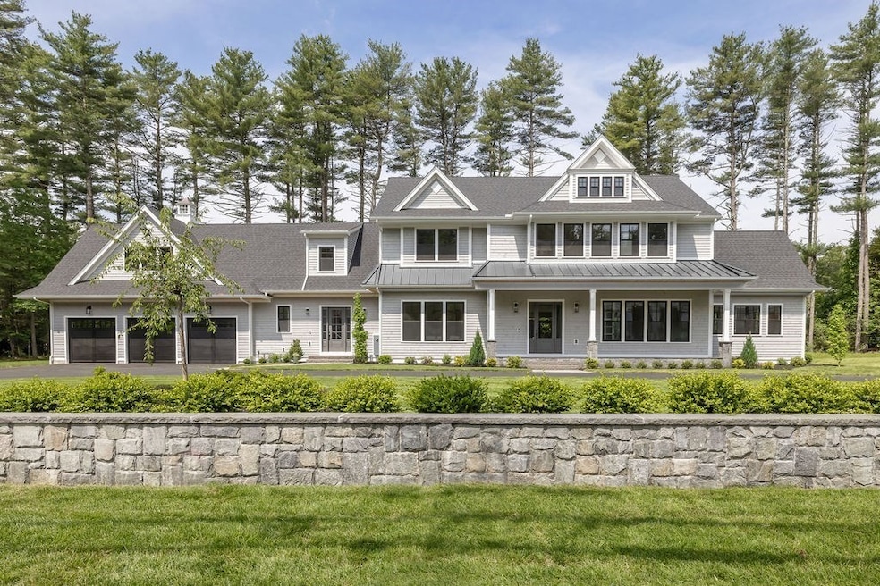
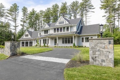
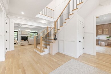


New construction luxury home by esteemed builder offers three levels of incredible living space. The main floor features an elegant foyer, formal dining room, office and open-concept family room with fireplace framed by French doors. Step out to spacious covered deck with a stone fireplace, patio, and yard. The chef’s kitchen has an expansive island, custom banquette, and two pantries. The paneled lounge includes a fireplace and wet bar. A first-floor ensuite, oversized mudroom with cabinetry, powder room, generous 3-bay garage offer unparalleled functionality. Ascend one of two stairways to find five additional ensuites including the luxurious primary with soaring ceilings, shiplap, floating shelves, balcony, fireplace, 5-piece bath, and closets. The finished lower level provides flexibility with a large rec room, media center, home gym and potential for sauna or wine cellar. A peaceful, private and level one acre property on a cul-de-sac, minutes to Wellesley and Needham centers.
| Date | Type | Sale Price | Title Company |
|---|---|---|---|
| Quit Claim Deed | $5,350,000 | -- | |
| Quit Claim Deed | $5,350,000 | -- | |
| Quit Claim Deed | $1,500,000 | None Available | |
| Quit Claim Deed | $1,500,000 | None Available | |
| Deed | -- | -- | |
| Deed | -- | -- | |
| Deed | -- | -- | |
| Deed | $800,000 | -- | |
| Deed | $800,000 | -- | |
| Deed | $459,000 | -- | |
| Deed | $459,000 | -- |
| Date | Status | Loan Amount | Loan Type |
|---|---|---|---|
| Previous Owner | $3,300,400 | Purchase Money Mortgage | |
| Previous Owner | $550,000 | Purchase Money Mortgage | |
| Previous Owner | $264,000 | Purchase Money Mortgage |
| Date | Event | Price | List to Sale | Price per Sq Ft |
|---|---|---|---|---|
| 07/15/2025 07/15/25 | Sold | $5,350,000 | -2.7% | $591 / Sq Ft |
| 06/09/2025 06/09/25 | Pending | -- | -- | -- |
| 06/02/2025 06/02/25 | For Sale | $5,499,000 | -- | $608 / Sq Ft |
| Year | Tax Paid | Tax Assessment Tax Assessment Total Assessment is a certain percentage of the fair market value that is determined by local assessors to be the total taxable value of land and additions on the property. | Land | Improvement |
|---|---|---|---|---|
| 2025 | $14,625 | $1,379,700 | $886,900 | $492,800 |
| 2024 | $15,109 | $1,206,800 | $712,200 | $494,600 |
| 2023 | $15,202 | $1,165,800 | $712,200 | $453,600 |
| 2022 | $13,054 | $976,400 | $539,700 | $436,700 |
| 2021 | $12,722 | $976,400 | $539,700 | $436,700 |
| 2020 | $12,173 | $974,600 | $539,700 | $434,900 |
| 2019 | $11,970 | $966,100 | $539,700 | $426,400 |
| 2018 | $11,477 | $966,100 | $539,700 | $426,400 |
| 2017 | $10,876 | $914,700 | $539,700 | $375,000 |
| 2016 | $10,603 | $918,800 | $539,700 | $379,100 |
| 2015 | $10,373 | $918,800 | $539,700 | $379,100 |
| 2014 | $10,552 | $906,500 | $539,700 | $366,800 |
Seller's Agent in 2025
Robert Ticktin
Hawthorn Properties
(617) 840-3463
45 in this area
75 Total Sales
Seller Co-Listing Agent in 2025
Dana Warren
Hawthorn Properties
(617) 794-5303
20 in this area
35 Total Sales
Buyer's Agent in 2025
Beyond Boston Properties Group
Compass
(781) 296-0966
20 in this area
183 Total Sales
Source: MLS Property Information Network (MLS PIN)
MLS Number: 73383612
APN: NEED-000305-000018
Disclaimer: Certain information contained herein is derived from information provided by parties other than Homes.com. All information provided is deemed reliable, but is not guaranteed to be accurate and should be independently verified.
![]() The property listing data and information, or the Images, set forth herein were provided to MLS Property Information Network, Inc. from third party sources, including sellers, lessors and public records, and were compiled by MLS Property Information Network, Inc. The property listing data and information, and the Images, are for the personal, non-commercial use of consumers having a good faith interest in purchasing or leasing listed properties of the type displayed to them and may not be used for any purpose other than to identify prospective properties which such consumers may have a good faith interest in purchasing or leasing. MLS Property Information Network, Inc. and its subscribers disclaim any and all representations and warranties as to the accuracy of the property listing data and information, or as to the accuracy of any of the Images, set forth herein.
The property listing data and information, or the Images, set forth herein were provided to MLS Property Information Network, Inc. from third party sources, including sellers, lessors and public records, and were compiled by MLS Property Information Network, Inc. The property listing data and information, and the Images, are for the personal, non-commercial use of consumers having a good faith interest in purchasing or leasing listed properties of the type displayed to them and may not be used for any purpose other than to identify prospective properties which such consumers may have a good faith interest in purchasing or leasing. MLS Property Information Network, Inc. and its subscribers disclaim any and all representations and warranties as to the accuracy of the property listing data and information, or as to the accuracy of any of the Images, set forth herein.
Ask me questions while you tour the home.