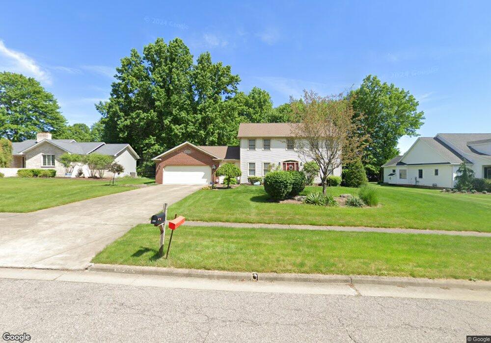
430 Janet Dr Canfield, OH 44406
Estimated Value: $456,140 - $476,000
4
Beds
3
Baths
2,556
Sq Ft
$183/Sq Ft
Est. Value
About This Home
This home is located at 430 Janet Dr, Canfield, OH 44406 and is currently estimated at $467,785, approximately $183 per square foot. 430 Janet Dr is a home located in Mahoning County with nearby schools including Canfield Village Middle School, Canfield High School, and St Charles Elementary School.
Ownership History
Date
Name
Owned For
Owner Type
Purchase Details
Closed on
Jun 9, 2003
Sold by
Solomon Scott E
Bought by
Solomon Marla A
Current Estimated Value
Purchase Details
Closed on
Jul 11, 1994
Sold by
Kale Richard W
Bought by
Solomon Scott E and Solomon Marla A
Home Financials for this Owner
Home Financials are based on the most recent Mortgage that was taken out on this home.
Original Mortgage
$152,100
Interest Rate
8.61%
Mortgage Type
New Conventional
Purchase Details
Closed on
Aug 24, 1990
Bought by
Kale Richard and Kale Joanne
Create a Home Valuation Report for This Property
The Home Valuation Report is an in-depth analysis detailing your home's value as well as a comparison with similar homes in the area
Home Values in the Area
Average Home Value in this Area
Purchase History
| Date | Buyer | Sale Price | Title Company |
|---|---|---|---|
| Solomon Marla A | -- | -- | |
| Solomon Scott E | $211,000 | -- | |
| Kale Richard | $181,500 | -- |
Source: Public Records
Mortgage History
| Date | Status | Borrower | Loan Amount |
|---|---|---|---|
| Closed | Solomon Scott E | $152,100 |
Source: Public Records
Tax History Compared to Growth
Tax History
| Year | Tax Paid | Tax Assessment Tax Assessment Total Assessment is a certain percentage of the fair market value that is determined by local assessors to be the total taxable value of land and additions on the property. | Land | Improvement |
|---|---|---|---|---|
| 2024 | $5,193 | $119,510 | $16,830 | $102,680 |
| 2023 | $5,112 | $119,510 | $16,830 | $102,680 |
| 2022 | $4,777 | $88,800 | $16,830 | $71,970 |
| 2021 | $4,637 | $88,800 | $16,830 | $71,970 |
| 2020 | $4,911 | $88,800 | $16,830 | $71,970 |
| 2019 | $4,419 | $77,230 | $14,640 | $62,590 |
| 2018 | $4,961 | $77,230 | $14,640 | $62,590 |
| 2017 | $4,685 | $77,230 | $14,640 | $62,590 |
| 2016 | $4,113 | $74,180 | $14,640 | $59,540 |
| 2015 | $4,022 | $74,180 | $14,640 | $59,540 |
| 2014 | $4,038 | $74,180 | $14,640 | $59,540 |
| 2013 | $3,892 | $74,180 | $14,640 | $59,540 |
Source: Public Records
Map
Nearby Homes
- 419 Carriage Hill Dr
- 473 Carriage Hill Dr
- 6859 Fairground Blvd
- 459 Holly St
- 125 Callahan Rd
- 6020 Century Blvd
- 227 Cross St
- 100 Talsman Dr
- 78 Neff Dr
- 120 Talsman Dr Unit 4
- 58 Skyline Dr
- 38 Skyline Dr
- 301 Hilltop Blvd
- 321 Hilltop Blvd
- 5025 Macy Ln
- 201 Talsman Dr Unit 1
- 7348 S Raccoon Rd
- 5034 Macy Ln
- 211 Talsman Dr Unit 1
- 6850 Abbey Rd N