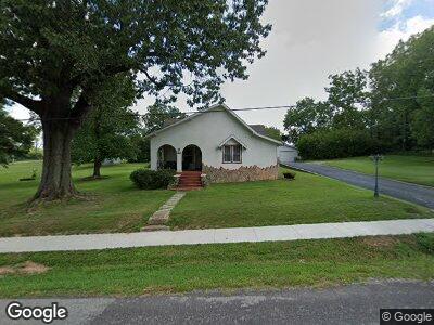
430 S Eagle St Norwood, MO 65717
Estimated Value: $89,098 - $208,000
2
Beds
--
Bath
1,330
Sq Ft
$102/Sq Ft
Est. Value
About This Home
This home is located at 430 S Eagle St, Norwood, MO 65717 and is currently estimated at $136,025, approximately $102 per square foot. 430 S Eagle St is a home with nearby schools including Norwood Elementary School, Norwood High School, and Southern Missouri Heritage Academy.
Create a Home Valuation Report for This Property
The Home Valuation Report is an in-depth analysis detailing your home's value as well as a comparison with similar homes in the area
Home Values in the Area
Average Home Value in this Area
Tax History Compared to Growth
Tax History
| Year | Tax Paid | Tax Assessment Tax Assessment Total Assessment is a certain percentage of the fair market value that is determined by local assessors to be the total taxable value of land and additions on the property. | Land | Improvement |
|---|---|---|---|---|
| 2024 | $5 | $9,230 | $0 | $0 |
| 2023 | $460 | $9,230 | $0 | $0 |
| 2022 | $424 | $8,310 | $0 | $0 |
| 2021 | $402 | $8,310 | $0 | $0 |
| 2020 | $421 | $8,170 | $0 | $0 |
| 2019 | $419 | $8,170 | $0 | $0 |
| 2018 | $428 | $8,410 | $0 | $0 |
| 2017 | $405 | $8,410 | $0 | $0 |
| 2016 | $396 | $8,410 | $0 | $0 |
| 2015 | -- | $8,060 | $0 | $0 |
| 2013 | -- | $8,060 | $0 | $0 |
Source: Public Records
Map
Nearby Homes
- 429 S Eagle Ave
- 629 S Eagle St
- 000 State Highway C
- 591 Hwy C
- 000 Taylor St
- 100 Jones Dr
- 1590 Fisk Rd
- TBD E Hwy
- 7197 Whetstone Rd
- 000 Cottengim Rd Unit 2
- 7210 Newkirk Rd
- 000 State Highway K Unit Lot B
- 000 State Highway K Unit Lot A
- 000 State Highway K
- 7528 Newkirk Rd
- 2799 Sparks Rd
- 1178 Hart Rd
- 7828 Newkirk Rd
- 000 Mcintosh Rd
- 24816 Co Unit 117
